
Welland in Niagara Region, Ontario — Central Canada (North America)
Battle of Cook's Mills - Oct. 19th 1814

Photographed by Kevin Westell, July 21, 2025
1. Battle of Cook's Mills - Oct. 19th 1814 - Marker

The Battle of Cook's Mills
On September 27, 1814, U.S. Major-General George Izard's First Division arrived on the Niagara Frontier from Sackets Harbor. On October 18, after becoming frustrated at finding British Lieutenant Major-General Gordon Drummond's army strongly entrenched behind their defences at Chippewa, he dispatched Brigadier-General Daniel Bissell's brigade from their Black Creek encampment to Cook's Mills. About 900 strong, this force was comprised of four infantry regiments; the 5th, 14th, 15th and 16th, supported by a company of the 4th Rifles, and a squadron of light dragoons. His mission was to reconnoitre the British right flank and to seize or destroy provisions thought to be stored there.
On October 19, Lieutenant-Colonel Christopher Myers, commanding a British force of about 750 men composed of the Glengarry Light Infantry Fencibles, the 82nd Regiment, the 100th Regiment, and supported by flank companies of the 104th Regiment, a rocket detachment and a Royal Artillery cannon, approached Cook's Mills. His instructions were to determine the purpose and direction of the invading force.
The battle began when advanced troops engaged in a bitter hand-to-hand fight in a wooded ravine leading into Lyon's Creek east of the present day cairn. The American defenders were at first forced back but with reinforcements, were able to push the British back out of the ravine. The U.S. troops, not venturing beyond the edge of the woods, opened a heavy musket fire from a distance while the British responded with their rockets and cannon. Bissell's men then attempted to out-flank Myers, convincing him to break contact and withdraw back to Chippewa.
Rather than pursue, the Americans continued to occupy Cook's Mills, buried the dead and destroyed a quantity of grain found at the mill. Leaving Cook's Mills on October 20, 1814, they fell back to Frenchman's Creek, having fought the last battle between regular forces in Canada.
On November 5, 1814, Fort Erie was destroyed and the last American troops evacuated Canada, which ended the gruelling 1814 Niagara campaign. On December 24,1814, the War of 1812 ended with the signing of the Treaty of Ghent ensuring the USA would never again have designs on Canada. In 2014, the United States and Canada celebrate two centuries of peace.
1. About 8 a.m., in a wooded ravine running into Lyon's Creek, the Glengarry Light Infantry engaged the Americans in battle. Their commander, Colonel Battersby, divided his troops into two parties. The first advanced toward the enemy at the head of the ravine; the second flanked them on the right, forcing the American troops back.
2. The light troops of the U.S. 5th Infantry and the 4th Rifles sustained the attack while reinforcements were hurried over a temporary bridge crossing the creek. As the American line gained strength, Captain Leonard's company of the 104th New Brunswick Regiment were sent to assist the Glengarries.
3. Supported by about four hundred fresh troops including U.S. Major Bernard's 14th Regiment, the British retreated a short distance out of the ravine. They formed behind a rail fence and were the light companies of the 82nd Regiment reinforced them.
4. Bernard's U.S. troops attempted to charge and capture the British cannon, but were stopped by a timely rocket volley. Then began a heavy musket fire from their position at the edge of the woods fronting the ravine, about 500 yards from the British line.
5. The remainder of U.S. Colonel Pinckney's 5th Infantry Regiment was ordered to skirt the woods north of the field and strike the British right flank. This move was noticed by Colonel Myers who ordered a tactical retreat about 10 a.m.
La Bataille de Cook's Mills
Le 27 septembre 1814, le Major-général américain George Izard de la première division arrive à la frontière du Niagara de sa base de Sackets Harbor. Le 18 octobre, après avoir été frustré de trouver l'armée du Lieutenant-major-général britannique Gordon Drummond, fortement retranchée derrière leurs fortifications à Chippewa, il a envoyé la brigade dirigée par le brigadier Daniel Bissell du camp de Black Creek à Cook's Mills. Forte d'environ 900 hommes, cette force avait 4 régiments d'infanterie : le 5e, le 14e, le 15e et le 16e. Ces régiments était soutenu par les fusiliers et un escadron de dragons légers. Sa mission a été de reconnaître le flanc droit britannique et de s'emparer ou de détruire les provisions censées avoir été entreposées. Le 19 octobre, le Lieutenant-colonel Christopher Myers, commandant une force britannique de quelque 750 hommes composé du Glengarry Light Infantry Fencibles; des régiments 82e et 100e, appuyée par des compagnies de flanc du 104e régiment, inclus un détachement de roquettes et un canon d'Artillerie Royale s'est approché de Cook's Mills. Ses instructions étaient de déterminer le but et la direction de la force d'invasion.
La bataille a commencé quand les troupes avancées se sont engagées dans un combat acharné au corps à corps dans un ravin boisé menant au ruisseau de Lyon à l'est du cairn actuel. Les défenseurs américains ont d'abord été repoussés mais avec des renforts, ont pu repousser les Britanniques hors du ravin. Les troupes américaines, ne s'aventurant pas au-delà de la lisière des bois ont ouvert le feu de mousquet à distance tandis que les Britanniques répondaient avec leurs roquettes et leurs canons. Les hommes de Bissell ont ensuite tenté de contourner Myers, le convainquant de rompre le contact et de se retirer à Chippewa. Plutôt que de poursuivre, les Américains continuent d'occuper Cook's Mills, enterrant les morts et détruisant une quantité de céréales trouvée au moulin. Les Américains quittent Le Cook's Mills le 20 octobre 1814 et se replient sur Frenchman's Creek après avoir livré la dernière bataille entre forces régulières au Canada.
Le 5 novembre 1814, le fort Érié est détruit et les dernières troupes américaines se retire du Canada, ce qui a mis fin à l'épuisante campagne du Niagara. C'est au 24 décembre 1814, que la guerre de 1812 a pris fin avec la signature du traité de Gand, assurant que les États-Unis n'envisageraient plus jamais de desseins sur le Canada. En 2014, les États-Unis et le Canada célèbrent deux siècles de paix.
1. Vers 8h00, dans un ravin boisé qui se jette dans Lyon's Creek, le Glengarry Light Infantry s'engage dans une bataille avec les Américains. Leur commandant, le Colonel Battersby, divise ses troupes en deux parties. Le premier s'avança vers l'ennemi vers la tête du ravin; le second les flanque à droite, forçant les troupes américaines à reculer.
2. Les troupes légères américaines du 5e regiment d'infanterie et les fusiliers du 4e ont soutenu l'attaque tandis que des renforts étaient précipités sur un pont temporaire traversant le ruisseau. Alors que la ligne américaine gagnait en force, la compagnie du capitaine Leonard du 104e régiment d'infanterie Nouveau-Brunswick fut envoyée pour aider les Glengarries.
3. Soutenus par environ 400 troupes fraîches, y inclus le 14e régiment du Major Américain Bernard, les Britanniques se retirèrent d'une courte distance du ravin. Ils se sont formes derrière une clôture de rail et one été renforces par les compagnies légères du 82e regiment.
4. Les troupes américaines de Bernard ont tenté de charger et de capturer le canon britannique, mais ont été arrêtées par une volée de roquettes opportun. Commence alors un feu nourri de mousquet à partir de leur position à la lisière des bois face au ravin, à environ 500 mètres de la ligne britannique.
5. Le reste du 5e régiment d'infanterie américain du colonel Pinckney reçut l'ordre de contourner les bois au nord du terrain et de frapper le flanc droit britannique. Ce mouvement a été remarqué par le colonel Myers qui a ordonné une retraite tactique autour de 10h00.
Topics.
this page online
Location. 42° 59.617′ N, 79° 11.111′ W. Marker is in Welland, Ontario, in Niagara Region. It is at the intersection of Lyons Creek Road and Doan's Ridge Road, on the right when traveling east on Lyons Creek Road. Touch for map. Marker is at or near this postal address: 682 Lyons Creek Road, Welland ON L3B 5N4, Canada. Touch for directions.

Regionally, this marker is on Ontario’s Golden Horseshoe and in Niagara Canada. It is also in Central Canada. Globally, it is in North America, the Western Hemisphere, the Western World, and the Anglosphere. Historically, it finds itself in what was once a British colony, the Viceroyalty of New France, the Haudenosaunee (Iroquois) Confederacy, and Rupert’s Land.
Other nearby markers. At least 8 other markers are within 5 kilometers of this marker, measured as the crow flies: Battle of Cook's Mills - Niagara Campaign 1814 (here, next to this marker); 50 Visages Militaires [50 faces of War - French marker] (a few

Photographed by Kevin Westell, July 21, 2025
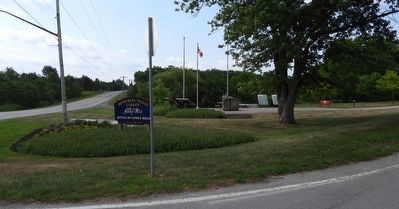
2. Battle of Cook's Mills - Oct. 19th 1814 - Marker in context
Photo faces south-east from Lyon's Creek Rd. Doan's Ridge Rd runs away to the right. This marker is north (left) of the flag-poles.
Photographed by Kevin Westell, July 21, 2025
3. Battle of Cook's Mills - Oct. 19th 1814 - Marker in context
Photo faces south from Lyon's Creek Rd. Doan's Ridge Rd is on the left. Parking is out-of-frame right.
Credits. This page was last revised on July 30, 2025. It was originally submitted on July 24, 2025, by Kevin Westell of St. Catharines, Ontario. This page has been viewed 109 times since then and 19 times this year. Photos: 1, 2, 3. submitted on July 24, 2025, by Kevin Westell of St. Catharines, Ontario. • Andrew Ruppenstein was the editor who published this page.
