Welland in Niagara Region, Ontario — Central Canada (North America)
Economic Impact
Welland Feeder Canal
Photographed by Kevin Westell, July 21, 2025
1. Economic Impact - Marker
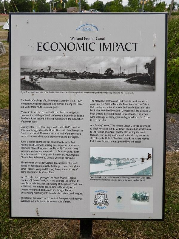
The Feeder Canal was officially opened November 14th, 1829. Immediately, engineers realized the potential of using the Feeder as a viable trade route to eastern ports.
Winter set in and the Feeder had to be closed to navigation. However, the building of boats and scows at Dunnville and along the Grand River became a thriving business with the expectation of summer trade.
On May 10th 1830 four barges loaded with 1600 barrels of flour were brought down the Grand River and taken through the Canal, at a price of 20 cents a barrel instead of the 80 cents a barrel it had cost when horse-drawn overland to Burlington.
Soon, a packet freight line was established between Port Robinson and Dunnville, making three trips a week under the command of Mr. Broadman. (see Figure 1) This was a very successful venture and was carried on for many years. Later, these boats carried picnic parties from the St. Paul Anglican Church, Port Robinson, to Christ's Church at Marshville.
The schooner Erie under Captain Bouquet from Cleveland bound for Youngstown was the first to pass down through the canal. Messrs.
this page online
In 1851, after the opening of the Second Canal. Thadius Hooker of Johnson Creek, N. Y. was awarded the contract to manufacture the brick for the building of the jail and courthouse at Welland. Mr. Hooker bought land in the vicinity of the present Hooker and Bald Streets and brought his hand brick-making machinery into Canada, via Lewiston, with wagons.
The Hooker bricks were noted for their fine quality and many of Welland's oldest business blocks were built of them.
The Morwood, Hobson and Hilder on the west side of the canal, and the Griffith Block, the Ross Store and the Orient Hall naming just a few, that were built on the east side. The brick kilns were fired by wood. Consequently the demand for brick created a splendid market for cordwood. The scows were kept busy for many years hauling wood from the Feeder to feed the kilns.
Abe Bradley's scow, "The Maggie Leason", carried cordwood to Black Rock and the "E. G. Lewis" was used on shorter runs to the Hooker Brick Yards and the ship fueling station at Welland. The fueling
Photographed by Kevin Westell, July 21, 2025
2. Economic Impact - Marker in context
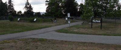
The photo faces east and south-east from Prince Charles Drive. The marker is one of the six around the marsh-pond within the feeder canal lock.
Erected by Welland Canal Recreational Canal Corporation.
Topics and series. This historical marker is listed in these topic lists: Industry & Commerce • Waterways & Vessels. In addition, it is included in the The Welland Canals series list. A significant historical year for this entry is 1829.
Location. 42° 58.442′ N, 79° 15.463′ W. Marker is in Welland, Ontario, in Niagara Region. It is at the intersection of Prince Charles Drive S and Ontario Road, on the right when traveling north on Prince Charles Drive S. The marker is one of six in a semi-circle around a small marsh-pond at the feeder canal lock, between two dog park fenced areas, 40 metres east of Prince Charles Drive and 40 metres east of Ontario Road. Touch for map. Marker is at or near this postal address: 383 Prince Charles Drive S, Welland ON L3B 5G4, Canada. Touch for directions.

Regionally, this marker is on Ontario’s Golden Horseshoe and in Niagara Canada. It is also in Central Canada. Globally, it is in North America, on the Great Lakes, in the Western Hemisphere, in the Western World, and in the Anglosphere. Historically, it finds itself in what was once a British colony, the Viceroyalty of New France, the Haudenosaunee (Iroquois) Confederacy, and Rupert’s Land.
Other nearby markers. At least 8 other markers are within walking distance of this marker: The Feeder Canal - Junction Lock - 1845 (here, next to this marker); The Decline (a few steps from this marker); The Origins (a few steps from this marker); Junction Village (a few steps from this marker); The Raceway (a few steps from this marker); The Eight Bridges (a few steps from this marker); Artist - Catharine Mills "Hockey" (approx. 0.9 kilometers away); Ukrainian Labour Temple 2005 (approx. one kilometer away). Touch for a list and map of all markers in Welland.
Credits. This page was last revised on July 25, 2025. It was originally submitted on July 23, 2025, by Kevin Westell of St. Catharines, Ontario. This page has been viewed 98 times since then and 18 times this year. Last updated on July 25, 2025, by Tim Boyd of Hamilton, Ontario. Photos: 1, 2. submitted on July 23, 2025, by Kevin Westell of St. Catharines, Ontario. • Devry Becker Jones was the editor who published this page.
