Catonsville in Baltimore County, Maryland — The American Northeast (Mid-Atlantic)
Paradise Train Station
Photographed by Pete Skillman, July 25, 2025
1. Paradise Train Station Marker
Inscription.
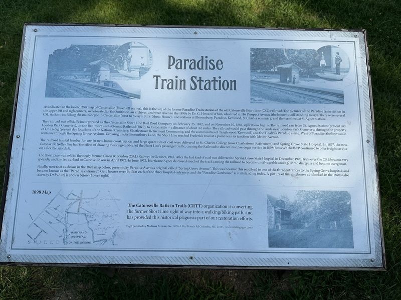
Paradise Train Station. . As indicated in the below 1898 map of Catonsville (lower left corner), this is the site of the former Paradise Train station of the old Catonsville Short Line (CSL) railroad. The pictures of the Paradise train station in the upper left and right corners, were located in the Smithsonian archives, and were taken in the 1890s by Dr. G. Howard White, who lived at 106 Prospect Avenae (the house is still standing today). There were several CSL stations including the main depot in Catonsville (next to today's Bill's Music House), and stations at Bloomsbury, Paradise, Kenwood, St Charles seminary, and the terminus at St Agnes station.
The railroad was officially incorporated as the Catonsville Short Line Rail Road Company on February 25, 1882, and on November 10, 1884, operations begin. The railroad ran from St. Agnes Station (present day Loudon Park Cemetery), on the Baltimore and Potomac Railroad (B&P), to Catonsville a distance of about 3.6 miles. The railroad would pass through the lands near Loudon Park Cemetery; through the property of Dr. Liebig (present day locations of the National Cemetery, Charlestown Retirement Community, and the communities of Tanglewood/Kenwood) and the Tinsley's Paradise estate. West of Paradise, the line would continue through the Spring Grove Asylum. Crossing under Bloomsbury Lane, the Short Line reached Frederick road at a point near its junction with Mellor Avenue.
The railroad hauled lumber for use in new home construction and large quantities of coal were delivered to St. Charles College (now Charlestown Retirement) and Spring Grove State Hospital. In 1897, the new Catonsville trolley line had the effect of drawing away a great deal of the Short Line's passenger traffic, causing the Railroad to discontinue passenger service in 1898, however the BBP continued to offer freight service on a flexible schedule.
The Short Line was sold to the newly formed Caton and Loudon (C&L) Railway in October, 1945. After the last load of coal was delivered to Spring Grove State Hospital in December 1970, trips over the C&L became very sporadic and the last carload to Catonsville was in April 1972. In June 1972. Hurricane Agnes destroyed much of the track causing the railroad to become unsalvageable and it fell into disrepair and became overgrown.
Finally, note that as shown in the 1898 map below, present day Paradise Ave was original called "Spring Grove Avenue". This was because this road lead to one of the three entrances to the Spring Grove hospital, and became known as the "Paradise entrance". Gate houses were built at each of the three hospital entrances and the "Paradise Gatehouse" is still standing today. A picture of this gatehouse as it looked in the 1890s (also taken by Dr White) is shown below (Lower right)
The Catonsville Rails to Trails (CRTT) organization is converting the former Short Line right of way into a walking/biking path, and has provided this historical plague as part of our restoration efforts.
(Captions):
1898 Map
(Sign provided by Madison Avenue, Inc., 9050-A Red Branch Rd Columbia, MD 21045, www.meetingsigns.com)
As indicated in the below 1898 map of Catonsville (lower left corner), this is the site of the former Paradise Train station of the old Catonsville Short Line (CSL) railroad. The pictures of the Paradise train station in the upper left and right corners, were located in the Smithsonian archives, and were taken in the 1890s by Dr. G. Howard White, who lived at 106 Prospect Avenae (the house is still standing today). There were several CSL stations including the main depot in Catonsville (next to today's Bill's Music House), and stations at Bloomsbury, Paradise, Kenwood, St Charles seminary, and the terminus at St Agnes station.
The railroad was officially incorporated as the Catonsville Short Line Rail Road Company on February 25, 1882, and on November 10, 1884, operations begin. The railroad ran from St. Agnes Station (present day Loudon Park Cemetery), on the Baltimore and Potomac Railroad (B&P), to Catonsville a distance of about 3.6 miles. The railroad would pass through the lands near Loudon Park Cemetery; through the property of Dr. Liebig (present day locations of the National Cemetery, Charlestown Retirement Community,
Click or scan to see this page online
and the communities of Tanglewood/Kenwood) and the Tinsley's Paradise estate. West of Paradise, the line would continue through the Spring Grove Asylum. Crossing under Bloomsbury Lane, the Short Line reached Frederick road at a point near its junction with Mellor Avenue.
The railroad hauled lumber for use in new home construction and large quantities of coal were delivered to St. Charles College (now Charlestown Retirement) and Spring Grove State Hospital. In 1897, the new Catonsville trolley line had the effect of drawing away a great deal of the Short Line's passenger traffic, causing the Railroad to discontinue passenger service in 1898, however the BBP continued to offer freight service on a flexible schedule.
The Short Line was sold to the newly formed Caton & Loudon (C&L) Railway in October, 1945. After the last load of coal was delivered to Spring Grove State Hospital in December 1970, trips over the C&L became very sporadic and the last carload to Catonsville was in April 1972. In June 1972. Hurricane Agnes destroyed much of the track causing the railroad to become unsalvageable and it fell into disrepair and became overgrown.
Finally,
Photographed by Pete Skillman, July 25, 2025
2. Paradise Train Station Marker - wide view
note that as shown in the 1898 map below, present day Paradise Ave was original called "Spring Grove Avenue". This was because this road lead to one of the three entrances to the Spring Grove hospital, and became known as the "Paradise entrance". Gate houses were built at each of the three hospital entrances and the "Paradise Gatehouse" is still standing today. A picture of this gatehouse as it looked in the 1890s (also taken by Dr White) is shown below (Lower right)
The Catonsville Rails to Trails (CRTT) organization is converting the former Short Line right of way into a walking/biking path, and has provided this historical plague as part of our restoration efforts.
(Captions):
1898 Map
(Sign provided by Madison Avenue, Inc., 9050-A Red Branch Rd Columbia, MD 21045, www.meetingsigns.com)
Location. 39° 16.259′ N, 76° 43.03′ W. Marker is in Catonsville, Maryland, in Baltimore County. It is on South Prospect Avenue, on the right when traveling south. Touch for map. Marker is at or near this postal address: 133 S Prospect Ave, Catonsville MD 21228, United States of America. Touch for directions.
Regionally, this marker is in Central Maryland. It is also in the American Mid-Atlantic, in the Chesapeake Bay Region, and on the Eastern Seaboard. Globally, it is in the North Atlantic Region, North America, the Western Hemisphere, the Western World, and the Anglosphere. Historically, it finds itself in what was once one of the original Thirteen Colonies and also the Antebellum South.
Also see . . . Catonsville Rails To Trails. Website of the organization that erected this marker. (Submitted on July 25, 2025, by Pete Skillman of Townsend, Delaware.)
Credits. This page was last revised on July 25, 2025. It was originally submitted on July 25, 2025, by Pete Skillman of Townsend, Delaware. This page has been viewed 250 times since then and 55 times this year. Photos:1, 2. submitted on July 25, 2025, by Pete Skillman of Townsend, Delaware.