Ducktown in Polk County, Tennessee — The American South (East South Central)
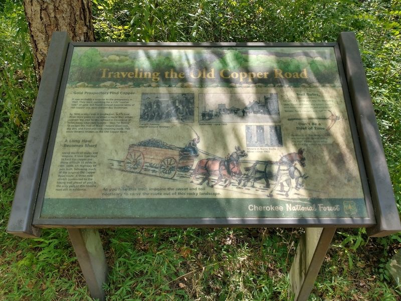
Traveling the Old Copper Road
Photographed by Tom Bosse, July 26, 2025
1. Traveling the Old Copper Road Marker
It was probably a surprise to the prospectors in 1843. They were searching for a rich "mother load" of gold, but found instead massive veins of rich copper ore, near present day Ducktown.
By 1850, a mine was in production, but it took three more years to construct a route that would connect the area to the railroad in Cleveland, 33 miles away. Cherokee Indians - here "in hiding" to escape the Trail of Tears - helped blast rock, dig dirt, and hand-pile rock retaining walls. This route became known as the Old Copper Road.
A Long Haul Becomes Short
Using teams of mules and wagons, it took two days to haul the copper ore those difficult 33 miles. In the 1930s, US Highway 64 was built, following much of the original Old Copper Road route. A three mile stretch (converted to the hiking trail ahead of you) is the only part of this historic road still in existence.
Trail Notes
Length: 2.4 miles one way (to the dam)
Uses: Open to hikers and bikers. Horses and motorized vehicles are prohibited.
Terrain: Fairly smooth and flat
Don't Be a Thief of Time
Remnants of the historic road
this page online
As you hike this trail, imagine the sweat and toil necessary to carve the route out of this rocky landscape.
[Caption]: Freight Haulers / Above Ground Workers
[Caption]: Ducktown - circa 1900
[Caption]: Miners in Burra Burra Mine - circa 1902
Erected by Cherokee National Forest.
Topics. This historical marker is listed in these topic lists: Industry & Commerce • Roads & Vehicles. A significant historical year for this entry is 1843.
Location. 35° 3.977′ N, 84° 27.689′ W. Marker is in Ducktown, Tennessee, in Polk County. It is on U.S. 64 west of State Road 68 when traveling west. Marker is located at the site of the Ocoee Whitewater Center which was burned in 2022. This is also a site of the 1996 Centennial Olympics. Touch for map. Marker is at or near this postal address: 4400 US-64, Turtletown TN 37391, United States of America. Touch for directions.

Regionally, this marker is in East Tennessee. It is also in the American South, specifically in the Upper South, in Appalachia, and specifically in Southern Appalachia. Globally,

Photographed by Tom Bosse, July 26, 2025
2. Traveling the Old Copper Road Marker
Other nearby markers. At least 8 other markers are within 5 miles of this marker, measured as the crow flies: The Old Copper Road (a few steps from this marker); Cherokee Heritage Trails (within shouting distance of this marker); The Heyday for Fire Towers (about 600 feet away, measured in a direct line); Tennessee Society DAR Memorial Forest (approx. 3.4 miles away); Ball Field (approx. 5.1 miles away); Clinic (approx. 5.1 miles away); Company Houses (approx. 5.1 miles away); Walkway Tunnel (approx. 5.1 miles away). Touch for a list and map of all markers in Ducktown.
Related markers. Click here for a list of markers that are related to this marker.
Also see . . . Ocoee Whitewater Center. (Submitted on July 27, 2025, by Tom Bosse of Jefferson City, Tennessee.)

Photographed by Tom Bosse, July 26, 2025
3. Traveling the Old Copper Road Marker

Photographed by Tom Bosse, July 26, 2025
4. Traveling the Old Copper Road Marker

Photographed by Tom Bosse, July 26, 2025
5. A Portion of the Old Copper Road
Credits. This page was last revised on July 31, 2025. It was originally submitted on July 27, 2025, by Tom Bosse of Jefferson City, Tennessee. This page has been viewed 113 times since then and 36 times this year. Photos: 1, 2, 3, 4, 5. submitted on July 27, 2025, by Tom Bosse of Jefferson City, Tennessee. • James Hulse was the editor who published this page.
