
Port Republic in Rockingham County, Virginia — The American South (Mid-Atlantic)
Shenandoah Valley Battlefields Historic District
Battle of Port Republic
| — | June 9, 1862 • Stonewall Jackson's Valley Campaign | — |
Photographed by Bradley Owen, July 21, 2025
1. Shenandoah Valley Battlefields Historic District Marker
Shenandoah At War
In 1996, Congress designated eight counties as the Shenandoah Valley Battlefields National Historic District, with a mission to preserve and interpret the region's Civil War battlefields and related historic sites. The effort is led by the Shenandoah Valley Battlefields Foundation. Port Republic is one of more than 20 battlefields that are part of the Foundation's work.
To learn more about the battle, the Valley's Civil War story, or to support our efforts, go to www.ShenandoahAtWar.org. To contact the Foundation, call 540-740-4545 or email [email protected].
Ashby's Resting Place and Stonewall's Escape
After famed Confederate cavalry leader Gen. Turner Ashby was killed in a skirmish outside of Harrisonburg on June 6, 1862, his body was brought here to the Frank Kemper House (today the Port Republic Museum) to be prepared for burial. Ashby's death contributed to Stonewall Jackson almost being captured near here two days later, on June 8, 1862, when the demoralized Confederate cavalry, bereft of their leader, allowed Union horsemen and artillery to dash into Port Republic without warning. Jackson
this page online
Visiting the Battlefield Today
Start your visit here at the Port Republic Museum and at the interpretive makers in town, then take Port Republic Road south to US 340, turn left, and drive 2.1 miles to the Coaling. The Cross Keys/Port Republic Battlefield Driving Tour (available at the front of the museum) lists those and other sites, as does the Shenandoah At War visitors guide.
For more on visiting Civil War sites throughout the area, visit or contact Harrisonburg Tourism and Visitor Services at the Hardesty-Higgins House Visitor Center in downtown Harrisonburg. (212 S Main St. Harrisonburg. 540-432-8935. www.VisitHarrisonburg VA.com. Open daily 9am-5pm.) The center also hosts the Civil War Orientation Center for the Harrisonburg-Rockingham Area.
"In every great battle of the war there was a hell spot. At Port Republic it was on the mountain side."
-

Photographed by Bradley Owen, July 21, 2025
2. Shenandoah Valley Battlefields Historic District Marker
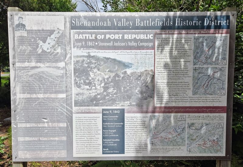
Battle of Port Republic
On June 8, 1862, Stonewall Jackson's Confederate troops had defeated the Federals at Cross Keys. The next day, Jackson turned towards the other Union force east of Port Republic. Moving his men proved more difficult than he had anticipated, and as the action began on the flat plain two miles beyond Port Republic, the Confederates were actually outnumbered. The compact Union line (commanded by Gen. Erastus Tyler) stretched from the river to "The Coaling," an open crest bristling with Union artillery that dominated the battlefield. The first Confederate assaults across the bottom-land were repulsed with heavy casualties.
Victory depended on who controlled "The Coaling." The initial Confederate assaults on the height were turned back, but eventually the crack Louisianan brigade of Gen. Richard Taylor swarmed over the Union guns, capturing the position in a vicious hand-to-hand fight. After failing to re-take "The Coaling" with their own determined counterattacks, the Union troops had to withdraw. Frémont's command soon reached the field, but was unable to reinforce Tyler because the Confederates had burned the North Bridge behind them. The Federals retreated north, bringing a close to Jackson's Valley Campaign.
June 9, 1862
Union Commander
Gen. Erastus Tyler
Confederate Commander
Gen. Stonewall Jackson
Forces Engaged
3,500 Union
6,000 Confederate
Estimated Casualties
1,002 Union
816 Confederate
Result:
Confederate Victory
"The shell from the battery on the coaling was ripping the ground open all around us... and I thought I was a goner."
- Corp. George M. Neese, Chew's (Virginia) Battery
Stonewall Jackson's Valley Campaign (March 23-June 9, 1862)
In the spring of 1862 during the Civil War, a Union army of 100,000 was approaching the Confederate capital of Richmond from the southeast. Another force of 30,000 men under Gen. Irvin McDowell was near Fredericksburg, ready to advance on Richmond from the north. By unleashing a vigorous offensive in the Shenandoah Valley, Confederate Gen. Thomas J. "Stonewall" Jackson sought to create a strategic diversion that would draw Federal troops away from the Confederate capital.
After an initial tactical setback at First Kernstown (March 23), Jackson moved south, eventually pausing at Conrad's Store (present-day Elkton). In early May, Jackson feinted east, then hurried west into the mountains to defeat Federal troops at McDowell (May 8). Returning to the main Valley, he united with Gen. Richard Ewell's force and marched north to defeat Federals at Front Royal (May 23) and First Winchester (May 25).
When Jackson continued north towards Harper's Ferry, two Union armies attempted to cut him off. Jackson eluded the trap and raced south, with the Federals pursuing him on both sides of Massanutten Mountain. Turning southeast at Harrisonburg, Jackson's army defeated the Federals at Cross Keys (June 8) and Port Republic (June 9). The Union forces then withdrew north, and Jackson, having accomplished his mission, moved east and joined Gen. Robert E. Lee in front of Richmond. Jackson's brilliant campaign not only tied up 60,000 Union troops, helping to save Richmond; it also infused new hope and enthusiasm for the Confederate cause.
(Caption):
Keith Rocco's painting pictures the struggle for the Coaling during the Battle of Port Republic (Courtesy Keith Rocco/Tradition Studios)
(Map Captions):
"They poured a volley into our ranks when we without delay returned the compliment... Here was the place to try mens [souls]"
- Union Sgt. John Hadley, 7th Indiana Infantry
"The 31st lay down in the ripening wheat and the sensation caused by the cutting of minie balls through the ripe grain was novel and not altogether pleasant."
- Lt. William R. Lyman, 31st Virginia Infantry
Erected 2010 by Shenandoah Valley Battlefields Foundation.
Topics. This historical marker is listed in this topic list: War, US Civil. A significant historical date for this entry is June 8, 1862.
Location. This marker has been replaced by another marker nearby. It was located near 38° 17.742′ N, 78° 48.649′ W. Marker was in Port Republic, Virginia, in Rockingham County. It was on Water Street just east of Port Republic Road (Virginia Route 253), on the left when traveling east. Marker is located in the parking lot on the east side of the Port Republic Museum. Touch for map. Marker was at or near this postal address: 8691 Water Street, Port Republic VA 24471, United States of America. Touch for directions.

Regionally, this marker was in Virginia’s Shenandoah Valley. It was also in the American South and specifically in the Upper South. Globally, it was in North America, the Western Hemisphere, the Western World, and the Anglosphere. Historically, it found itself in what was once the territory of the Mississippian Culture, one of the original Thirteen Colonies, one of the Confederate States of America, and the Antebellum South.
Other nearby markers. At least 8 other markers are within 2 miles of this location, measured as the crow flies: Port Republic Battlefield (here, next to this marker); a different marker also named The Frank Kemper House (here, next to this marker); The Point (about 400 feet away, measured in a direct line); North River Bridge (about 400 feet away); Palmer Lot at Middle Ford (approx. 0.2 miles away); a different marker also named Riverside Graveyard (approx. 0.3 miles away); a different marker also named Madison Hall (approx. half a mile away); Battle of Port Republic (approx. 1½ miles away). Touch for a list and map of all markers in Port Republic.
Other markers no longer nearby. The Frank Kemper House (was here, next to this marker but has been replaced with another marker now near it); a different marker also named North River Bridge (was about 500 feet away but has been replaced with another marker now near it); Riverside Graveyard (was approx. 0.3 miles away but has been replaced with another marker now near it); Port Republic Foundry (was approx. half a mile away but has been confirmed missing); Madison Hall (was approx. half a mile away but has been replaced with another marker now near it).
Related marker. Click here for another marker that is related to this marker. This marker has been replaced by another at this location.
Credits. This page was last revised on September 4, 2026. It was originally submitted on July 28, 2025, by Bradley Owen of Morgantown, West Virginia. This page has been viewed 201 times since then and 58 times this year. Photos: 1, 2. submitted on July 28, 2025, by Bradley Owen of Morgantown, West Virginia.
