Port Dalhousie in St. Catharines in Niagara Region, Ontario — Central Canada (North America)
The Harbour Lock of the First Welland Canal 1828-1847

Photographed by Kevin Westell, July 30, 2025
1. The Harbour Lock of the First Welland Canal 1828-1847 - Marker
In the early 1820s a group of Niagara-area businessmen promoted the idea of a canal to link Lake Ontario and Lake Erie. In 1824 the Welland Canal Company was incorporated to undertake the canal's construction. In 1825 plans for the canal route followed the natural channel of Twelve Mile Creek from St. Catharines to Lake Ontario, with a timber lock at the mouth of the creek to be the canal's northern entry, and the natural basin of the pond there the location for a harbour. The site chosen for the lock was a cut across the beach at the food of the western headland.
The harbour lock was designed as a guard lock between the lake and harbour, 32' wide and 130' long, with a lift of 5'. Clearing and excavation began in early 1826. Over 35,000
this page online
Protective piers extending into the lake to form the lock entrance were completed in 1828; a lighthouse was constructed at the piers by 1835.
The harbour was also completed in 1828, with a depth of 12' and covering 300 acres; it was created by constructing an embankment across the beach between the two headlands, together with excavation and dredging, raising the water level in the basin sufficiently deep for lake vessels.
The harbour lock (and the two locks south of it) had larger dimensions than the other first Welland canal locks, so that steamboats could travel inland from Lake Ontario to the village of St. Catharines.
For the labourers who built the lock and harbour, the work was difficult and dangerous. Described as "a motley assemblage of good and bad from almost
Photographed by Kevin Westell, July 30, 2025
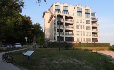
2. The Harbour Lock of the First Welland Canal 1828-1847 - Marker in context
Photo faces south-west. Lake Ontario is out-of-frame right.
The first vessel through the harbour lock was the schooner "Welland Canal," sailing from St. Catharines on May 10, 1828 with over 600 barrels of flour bound for Prescott for forwarding to Montreal. The schooner's passage through the lock was "greeted by a large concourse of spectators with long continued cheers...."
The first vessels to travel through the entire route of the Welland Canal began their passage at the harbour lock on November 27, 1829. Two schooners, the "Ann and Jane" of York, Upper Canada and the "R.H. Boughton" of Youngstown, New York, "decorated with flags and pendants" passed alongside the village "amid the spontaneous and hearty cheers" of onlookers.
Port Dalhousie grew and developed as the canal's northern terminus. An 1830 government report noted: "Already has the

Photographed by Kevin Westell, July 30, 2025
3. The Harbour Lock of the First Welland Canal 1828-1847 - Marker in context
Photo faces north-east. The marker is just left of the concrete walkway. The beach is 400 metres long. The Port Dalhousie piers extend out 600 metres into Lake Ontario. The oil products tanker is 4 kilometres away, in an anchorage near the current (4th) Welland canal.
In 1842 work began on a new canal of larger stone locks to replace the old timber locks, with Port Dalhousie remaining the canal's northern terminus. In 1848 a new and relocated Lock One and harbour were completed and brought into use. The old wooden lock that had been the making of Port Dalhousie was filled in and abandoned.
Erected by City of St. Catharines.
Topics and series. This historical marker is listed in these topic lists: Industry & Commerce • Waterways & Vessels. In addition, it is included in the Lighthouses, and the The Welland Canals series lists. A significant historical date for this entry is November 27, 1829.
Location. 43° 12.232′ N, 79° 16.039′ W. Marker is in St. Catharines, Ontario, in Niagara Region. It is in Port Dalhousie. It can be reached from the intersection of Lakeport Road and Hogan's Alley. The marker is at the west end of Port Dalhousie's public beach, adjacent to a concrete walkway - the Harbour Walkway Trail and also The Waterfront Trail. The marker is 100 metres east of the stairs that raise the walkway from the beach up to Dalhousie Avenue. Touch for map. Marker is at or near this postal address: 1 Lakeport Road, St Catharines ON L2N 5B3, Canada. Touch for directions.

Regionally, this marker is on the Golden Horseshoe and in Niagara Canada. It is also in Central Canada. Globally, it is in North America, on the Great Lakes, in the Western Hemisphere, in the Western World, and in the Anglosphere. Historically, it finds itself in what was once a British colony, the Viceroyalty of New France, the Haudenosaunee (Iroquois) Confederacy, and Rupert’s Land.
Other nearby markers. At least 8 other markers are within walking distance of this marker: Port Dalhousie Jail circa 1845 (about 150 meters away, measured in a direct line); Wellington House 1877 (about 180 meters away); John R Smith Butcher Shop 1875 (about 180 meters away); 12 Lock Street, Port Dalhousie (about 210 meters away); Sterling Bank of Canada 1907 (about 210 meters away); Port Dalhousie and the Niagara St. Catharines and Toronto Railway (NS&T) (about 210 meters away); Murphy & Scott Ship Chandler 1885 (about 210 meters away); Murphy's Ship Chandlery circa 1885 (about 210 meters away). Touch for a list and map of all markers in St. Catharines.
Credits. This page was last revised on August 13, 2025. It was originally submitted on July 30, 2025, by Kevin Westell of St. Catharines, Ontario. This page has been viewed 101 times since then and 27 times this year. Photos: 1, 2, 3. submitted on July 30, 2025, by Kevin Westell of St. Catharines, Ontario. • Andrew Ruppenstein was the editor who published this page.
