Near Santa Fe in Santa Fe County, New Mexico — The American Mountains (Southwest)
Hyde Memorial State Park
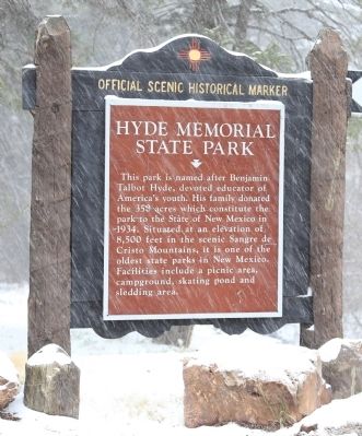
Photographed by J. J. Prats, April 27, 2014
1. Hyde Memorial State Park Marker
Erected by New Mexico Historic Preservation Division.
Topics. This historical marker is listed in this topic list: Environment. A significant historical year for this entry is 1934.
Location. 35° 43.824′ N, 105° 50.235′ W. Marker is near Santa Fe, New Mexico, in Santa Fe County. It is on Hyde Park Road (State Road 475 at milepost 15) east of Gonzales Road, on the right when traveling east. Touch for map. Marker is at or near this postal address: 740 Hyde Park Rd, Santa Fe NM 87501, United States of America. Touch for directions.

Regionally, this marker is in Northern New Mexico. It is also in the American Southwest, in the Mountain West, and on the Santa Fe Trail Corridor. Globally, it is in North America, the Rocky Mountains,
this page online
Other nearby markers. At least 8 other markers are within 6 miles of this marker, measured as the crow flies: Santa Fe Opera (approx. 5½ miles away); L. Bradford Prince (approx. 6 miles away); Welcome to Historic Fort Marcy (approx. 6 miles away); The Blockhouse Ruins (approx. 6 miles away); Witnessed from Fort Marcy Hill (approx. 6 miles away); First Army Fort in the Southwest (approx. 6 miles away); Invasion of Santa Fe (approx. 6 miles away); 1876 (approx. 6.1 miles away). Touch for a list and map of all markers in Santa Fe.
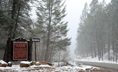
Photographed by J. J. Prats, April 27, 2014
2. Hyde Memorial State Park Marker
Credits. This page was last revised on August 12, 2025. It was originally submitted on April 27, 2014, by J. J. Prats of Powell, Ohio. This page has been viewed 1,285 times since then and 75 times this year. Last updated on July 30, 2025, by Bill Wingate of Albuquerque, New Mexico. Photos: 1, 2. submitted on April 27, 2014, by J. J. Prats of Powell, Ohio. • J. Makali Bruton was the editor who published this page.
Editor’s want-list for this marker. Photos of the park • Can you help?
