Hooker Ridge in Rains County, Texas — The American South (West South Central)
Hooker Cemetery
1851

Photographed by James Hulse, July 28, 2025
1. Hooker Cemetery Marker
Established in the Southwest corner of James Hooker's original land grant, Hooker Cemetery's first burial was Ann R. Hooker who died October 3, 1851. By the early 1900's the land was owned by Nathan Rabb, a son-in-law of James Hooker who deeded 8.4 acres to the cemetery. In 2003 Sherman Chapman and Rita Shepherd deeded an adjoining 2.5 acres for future expansion.
The name of the cemetery has always been Hooker Cemetery. Being located in the Hooker Ridge Community however, local people have referred to it as Hooker Ridge Cemetery. Early settlers brought slaves with them
this page online
Formed to provide ongoing care in the 1920's, the Hooker Cemetery Association was incorporated in 1974. The association has established burial fees and regulations, administers and maintains the cemetery, and meets annually to elect officers and transact business
Erected 2011 by Hooker Cemetery Association.
Topics. This historical marker is listed in this topic list: Cemeteries & Burial Sites. A significant historical date for this entry is October 3, 1851.
Location. 32° 55.076′ N, 95° 57.891′ W. Marker is in Hooker Ridge, Texas, in Rains County. It is at the intersection of Farm to Market Road 513 and County Road 1624, on the left when traveling north on Road 513. The marker is located at the front fence of the cemetery. Touch for map. Marker is at or near this postal address: 738 Farm To Market Rd 513, Lone Oak TX 75453, United States of America. Touch for directions.

Regionally, this marker is in the
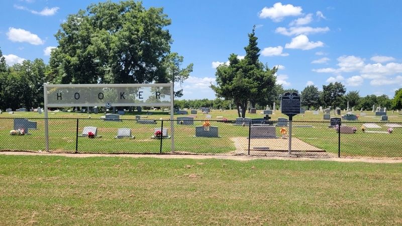
Photographed by James Hulse, July 28, 2025
2. Hooker Cemetery and Marker
Other nearby markers. At least 8 other markers are within 11 miles of this marker, measured as the crow flies: Texas Sharpshooter (about 300 feet away); Lake Tawakoni (approx. 2.7 miles away); Lone Oak Baptist Church (approx. 5½ miles away); Isaac Newton Gresham (approx. 5.6 miles away); Lone Oak Methodist Church (approx. 5.6 miles away); Caddo Indians in Hunt County (approx. 8.1 miles away); Camp Matthew F. Locke, C.S.A. (approx. 8.2 miles away); County Line School (approx. 11.1 miles away). Touch for a list and map of all markers in Hooker Ridge.
Another marker is no longer nearby. Judge James Hooker (was about 300 feet away, measured in a direct line but has been confirmed missing).

Photographed by James Hulse, July 28, 2025
3. The view of the Hooker Cemetery and Marker along the highway
Credits. This page was last revised on July 30, 2025. It was originally submitted on July 30, 2025, by James Hulse of Medina, Texas. This page has been viewed 160 times since then and 48 times this year. Photos: 1, 2, 3. submitted on July 30, 2025, by James Hulse of Medina, Texas.
