Central Oklahoma City in Oklahoma County, Oklahoma — The American South (West South Central)
Lake Overholser Dam

Photographed by Duane and Tracy Marsteller, June 21, 2025
1. Lake Overholser Dam Marker
Under the leadership of Mayor Edward Overholser in 1916, Oklahoma City citizens voted $1.5 million in bonds to construct the new water system. Plans drawn for a dam on the North Canadian River, about eight miles west of the city.
Construction began in 1917 on the hollow concrete Ambursen-type dam. At that time, concrete was expensive and labor was cheap. The project required a great deal of manual labor to form the dam and place concrete. Transporting materials was an amazing feat that was achieved with steam shovels, mules, a cable-crane system and a newly constructed railroad to the site. The dam was completed in 1938, at which time a commemorative inscription was dedicated to World War
this page online
A year later, Mayor Overholser resigned from office due to ill health. City commissioners named the reservoir and dam in his honor. Since 1918, Lake Overholser and Lake Overholser Dam have provided citizens with a dependable supply of water.
Overholer Dam was constructed to its present design in 1924, when the western earthen portion of the dam was beached during a flood. The spillway and main dam sections were modified in 1960. At 84 years of age in 2002, Overholser Dam underwent rehabilitation that replaced eroded concrete with spray-on gunite concrete. In 2004, a second project stabilized the dam's spillway by adding concrete to its original hollow structure.
The Overholser Dam was listed on the National Register of Historic Places on June 5, 2007.
Topics and series. This historical marker is listed in this topic list: Man-Made Features. In addition, it is included in the National Register of Historic Places (NRHP) series list. A significant historical year for this entry is 1918.
Location. 35° 29.165′ N, 97° 39.9′ W. Marker is in Oklahoma City, Oklahoma, in Oklahoma County.

Photographed by Duane and Tracy Marsteller, June 21, 2025
2. Lake Overholser Dam Marker

Regionally, this marker is in Central Oklahoma—Frontier Country. It is also in the American South, specifically on the prairies, and on the Southern Plains. Globally, it is in North America, the Western Hemisphere, the Western World, and the Anglosphere. Historically, it finds itself in what was once the territory of the Mississippian Culture and also the Louisiana Purchase.
Other nearby markers. At least 8 other markers are within 6 miles of this marker, measured as the crow flies: Council Grove (approx. 2.7 miles away); Yukon Czech Hall (approx. 4½ miles away); Yukon Facts (approx. 4.7 miles away); The Civilian Conservation Corps and Oklahoma City Will Rogers Park (approx. 4.8 miles away); Baum Building Cupola (approx. 5.4 miles away); Columns from Lee-Huckins Hotel (approx. 5.4 miles away); Charles Gasham Jones (approx. 5.4 miles
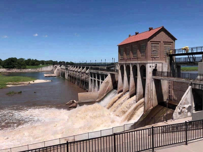
Photographed by Duane and Tracy Marsteller, June 21, 2025
3. Lake Overholser Dam
It is 1,650 feet long and 68 feet high (it was raised twice from its original 54-foot height). Behind it is Lake Overholser, which served as Oklahoma City's primary water source until 1947.
Another marker is no longer nearby. Ann's Chicken Fry House, Oklahoma City, Oklahoma (was approx. 4.4 miles away but has been permanently removed).
Also see . . . Lake Overholser Dam (PDF). National Register nomination for the dam, which was listed for its unique design as well as its impact on Oklahoma City's growth. (Prepared by Leslie Dixon, University of Central Oklahoma; via Oklahoma State Historic Preservation Office) (Submitted on July 31, 2025, by Duane and Tracy Marsteller of Murfreesboro, Tennessee.)

Photographed by Duane and Tracy Marsteller, June 21, 2025
4. Original 1918 plaque
This weathered plaque is on the dam's intake tower.

Photographed by Duane and Tracy Marsteller, June 21, 2025
5. Lake Overholser Dam Centennial Plaque
A daylong celebration was held when the dam was dedicated on April 22, 1918. Capping the day's festivities: A wedding.
Credits. This page was last revised on July 31, 2025. It was originally submitted on July 30, 2025, by Duane and Tracy Marsteller of Murfreesboro, Tennessee. This page has been viewed 307 times since then and 139 times this year. Photos: 1, 2. submitted on July 30, 2025, by Duane and Tracy Marsteller of Murfreesboro, Tennessee. 3, 4, 5. submitted on July 31, 2025, by Duane and Tracy Marsteller of Murfreesboro, Tennessee.
