
Welland in Niagara Region, Ontario — Central Canada (North America)
Welland Canal History
Histoire du Canal Welland

Photographed by Kevin Westell, August 1, 2025
1. Welland Canal History - Marker

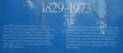
1829-1973
Until 1829, ships were barred from navigating between Lakes Erie and Ontario by the 100m drop of the Falls over the Niagara Escarpment. The opening of the Welland Canal in 1829 removed this barrier. Since then, canal facilities and routes have been progressively improved to accommodate larger ships, with four canals being built in 1829, 1851, 1881 and 1932.
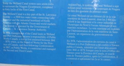
Today the Welland canal system uses seven locks to surmount the Niagara escarpment, compared to forty locks of the first canal.
The Welland canal is a key part of the St. Lawrence Seaway - a 3900 km water route connecting Lake Superior and the industrial heartland of North America with the Atlantic ocean and world markets. The Seaway is operated by the Government of Canada - St. Lawrence Seaway Authority.
In 1974, management of the Canal Lands in Welland and Port Dalhousie became a responsibility of Public Works Canada, a role it first assumed between 1841 - 1879, when, as the Board of Works for the Province of Canada, and then following Confederation in 1867, as Public Works, it constructed and managed the second and third canals.
Jusqu'en 1829, le dénivellement de 100 m des chutes Niagara empêchait les navires de passer du lac Erié au lac Ontario. L'ouverture du canal de Welland en 1829 a enlevé cet obstacle. Depuis lors, les aménagements et les routes du canal ont été améliorés graduellement pour accueillier de plus gros navires et quatre canaux ont été construits en 1829, 1851, 1881 et 1932.
Aujourd'hui, le système du canal Welland a sept écluses pour surmonter l'escarpement de Niagara au lieu des quarante du premier canal.
Le canal Welland est un élément clé de la voie maritime du Saint-Laurent, dont les 3 900 km relient le lac Supérieur et le coeur industriel de l'Amérique du
this page online
En 1974, l'administration des terrains du canal à Welland et à Port Dalhousie a été confiée à Travaux publics Canada, ministère qui l'avait déjà assurée entre 1841 et 1879, lorsque sous le nom d'Office des Travaux pour la Province du Canada, et sous le nom de Travaux publics, après la Confédération, il a construit et administré les 2e et 3e canaux.
Erected by Canada.
Topics and series. This historical marker is listed in this topic list: Waterways & Vessels. In addition, it is included in the The Welland Canals series list. A significant historical year for this entry is 1829.
Location. 42° 59.797′ N, 79° 14.77′ W. Marker is in Welland, Ontario, in Niagara Region. It is on Merritt Island, on the right when traveling west. The marker is one of a pair of markers, within a concrete circle in a park, 15 metres north-west of the parking lot at the dead end of Cross St. Touch for map. Marker is at or near this postal address: 6 Merritt Island,
Photographed by Kevin Westell, August 1, 2025
2. Welland Canal History - Marker in context
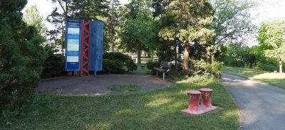
Photo faces south and south-west. The parking lot (left and out-of-frame left) is obscured by bushy trees. Welland's recreational canal is out-of-frame right.

Regionally, this marker is on Ontario’s Golden Horseshoe and in Niagara Canada. It is also in Central Canada. Globally, it is in North America, on the Great Lakes, in the Western Hemisphere, in the Western World, and in the Anglosphere. Historically, it finds itself in what was once a British colony, the Viceroyalty of New France, the Haudenosaunee (Iroquois) Confederacy, and Rupert’s Land.
Other nearby markers. At least 8 other markers are within walking distance of this marker: William Hamilton Merritt (here, next to this marker); Artist Sarah Beattie "Ship Saudades" (within shouting distance of this marker); Bridgetender's House c.1855 (approx. 0.4 kilometers away); 1855 The Bridgetender's House (approx. 0.4 kilometers away); Welland Canal Olympic Torch Relay / Relais de la flamme olympique de Welland (approx. 0.4 kilometers away); Gingerbread House c. 1890 (approx. 0.4 kilometers away); The Haun-Kenney House c. 1860 (approx. 0.4 kilometers away); Welland Canal Second Aqueduct (approx. 0.4 kilometers away). Touch for a list and map of all markers in Welland.
More about this marker.
Photographed by Kevin Westell, August 1, 2025
3. Marker text (top section)
Photographed by Kevin Westell, August 1, 2025
4. Marker text (bottom section)
Credits. This page was last revised on August 7, 2025. It was originally submitted on August 2, 2025, by Kevin Westell of St. Catharines, Ontario. This page has been viewed 86 times since then and 27 times this year. Photos: 1, 2, 3, 4. submitted on August 2, 2025, by Kevin Westell of St. Catharines, Ontario. • Andrew Ruppenstein was the editor who published this page.
