Near Mountainair in Socorro County, New Mexico — The American Mountains (Southwest)
Exploring Las Humanas
⎯⎯⎯
Explorando Las Humanas
Photographed by James Hulse, April 10, 2025
1. Exploring Las Humanas / Explorando Las Humanas Marker
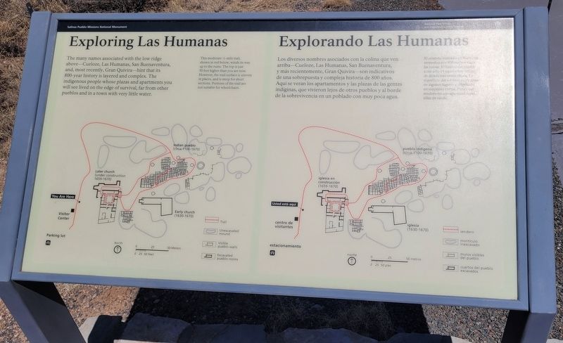
 The many names associated with the low ridge above - Cueloze, Las Humanas, San Buenaventura, and, most recently, Gran Quivira - hint that its 800 - year history is layered and complex. The indigenous people whose plazas and apartments you will see lived on the edge of survival, far from other pueblos and in a town with very little water.
This moderate ½-mile trail, shown in red below, winds its way up to the ruins. The top is just 50 feet higher than you are now. However, the trail surface is uneven in places, and is steep for short sections. Portions of the trail are not suitable for wheelchairs.
Map Details
(#1) Later church (under construction 1659-1670)
(#2) Indian pueblo (circa 1100-1670)
(#3) Early church (1630-1670)
Los diversos nombres asociados con la colina que ven arriba-Cueloze, Las Humanas, San Buenaventura, y más recientemente, Gran Quivira - son indicativos de una sobrepuesta y compleja historia de 800 años. Aqui se veran los apartamentos y las plazas de las gentes indíginas, que vivieron lejos de otros pueblos y al borde de la sobrevivencia en un poblado con muy poca agua.
El sendero indicado en línea roja serpentea por 800 metros hacia las ruinas. El final se encuentra a tan sólo 15 metros más arriba de donde está usted ahora. La superficie del sendero es irregular en algunos lugares y empinado en secciones cortas. Partes del sendero no son apropiados para sillas de rueda.
Detalles del mapa
(#1) iglesia en construcción (1659-1670)
(#2) pueblo indígena (circa 1100-1670)
(#3) iglesia (1630-1670)
Erected by Salinas
this page online
Topics. This historical marker is listed in these topic lists: Indigenous Peoples and Communities • Settlements & Settlers.
Location. 34° 15.588′ N, 106° 5.591′ W. Marker is near Mountainair, New Mexico, in Socorro County. It is on Wsmr S Rte 41 south of New Mexico Route 55. The marker is located on the grounds of the Salinas Pueblo Missions National Monument - Gran Quivíra Ruins. Touch for map. Marker is in this post office area: Mountainair NM 87036, United States of America. Touch for directions.

Regionally, this marker is in Southwest New Mexico and in the Rio Grande Valley. It is also in the American Southwest. Globally, it is in North America, the Western Hemisphere, the Western World, and the Anglosphere. Historically, it finds itself in what was once New Spain and also the Republic of Texas.
Other nearby markers. At least 8 other markers are within walking distance of this marker: One-seed juniper (within shouting distance of this marker); Soaptree yucca (within
Photographed by James Hulse, April 10, 2025
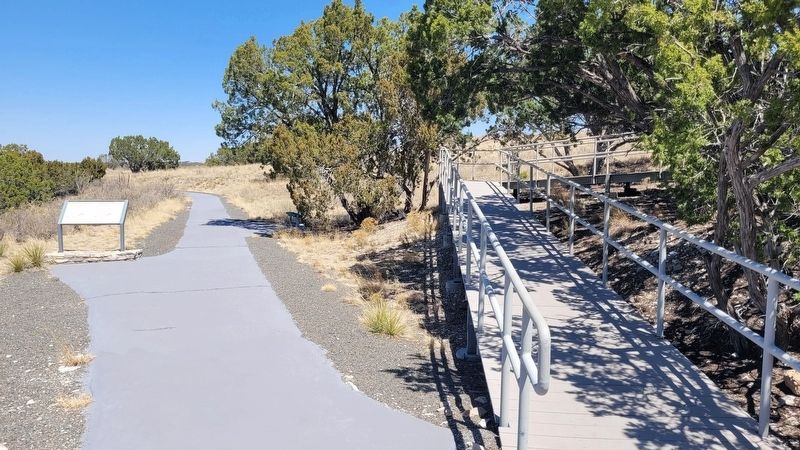
2. The view of the marker along the trail near the visitor’s center
Also see . . . Gran Quivira. National Park Service
The Gran Quivira unit of Salinas Pueblo Missions National Monument is the largest of the three units at 611 acres. Prior to Spanish contact, Gran Quivira was a vast city with multiple pueblos, and kivas. Mound 7, a 226 room structure from the Pueblo IV period (A.D.1275/1300-1600), is the largest and only fully excavated pueblo at the site. During the excavation, an older Circular Pueblo was discovered under Mound 7. First contact with the Spanish probably happened in 1583 with the arrival of Don Antonio de Espejo who mentions a settlement that sounds very similar to Gran Quivira. The Spanish returned in 1598 with the(Submitted on August 10, 2025, by James Hulse of Medina, Texas.)expedition of Don Juan de Oñate who was the first Spaniard to colonize what would become New Mexico. Oñate visited a pueblo he called Las Humanas which was the southernmost settlements. As part of the mission system, Las Humanas (Gran Quivira) was first placed under the Pecos Mission District. Later, with the arrival of Fray Alonso de Benavides in 1626, Gran Quivira was given more attention and later became a visita (a satellite mission without a resident Father) of Abó in 1629. That same year construction began on the first permanent mission at Gran Quivira. Under the supervision of Fray Francisco Letrado, rooms on the west end of Mound 7 (Letrado's Convento) were used by the Spanish for housing and probably an early chapel. Letrado was moved to the Zuni Pueblo in 1631 and Gran Quivira came under the control of Fray Francisco de Acevedo at the Abó Mission. Construction on Iglesia de San Isidro was completed in 1635. In 1659 Fray Diego de Santander was permanently assigned to Gran Quivira. Soon after, construction on a new larger church, San Buenaventura, began. By 1672 a combination of disease, drought, famine, and Apache raiding led to the abandonment of Gran Quivira.Photographed by James Hulse, April 10, 20253. The view of the visitor’s center
Credits. This page was last revised on August 10, 2025. It was originally submitted on August 10, 2025, by James Hulse of Medina, Texas. This page has been viewed 103 times since then and 32 times this year. Photos: 1, 2, 3. submitted on August 10, 2025, by James Hulse of Medina, Texas.
