Port Dalhousie in St. Catharines in Niagara Region, Ontario — Central Canada (North America)
History on the Former Mill and Carpentry Shop of the Port Dalhousie Gate Yard

Photographed by Kevin Westell, August 10, 2025
1. History on the Former Mill and Carpentry Shop of the Port Dalhousie Gate Yard - Marker
In 1927, a saw mill and carpentry shop existed on the property along with other buildings including lumber storage. Two years later in 1929, a two storey brick-clad, wood-frame building existed as a mill within the Government Gate Yard. The first floor was used as a mill and the second storey as a carpentry shop. Attached to the building was a two storey machine shop and a single storey boiler room.
On July 17, 1951, the Board of Works sold the land to the Trustees of the Royal Canadian Legion Branch #350. After the purchase of the property, the building was no longer used for mill operations. Interior renovations were made by the Legion to the building shortly after ownership.
The building was used for the Royal Canadian Legion Branch #350 until
this page online
Erected by City of St. Catharines.
Topics and series. This historical marker is listed in these topic lists: Fraternal or Sororal Organizations • Waterways & Vessels. In addition, it is included in the The Welland Canals series list. A significant historical year for this entry is 1844.
Location. 43° 12.074′ N, 79° 15.91′ W. Marker is in St. Catharines, Ontario, in Niagara Region. It is in Port Dalhousie. It can be reached from Lakeport Road, on the right when traveling north. The marker is affixed around the north side of the building at 57 Lakeport; but is affixed to an east-facing wall on a projecting section. Touch for map. Marker is at or near this postal address: 57 Lakeport Road, St Catharines ON L2N 4P6, Canada. Touch for directions.

Regionally, this marker is on the Golden Horseshoe and in Niagara Canada. It is also in Central Canada. Globally, it is in North America, on the Great Lakes, in the

Photographed by Kevin Westell, August 10, 2025
2. History on the Former Mill and Carpentry Shop of the Port Dalhousie Gate Yard - Marker in context
Photo faces west and north-west. The marker is on an east facing wall, near a bicycle rack.
Other nearby markers. At least 8 other markers are within walking distance of this marker: The Welland Canals Historical Fence (within shouting distance of this marker); Barnesdale Streetcar Stop 1908 (within shouting distance of this marker); The Pull (within shouting distance of this marker); Lock One of the Second Welland Canal (within shouting distance of this marker); Murphy's Ship Chandlery circa 1885 (about 120 meters away, measured in a direct line); Murphy & Scott Ship Chandler 1885 (about 120 meters away); First Women Rowers In The Royal Canadian Henley Regatta 1948 (about 120 meters away); The Muir Brother's Dry Docks (about 120 meters away). Touch for a list and map of all markers in St. Catharines.
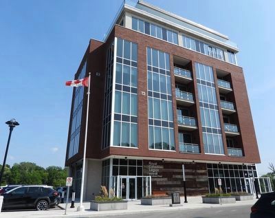
Photographed by Kevin Westell, August 10, 2025
3. History on the Former Mill and Carpentry Shop of the Port Dalhousie Gate Yard - Marker in context
Photo faces south-east from near Lakeport Rd. Where the north side has a projection bracketed by two concrete cylindrical supports, the bicycle rack and marker are concealed, past the second support.
Credits. This page was last revised on August 12, 2025. It was originally submitted on August 11, 2025, by Kevin Westell of St. Catharines, Ontario. This page has been viewed 92 times since then and 24 times this year. Photos: 1, 2, 3. submitted on August 11, 2025, by Kevin Westell of St. Catharines, Ontario. • Andrew Ruppenstein was the editor who published this page.
