Franklin Township near Antonis in Ross County, Ohio — The American Midwest (Great Lakes)
Scioto Trail
Photographed by Craig Doda, August 2, 2025
1. Scioto Trail Marker
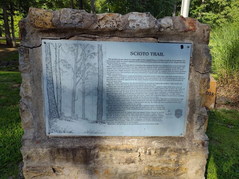
The woods you are about to enter reflects the natural history of Ohio as well as its grandeur. Yet its present state is a mere shadow of the primeval forest which was once part of the largest decidu- ous woodland on earth.
The assemblage of plants which comprises the present forests has changed and evolved through time. Approximately 12,000 years ago, glacial ice still lay in the northern reaches of the state. The climate was cooler and wetter and spruce forests thrived at the glacier's margins. As the ice withdrew and the climate warmed, these boreal forests were not able to compete with the faster growing hardwood trees. The northern species retreated to Canada with only isolated pockets remaining in damp cool gorges.
The climate continued a gradual warming trend until about 7,000 years ago when temperatures averaged several degrees warmer than present. The grasslands of the Great Plains spread eastward and patches of prairie appeared in the state. Islands of giant bur oak trees swam in thousands of acres of open land.
As the climate moderated, the deciduous forest encroached upon the prairies. Only small remnants
this page online
Those who saw the magnificient virgin forest reported that a squirrel could climb into a tree in Pennsylvania and travel all the way to Indiana without ever coming down to the ground. The boles of the ancient trees stood as sentinels across the forest floor darkened by a spreading canopy that blotted out the sun. So little grew in the understory the wary deer could spot a hunting Shawnee a good distance away. Broad streams provided for but a single silver streak of sky, yet they alone allowed a bit of sunshine to touch the rich earth. Giants not rivaled by today's record trees crowded every hillside and reached for the clouds on the flat western plains.
The early settlers regarded this forest as a somewhat dismal place. They were accustomed to and sought the bright sunny fields of their homelands and they needed fields for crops and logs for cabins. The trees, therefore, began to fall beneath the axe. By 1900, the once expansive forest was reduced to less woodland than we see today.
Areas such as this included in the park have regained mature forest status. The trees are
Photographed by Craig Doda, August 2, 2025
2. Scioto Trail Marker
If left to its own devices, mature does not always create a forest as an end product to years of succession. What plant species thrive, replace others, die out, or grow to maturity are determined by a number of factors. Climate, terrain and soil types all play a role in the development of a pattern which will eventually lead to a stable, little changing community, whether it be jee woodland, bog or prairie. Different conditions even lead to various forest types such as oak-hickory or beech-maple.
Remember the heritage of our woodlands as you follow these trails.
Topics. This historical marker is listed in these topic lists: Horticulture & Forestry • Parks & Recreational Areas • Settlements & Settlers. A significant historical year for this entry is 1900.
Location. 39° 13.803′ N, 82° 57.267′ W. Marker is near Antonis, Ohio, in Ross County. It is in Franklin Township. It is at the intersection of Lake Drive and Stoney Creek Road (Ohio Route 372), on the right when traveling east on Lake Drive. Touch for map. Marker is at or near this postal address: 274 Lake Dr, Chillicothe OH 45601, United States of America. Touch for directions.

Regionally, this marker is in the Scioto Valley and in Southern Ohio Hill Country. It is also in the American Midwest, in the Corn Belt, and in Northern Appalachia. Globally, it is in North America, the Western Hemisphere, the Western World, and the Anglosphere. Historically, it finds itself in what was once the Viceroyalty of New France, the Haudenosaunee (Iroquois) Confederacy, the territory of the Mississippian Culture, and the Northwest Territory.
Other nearby markers. At least 8 other markers are within 5 miles of this marker, measured as the crow flies: The Lending Tackle Box Tackle Box Program (a few steps from this marker); Historic Log Church Replica (within shouting distance of this marker); William Hewitt Monument (within shouting distance of this marker); Scioto Trail Fire Tower (approx. 1½ miles away); Ohio Forest Management Through the Years (approx. 1½ miles away); The American Chestnut (approx. 1½ miles away); Ross County Underground Railroad / The Underground Railroad (approx. 1.9 miles away); German Settlers & Trustees Memorial (approx. 4.9 miles away).
Credits. This page was last revised on August 28, 2025. It was originally submitted on August 13, 2025, by Craig Doda of Napoleon, Ohio. This page has been viewed 100 times since then and 32 times this year. Photos: 1, 2. submitted on August 13, 2025, by Craig Doda of Napoleon, Ohio. • Devry Becker Jones was the editor who published this page.
