Port Colborne in Niagara Region, Ontario — Central Canada (North America)
The Railway Era - The Coming of the Railways
Le Chemin De Fer Era - L'arrivèe des Chemins de Fer

Photographed by Kevin Westell, August 14, 2025
1. The Railway Era - The Coming of the Railways - Marker

The Railway Era - The Coming of the Railways
In 1854 the east-west Buffalo to Lake Huron Railway (later to become part of the Grand Trunk Railway) was opened through Port Colborne. Four years later in 1859 the north-south Welland Railway was completed along the canal route from Port Dalhousie to Port Colborne. The two sets of tracks crossed near this sign.
In 1880, a Union Station, which served both railways, was built here at the crossing point. It was replaced c. 1912 by a new and larger Union Station in the same location. When the canal was widened in the 1920's and East Street was removed, this second station was torn down and a replacement station, which still stands, was built across the canal.
In 1911, a locomotive mistakenly attempted to cross the old canal at a time when the railway swing bridge was open to allow a boat to pass through. The wreckage of the locomotive had to be removed from the bottom of the canal.
Le Chemin De Fer Era - L'arrivèe des Chemins de Fer
En 1854 le chemin de fer reliant l'est-ouest de Buffalo au Lac Huron (devenant plus tar d'une partre du chemin de fer Grand trunk) passait au travers de Port Colborne. Quatre ans plus tard, en 1859, le Chemin de fer nord-sud de Welland longeaint complètement la route du canal de Port Dalhousie à Port Colborne. Ces deux chemins de fer traversait tout près de cette enseigne.
En 1880, la gare qui portait le nom de "Union Station" déseravit les deux chemins de fer. Elle a été construit à leur point de recontre. En 1912, au même entroit ie en ont construit une plus grosse car elle ne suffisait plus. Lorsque le canal fût èlargie en 1920 et que la rue East à été déplacée, la "Union Station" cessa de fonctionner. Une autre fût construite directement au travers du canal et elle existe encore
this page online
En 1911, un train a accidentallement basculé dans le canal en traversant au même moment ou le chemin de fer silué sur le pont tournant était ouvert pour laisser passer un bateau. Les décombres du train on été difficilement retirés de la profondeur du canal.
Topics. This historical marker is listed in these topic lists: Railroads & Streetcars • Waterways & Vessels. A significant historical year for this entry is 1854.
Location. 42° 53.234′ N, 79° 14.865′ W. Marker is in Port Colborne, Ontario, in Niagara Region. It can be reached from Canal Bank Road, on the right when traveling east. Touch for map. Marker is at or near this postal address: 46 Canal Bank Road, Port Colborne ON L3K 1E3, Canada. Touch for directions.

Regionally, this marker is on the Golden Horseshoe and in Niagara Canada. It is also in Central Canada. Globally, it is in North America, on the Great Lakes, in the Western Hemisphere, in the Western World, and in the Anglosphere. Historically, it finds itself in what was once a British colony, the Viceroyalty of New France, the Haudenosaunee (Iroquois) Confederacy, and Rupert’s
Photographed by Kevin Westell, August 14, 2025
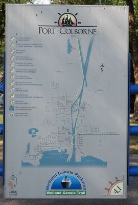
2. The Railway Era - The Coming of the Railways - reverse side of marker
This is a map of Port Colborne, showing the locations of this series of historical panels. Most still exist.
Other nearby markers. At least 8 other markers are within walking distance of this marker: The Welland Canal (about 180 meters away, measured in a direct line); Crossing The Canal / La Traversé Du Canal (about 240 meters away); Imperial Bank c.1911 (approx. 0.3 kilometers away); Imperial Bank of Canada Building (approx. 0.3 kilometers away); Port Colborne and the Niagara St. Catharines and Toronto Railway (NS&T) (approx. 0.3 kilometers away); Founding of Port Colborne (approx. 0.3 kilometers away); Earth Scraper Used On Construction of Welland Canal (approx. 0.3 kilometers away); Hand operated winch from 2nd Welland Canal Lock Gate (approx. 0.3 kilometers away). Touch for a list and map of all markers in Port Colborne.
Photographed by Kevin Westell, August 14, 2025
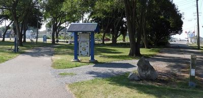
3. The Railway Era - The Coming of the Railways - Marker in context
Photo faces south and south east from near Canal Bank Road. The marker is left (in front of the bicycle) of the left-hand walking path (the path to the gazebo near Clarence St).
Credits. This page was last revised on August 16, 2025. It was originally submitted on August 15, 2025, by Kevin Westell of St. Catharines, Ontario. This page has been viewed 156 times since then and 9 times this year. Photos: 1, 2, 3. submitted on August 15, 2025, by Kevin Westell of St. Catharines, Ontario. • Andrew Ruppenstein was the editor who published this page.
