
Near Breckenridge in Summit County, Colorado — The American Mountains (Southwest)
Hoosier Pass

Photographed by Cosmos Mariner, July 26, 2025
1. Hoosier Pass Marker
The Utes
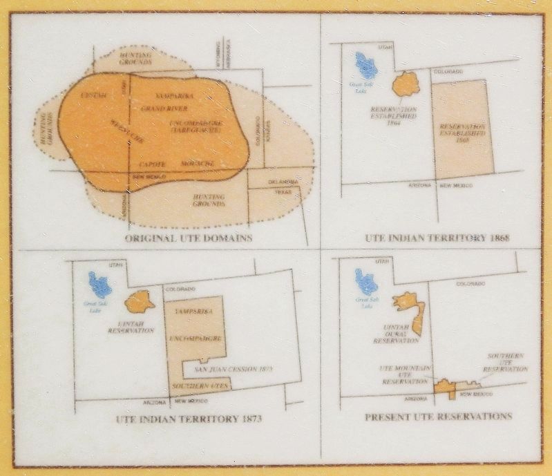
For many centuries, Hoosier Pass served as a link between two important Ute hunting grounds — South Park and Middle Park — the heart of the tribe's mountain domain. By the 1400s or 1500s these hunter-gatherers occupied territory from Utah's desert to the Front Range of present-day Colorado. Their mastery of the horse, introduced by Spaniards in the 1600s and their superior topographical knowledge made the Utes powerful warriors, and they routinely dispatched other tribes who challenged them for control of South Park. Although early non-Indian visitors generally went unchallenged, permanent settlers were not welcome. But in the late nineteenth century, the tide of pioneers finally forced the Utes out of their mountain strongholds. By the 1880s they had been confined to reservations in Colorado and Utah.
Immediately below us was a green valley, through which ran a stream; and a short distance opposite rose snowy mountains, whose summits were formed into peaks of naked rock.
—John C. Frémont, Hoosier Pass, June 23, 1844
John C. Frémont
Returning home from California on the second of his five western expeditions, John
this page online
[photo captions]
• Map drawn by Charles Preuss during Frémont’s 1842 exploration of the Rocky Mountains
• John and Jessie Frémont, late 1880s. John Frémont was a presidential candidate in 1856, served as General of the West during the Civil War, and, for a time, as governor of Arizona. During their later years, having lost their fortune, the Frémonts lived off the income from Jessie’s
Colorado Historical Society
2. Marker detail: Ute Indian Territories and Reservations
The Utes are a confederation of seven bands — Moache, Capote, Weeminuche, Tabeguache, Grand River, Yampa, and Uintah. Today, the Moache and Capote comprise the Southern Utes, the Weeminuche the Ute Mountain Utes, and the other four bands are considered the Northern Utes.
Erected 2002 by Colorado Historical Society, Colorado Department of Transportation, and Federal Highway Administration.
Topics and series. This historical marker is listed in these topic lists: Exploration • Indigenous Peoples and Communities • Settlements & Settlers. In addition, it is included in the History Colorado series list. A significant historical date for this entry is June 23, 1844.
Location. 39° 22.339′ N, 106° 3.403′ W. Marker is near Breckenridge, Colorado, in Summit County. It is on State Highway 9 0.3 miles south of County Road 670, on the left when traveling south. The marker is in a pull-out 1.3 miles north of the Hoosier Pass summit. Touch for map. Marker is in this post office area: Breckenridge CO 80424, United States of America. Touch for directions.

Regionally, this marker is in the Colorado High Rockies and on the Continental Divide. It is also in the American Mountain West. Globally, it is in North America, the Rocky Mountains, the Western Hemisphere, the Western World, and the Anglosphere.
Other nearby markers. At least 8 other markers are within 7 miles of this marker, measured as

Photographed by Cosmos Mariner, July 26, 2025
3. Hoosier Pass Marker
Looking east from the pull-out on Colorado Highway 9. This marker is the leftmost of two panels in this Colorado Historical Society interpretive kiosk.
Related markers. Click here for a list of markers that are related to this marker. Hoosier Pass
Also see . . .
1. Hoosier Pass, South of Breckenridge, Elevation 11,539’.
Excerpt: The first European explorers to document a crossing of the Continental Divide at today’s Hoosier Pass were the members of the Frémont Expedition in June 1844. Led by military leader and great “Pathfinder” John C. Frémont, the expedition crossed from the north (Breckenridge side) to the south following a buffalo trace, or worn migration path.(Submitted on August 18, 2025, by Cosmos Mariner of Cape Canaveral, Florida.)
2. John C. Frémont (Colorado Encyclopedia).
(by Stephen C. Schell) Excerpt: John Charles Frémont (1813–90) was an American explorer and cartographer for the US Topographical Engineers who crossed Colorado on various expeditions. Between 1842 and 1853, Frémont led five western expeditions with numerous objectives. He was also involved in the Mexican-American War (1846–48) in California, became one of California’s first senators, ran for president in 1856, served as commander of the army’s Department of the West during the Civil War, and became very wealthy through speculation in railroad development, only to lose his property and savings.(Submitted on August 18, 2025, by Cosmos Mariner of Cape Canaveral, Florida.)In Colorado, Frémont’s most prominent legacy remains his expeditions, which helped map the future Centennial State, informed the national discussion about railroads to the Pacific, and leant his name to such places as Fremont County and Fremont Street in Denver.
Credits. This page was last revised on August 18, 2026. It was originally submitted on August 18, 2025, by Cosmos Mariner of Cape Canaveral, Florida. This page has been viewed 96 times since then and 20 times this year. Photos: 1, 2, 3. submitted on August 18, 2025, by Cosmos Mariner of Cape Canaveral, Florida.
