Falls Church, Virginia — The American South (Mid-Atlantic)
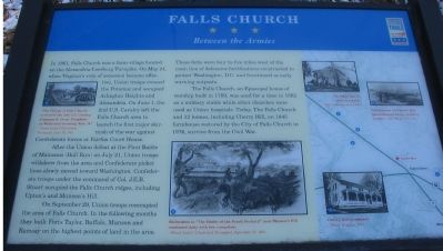
Falls Church
Between the Armies
After the Union defeat at the First Battle of Manassas (Bull Run) on June 21, Union troops withdrew from the area and Confederate picket lines slowly moved toward Washington. Confederate troops under the command of Col. J.E.B. Stuart occupied the Falls Church ridges, including Upton's and Munson's Hill.
On September 29, Union troops reoccupied the area of Falls Church. In the following months they built Forts Taylor, Buffalo, Munson and Ramsay on the highest points of land in the area. These forts were four to five miles west of the main line of defensive fortifications constructed to protect Washington, D.C. and functioned as early warning outposts.
The Falls Church, an Episcopal house of worship built in 1769, was used for a time in 1862 as a military stable while other churches were used as Union hospitals. Today, the Falls Church and 12 homes, including Cherry Hill, an 1845 farmhouse restored by the City of Falls Church in 1976, survive from the Civil War.
Erected by Civil War Trails.
Topics and series. This historical marker is listed in this topic list: War, US Civil. In addition, it is included in the Virginia Civil War Trails series list. A significant historical month for this entry is May 1910.
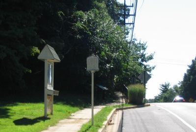
Location. 38° 52.522′ N, 77° 9.477′ W. Marker is in Falls Church, Virginia. Marker is on North Roosevelt Street, on the right when traveling east. Located at a pull off just short of the entrance to Oakwood Cemetery. Touch for map. Marker is in this post office area: Falls Church VA 22046, United States of America. Touch for directions.
Other nearby markers. At least 8 other markers are within walking distance of this marker. Taylor’s Tavern (here, next to this marker); a different marker also named Taylor’s Tavern (within shouting distance of this marker); Fairfax Chapel (about 300 feet away, measured in a direct line); Tallwood (approx. 0.2 miles away); Vietnamese Immigrants in Northern Virginia (approx. 0.3 miles away); Dulin Methodist Church (approx. 0.3 miles away); Fort Buffalo (approx. 0.4 miles away); Wren’s Tavern (approx. half a mile away). Touch for a list and map of all markers in Falls Church.
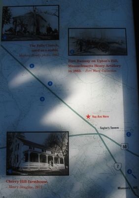
More about this marker. A map on the right side has letters correlated to pictures on the marker:
(A)-Upper right side - a drawing showing "The Village of Falls Church - arrival
of the 2nd U.S. Cavalry, Company B, Lieut. Tompkins, on Wednesday morning June 19." from Frank Leslie's Illustrated Newspaper, June 29, 1861.
(B)- Lower center - Drawing of "Skirmishes in 'The Battle of the Peach Orchard' near Munson's Hill continued daily with few casualties." from from Frank Leslie's Illustrated Newspaper, September 21, 1861.
(C) - Upper right on map - Photograph of "Fort Ramsey on Upton's Hill, Massachusetts Heavy Artillery in 1863."
(D)-Upper part of map - "The Falls Church was used as a stable" from a Mathew Brady photo, 1862.
(E) - Lower part of map - Cherry Hill farmhouse.
See the related markers section below for some of the sites as they look today.
Related markers. Click here for a list of markers that are related to this marker. To better understand the relationship, study each marker in the order shown.
Also see . . .
1. Historic Falls Church. (Submitted on October 8, 2007, by Craig Swain of Leesburg, Virginia.)
2. Falls Church during the Civil War. Links to several secondary documents regarding the Civil War around Falls Church, and also a discussion of the "Battle of the Peach Orchard." (Submitted on October 8, 2007, by Craig Swain of Leesburg, Virginia.)
Additional commentary.
1. Civil War Forts in Falls Church
Federals erected several forts around Falls Church, in particular to guard the "Seven Corners" area. Some are mentioned on the marker.
Fort Ramsay (Present day 1100 block of John Marshall Drive)- Originally named Fort Upton for the hill and local property owner. It was occupied by two companies of the Massachusetts Heavy Artillery. Photographic evidence shows two heavy cannon (32 or 42-pdr) supported by at least two light field pieces.
Fort Buffalo (Sleepy Hollow Road and Arlington Boulevard) - Built by the 21st New York, named for Buffalo, N.Y. The Confederates briefly occupied the fort during 1861.
Fort Taylor (Broad and Roosevelt Streets) - Also built by the 21st New York, and named for a nearby tavern. The fort was armed with six field guns.
Fort Munson (Arlington Boulevard and Munson Drive) - Named after Daniel O. Munson, a local resident with Unionist sentiments.
In addition to the named forts, many rifle pits and field works were erected in the vicinity during the Civil War.
Source: Benjamin Franklin Cooling III and Walton H. Owen II, Mr. Lincoln's Forts: A Guide to the Civil War Defenses of Washington, Shippensburg, PA: White Mane Publishing Company, 1988
— Submitted October 8, 2007, by Craig Swain of Leesburg, Virginia.
Credits. This page was last revised on June 16, 2016. It was originally submitted on October 8, 2007, by Craig Swain of Leesburg, Virginia. This page has been viewed 4,042 times since then and 73 times this year. Photos: 1, 2, 3. submitted on October 8, 2007, by Craig Swain of Leesburg, Virginia.


