Goderich in Huron County, Ontario — Central Canada (North America)
Captains Babb’s Bathing House
| — | Goderich Marine Heritage Walkway | — |
Photographed by Tim Boyd, August 22, 2025
1. Captains Babb’s Bathing House Marker
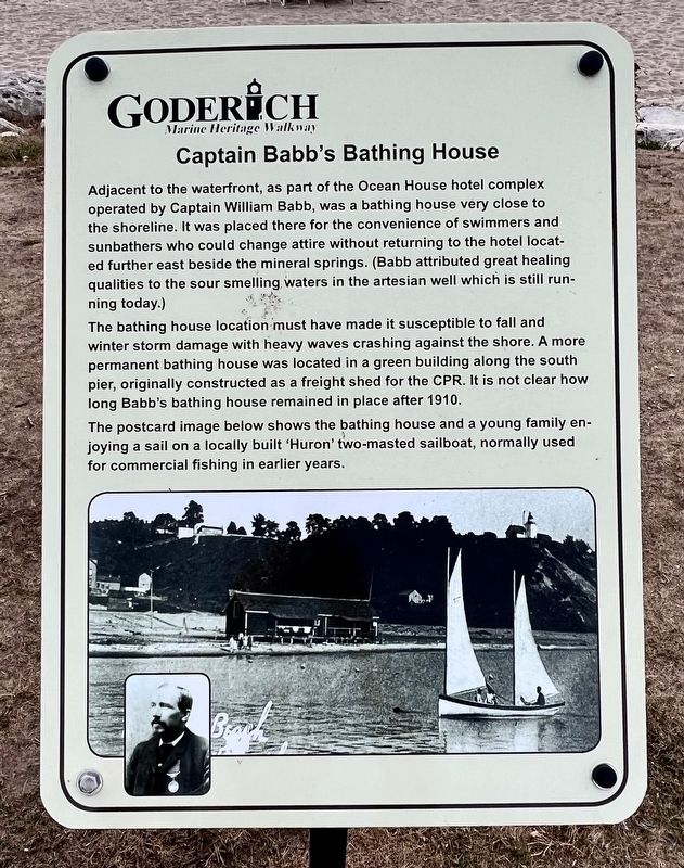
The bathing house location must have made it susceptible to fall and winter storm damage with heavy waves crashing against the shore. A more permanent bathing house was located in a green building along the south pier, originally constructed as a freight shed for the CPR. It is not clear how long Babb's bathing house remained in place after 1910.
The postcard image below shows the bathing house and a young family enjoying a sail on a locally built 'Huron' two-masted sailboat, normally used for commercial fishing in earlier years.
Topics. This historical marker is listed in this topic list: Parks & Recreational Areas. A significant historical year for this entry is 1910.
Location. 43° 44.628′ N, 81° 43.563′ W.
this page online

Regionally, this marker is in the Huron-Perth-Waterloo-Wellington Area and in Southwestern Ontario. It is also in Central Canada. Globally, it is in North America, on the Great Lakes, in the Western Hemisphere, in the Western World, and in the Anglosphere. Historically, it finds itself in what was once a British colony, the Viceroyalty of New France, the Haudenosaunee (Iroquois) Confederacy, and Rupert’s Land.
Other nearby markers. At least 8 other markers are within walking distance of this marker: Canada Company Piers (a few steps from this marker); Former Canadian Pacific Railway Station (about 90 meters away, measured in a direct line); Canadian Pacific Railroad Roundhouse (about 90 meters away); Imperial Oil Storage Tanks (about 120 meters away); The CPR Freight Shed (about 120 meters away); Goderich Harbour (about 120 meters away); The Waterworks
Photographed by Tim Boyd, August 22, 2025
2. Captains Babb’s Bathing House Marker
Credits. This page was last revised on August 27, 2025. It was originally submitted on August 26, 2025, by Tim Boyd of Hamilton, Ontario. This page has been viewed 107 times since then and 25 times this year. Photos: 1, 2. submitted on August 26, 2025, by Tim Boyd of Hamilton, Ontario. • Andrew Ruppenstein was the editor who published this page.
