Hespeler in Cambridge in Waterloo Region, Ontario — Central Canada (North America)
Tannery Street/ Forbes Park Area
Hespeler Village
Photographed by Tim Boyd, August 27, 2025
1. Tannery Street/ Forbes Park Area Marker
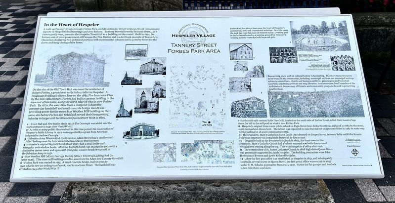
In the Heart of Hespeler
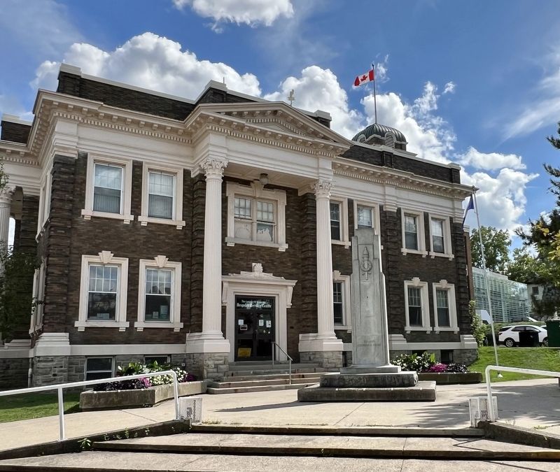
A walk up Tannery Street, through Forbes Park, and down Cooper Street to Queen Street reveals many aspects of Hespeler’s built heritage and civic history. Tannery street (formely Jackson street), as it curves gently west, presents the Hespeler Town Hall as a building-in-the-round. Built in 1914, the former seat of town government still houses the Fire Station and is a textbook example of Beaux-Arts Classicism displaying two pediment porticos with monumental columns and a 3-storey tower for the alarm and hang-drying of fire hoses.
On the site of the Old Town Hall was once the residence of Robert Forbes, a prominent early industrialist in Hespeler. A roughcast dwelling is shown here on the 1885 Fire Insurance Plan. By the mid-19th century, Forbes had built a tannery building in the area east of his home, along the north edge of what is now Forbes Park. By 1870, the waterflow from a millpond (where the present-day bandshell and small concrete bridge stand) was providing power for the stone Star Woollen Mill building on the same site before Forbes and Schofield moved their bourgeoning industry
this page online
Forbes Park has always been near the heart of Hespeler's commercial, civc and recreational activities. Over the years the park has been the place of children's play, a wading pool in the hot months and as a training ground for Hespeler’s winning athletic teams for both boys and girls.
Researching one's built or cultural history is fascinating. There are many resources to be found in any community, including: municipal archives and municipal heritage advisory committees; church and business archives, genealogical and historic societies; university archives and map libraries; local museums; local branches of the Architectural Conservancy of Ontario and community groups dedicated to preserving local heritage.
1 - Town Hall and Fire Station (built 1914). The Cenotaph was added near the north entrance in 1947 after World War II.
2 - As with so many public libraries built in this time period, the construction of Hespeler's Public Library in 1922 was supported by a grant from American industrialist Andrew Carnegie.
3 - Salvation Army Mission Hall (built 1902 on Adam Street)
Photographed by Tim Boyd, August 27, 2025
2. Tannery Street/ Forbes Park Area Marker
4 - Hespeler's original Baptist Church (built 1893) had a small belfry and triangular arch window heads. After the Baptist Church was enlarged in 1904 with a distinctive corner tower and again with triangular window heads it was sold to the Salvation Army in 1951.
5 - Star Woollen Mill (1870); Carriage Factory (1894); Universal Lighting Rod Co. (after 1947). This stone mill building could be seen from the Adam and Tannery Street hill.
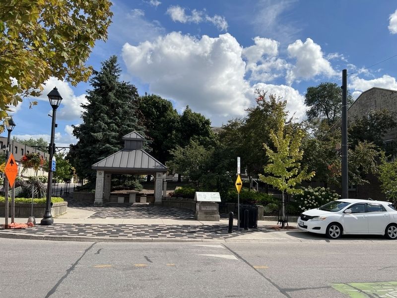
6 - Forbes Park was created in 1915. A small concrete bridge, built in 1925 to span what is now an underground creek, lead to Jawbone Street. The bandshell was erected in 1945 after World War II.
7 - In the mid-19th century Kribs' Saw Mill, located on the south side of Forbes Street, rolled their massive logs down the hill to the millpond in what is now Forbes Park.
8 - Hespeler's original three-room public school on Elgin Street (now Kribs Street) was replaced in 1882 by the stone, eight-room school shown here. The school was expanded in 1920 but did not escape demolition in 1982 to make way for the darking
Photographed by Tim Boyd, August 27, 2025
3. Hespeler Town hall/ Fire Station and Cenotaph, 2025
9 - The original St. Mary's Catholic Church (built 1857) fronted on Cooper Street, between Bella and Kribs Streets. This stone structure was completely destroyed by fire in 1916.
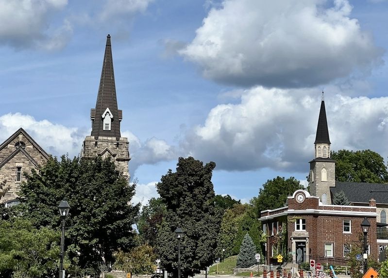
10 - Originally built as the Presbyterian Church in 1863, the front tower of the present St. Mary's Catholic Church had a belcast mansard roof with dormers and wrought iron cresting along the top. This was changed to a belfry after 1916.
11 - The construction of St. James Lutheran Church in 1868 high above Queen Street was generously supported by Jacob Hespeler. The building contractors were John Hoffmann of Preston and Lewis Kribs of Hespeler.
12 - After the first post office was established in Hespeler in 1851, and subsequently located in several stores on Queen Street, the last postal office was erected in 1929 under C. M. Schultz, postmaster from 1904-1927. Notice the flat parapet and no clock when this photo was taken.
Erected by Heritage Cambridge.
Topics. This historical marker is listed in these topic lists: Architecture • Parks & Recreational Areas • Religion & Religious Structures •
Photographed by Tim Boyd, August 27, 2025
4. Former Hespeler Post Office (bottom right) St. Andrew’s Church (left) and St. Mary’s Church (right)
Location. 43° 25.9′ N, 80° 18.582′ W. Marker is in Cambridge, Ontario, in Waterloo Region. It is in Hespeler. It is at the intersection of Queen Street East and Tannery Street East, on the right when traveling east on Queen Street East. Touch for map. Marker is at or near this postal address: 26 Queen Street E, Cambridge ON N3C 2A6, Canada. Touch for directions.

Regionally, this marker is in the Huron-Perth-Waterloo-Wellington Area and in Southwestern Ontario. It is also in Central Canada. Globally, it is in North America, the Western Hemisphere, the Western World, and the Anglosphere. Historically, it finds itself in what was once a British colony, the Viceroyalty of New France, the Haudenosaunee (Iroquois) Confederacy, and Rupert’s Land.
Other nearby markers. At least 8 other markers are within 6 kilometers of this marker, measured as the crow flies: Hespeler Cenotaph (within shouting distance of this marker); History of the Riverbank (about 120 meters away, measured in a direct line); Jacob’s Landing and Hespeler Mill Pond (about 180 meters away); First Mennonite Sunday School (approx. 2.1 kilometers away); Site of the Samuel Bechtel Meeting House and Burial Ground (approx. 2.3 kilometers away); Waterloo Township Community Meeting House School and Burial Ground (approx. 2.3 kilometers away); Black Bridge Road Bridge (approx. 2.3 kilometers away); The Settlement of Puslinch (approx. 5.1 kilometers away). Touch for a list and map of all markers in Cambridge.
Credits. This page was last revised on September 8, 2025. It was originally submitted on August 29, 2025, by Tim Boyd of Hamilton, Ontario. This page has been viewed 130 times since then and 58 times this year. Photos: 1, 2, 3, 4. submitted on August 29, 2025, by Tim Boyd of Hamilton, Ontario. • Andrew Ruppenstein was the editor who published this page.
