
Greenville in Norwich in Southeastern Region, Connecticut — The American Northeast (New England)
Miantonimo
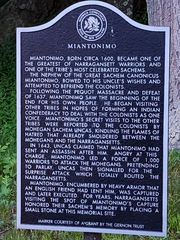
Photographed by Kristie Llanes, June 17, 2023
1. Miantonimo Marker
Miantonomo, born circa 1600, became one of the greatest of Narragansett warriors and one of the tribe's most celebrated sachems. The nephew of the great sachem Canonicus, Miantonomo bowed to his uncle's wishes and attempted to befriend the colonists.
Following the Pequot massacre and defeat of 1637, Miantonomo saw the beginning of the end for his own people. He began visiting other tribes in hopes of forming an Indian confederacy to deal with the colonists as one voice. Miantonomo's secret visits to the other tribes were reported to the colonists by Mohegan sachem Uncas, kindling the flames of hatred that already smoldered between the Mohegans and the Narragansetts.
In 1643, Uncas claimed that Miantonomo had sent an assassin after him. Angry at this charge, Miantonomo led a force of 1,000 warriors to attack the Mohegans. Pretending to parley, Uncas then signaled for the surprise attack which totally routed the Narragansetts.
Miantonomo, encumbered by heavy armor that an English friend had lent him, was captured and later executed. For years, Narragansetts visiting the spot of Miantonomo's capture honored
this page online
Erected by The Gernon Trust.
Topics. This historical marker is listed in this topic list: Indigenous Peoples and Communities. A significant historical year for this entry is 1600.
Location. 41° 32.962′ N, 72° 3.096′ W. Marker is in Norwich in Southeastern Region, Connecticut. It is in Greenville. It is on Elijah Street east of Boswell Avenue, on the left when traveling east. Touch for map. Marker is in this post office area: Norwich CT 06360, United States of America. Touch for directions.

Regionally, this marker is on the Connecticut Shoreline, in Greater New London and in the Thames River Valley. It is also in the American Northeast and in New England. Globally, it is in the North Atlantic Region, North America, the Western Hemisphere, the Western World, and the Anglosphere. Historically, it finds itself in what was once New London County and also one of the original Thirteen Colonies.
Other nearby markers. At least 8 other markers are within 2 miles of this marker, measured as the crow flies: John F. Slater (approx. 1.8 miles away); The Shattuck Building (approx. 1.8 miles away); William Ashby McCloy (approx. 1.8 miles away); Dr. Charles H. Osgood Fountain (approx. 1.8 miles away); Slater Museum (approx. 1.8 miles away); U.S.S. Maine Memorial (approx. 1.8 miles away); Benedict Arnold (approx. 1.8 miles away); Veterans Dedication Stone (approx. 1.9 miles away). Touch for a list and map of all markers in Norwich.
Credits. This page was last revised on May 19, 2026. It was originally submitted on August 30, 2025. This page has been viewed 93 times since then and 12 times this year. Photo 1. submitted on August 30, 2025, by Kristie Llanes of Griswold, Connecticut. • Michael Herrick was the editor who published this page.
Editor’s want-list for this marker. A wide view photo of the marker and its surroundings & a photo of the memorial boulder. • Can you help?
