Near New Town in Mountrail County, Montana — The American West (Mountains)
Pouch Point Recreation Area
Lewis and Clark in North Dakota
Photographed by Barry Swackhamer, July 23, 2025
1. Pouch Point Recreation Area Marker
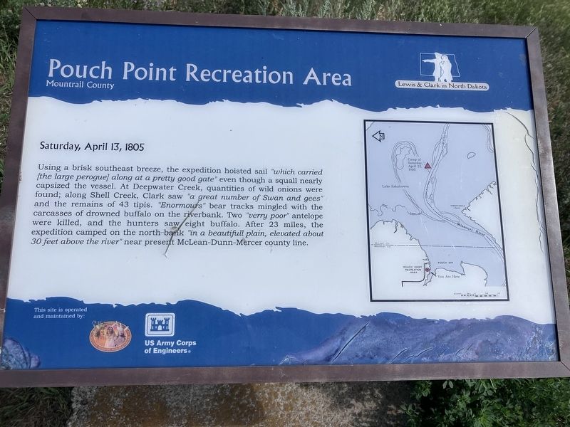
Using a brisk southeast breeze, the expedition hoisted sail "which carried [the large peroquel] along at a pretty good rate" even though a squall nearly capsized the vessel. At Deepwater Creek, quantities of wild onions were found; along Shell Creek, Clark saw "a great number of Swan and gees" and the remains of 43 tipis. Enormours" bear tracks mingled with the carcasses of drowned buffalo on the riverbank. Two "verry poor" antelope were killed, and the hunters saw eight buffalo. After 23 miles, the expedition camped on the north bank "in a beautifull plain, elevated about 30 feet above the river" near present McLean-Dunn-Mercer county line.
Erected by Three Affiliated Tribes (MHA), US Army Corps of Engineers.
Topics and series. This historical marker is listed in these topic lists: Exploration • Waterways & Vessels. In addition, it is included in the Lewis & Clark Expedition series list. A significant historical date for this entry is April 13, 1805.
Location. 47° 48.166′ N, 102° 24.538′ W. Marker is near New Town, Montana, in Mountrail County. It can be reached from Pouch Point Road near 28th
this page online

Regionally, this marker is in the American Mountain West and in the Lewis & Clark Corridor. Globally, it is in North America, the Western Hemisphere, the Western World, and the Anglosphere. Historically, it finds itself in what was once Rupert’s Land and also the Louisiana Purchase.
Other nearby markers. At least 4 other markers are within 14 miles of this marker, measured as the crow flies: The Best of the West (approx. 13.9 miles away in North Dakota); Crow Flies High (approx. 13.9 miles away in North Dakota); Pe-Ri-Tska-Wa-Ku-Re (approx. 13.9 miles away in North Dakota); Old Sanish Townsite (approx. 13.9 miles away in North Dakota).
Photographed by Barry Swackhamer, July 23, 2025
2. Pouch Point Recreation Area Marker
Credits. This page was last revised on September 12, 2025. It was originally submitted on August 31, 2025, by Barry Swackhamer of Brentwood, California. This page has been viewed 101 times since then and 24 times this year. Photos: 1, 2. submitted on August 31, 2025, by Barry Swackhamer of Brentwood, California.
