Beersheba Springs in Grundy County, Tennessee — The American South (East South Central)
Forrest's Murfreesboro Raid
July 10, 1862
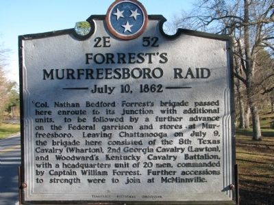
Photographed by Tom Gillard, December 27, 2009
1. Forrest's Murfreesboro Raid Marker
Erected 2008 by Tennessee Historical Commission. (Marker Number 2E 52.)
Topics and series. This historical marker is listed in this topic list: War, US Civil. In addition, it is included in the Tennessee Historical Commission series list. A significant historical date for this entry is July 1, 1837.
Location. Marker is missing. It was located near 35° 27.891′ N, 85° 39.23′ W. Marker was in Beersheba Springs, Tennessee, in Grundy County. It was on Jaycee Drive/Rivers Landing Road (Tennessee Route 56) 0.2 miles Cedar Avenue (Route 72), on the right. Touch for map. Marker was at or near this postal address: 838 W Main St, Beersheba Springs TN 37305,
this page online

Regionally, this marker was in Tennessee’s Cumberland Plateau and in the Highland Rim. It was also in the American South, specifically in the Upper South, in Appalachia, and specifically in Southern Appalachia. Globally, it was in North America, the Western Hemisphere, the Western World, and the Anglosphere. Historically, it found itself in what was once the territory of the Mississippian Culture, one of the Confederate States of America, and the Antebellum South.
Other nearby markers. At least 8 other markers are within 5 miles of this location, measured as the crow flies: Beersheba Inn (within shouting distance of this marker); Mary Noailles Murfree (about 700 feet away, measured in a direct line); Welcome to Beersheba Springs (approx. 0.7 miles away); Beersheba Springs Historic District (approx. 0.7 miles away); Veterans Memorial (approx. 0.7 miles away); Greeter Homeplace (approx. 3 miles away); Long’s Mill and the Chickamauga Trace (approx. 3.2 miles away); L.V. Woodlee House (approx. 4½ miles away). Touch for a list and map of all markers in Beersheba Springs.
Credits. This page was last revised on September 5, 2025. It was originally submitted on December 27, 2009, by Tom Gillard of Tullahoma, Tennessee. This page has been viewed 1,473 times since then and 35 times this year. Last updated on August 31, 2025, by Edward Troxel of Creal Springs, Illinois. Photo 1. submitted on December 27, 2009, by Tom Gillard of Tullahoma, Tennessee. • Bernard Fisher was the editor who published this page.
