Windsor in Hartford County, Connecticut — The American Northeast (New England)
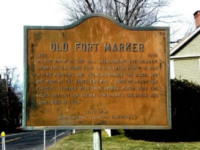
Old Fort Marker
1633 - 1933
Erected by D.A.R. Abigail Wolcott Ellsworth Chapter.
Topics and series. This historical marker is listed in these topic lists: Colonial Era • Forts and Castles • Native Americans • Notable Buildings • Settlements & Settlers. In addition, it is included in the Daughters of the American Revolution series list. A significant historical year for this entry is 1809.
Location. 41° 52.241′ N, 72° 37.691′ W. Marker is in Windsor, Connecticut, in Hartford County. Marker is on Connecticut Route 159. Touch for map. Marker is at or near this postal address: 545 Palisado Avenue, Windsor, CT, Windsor CT 06095, United States of America. Touch for directions.
Other nearby markers. At least 8 other markers are within 2 miles of this marker, measured as the crow flies. Windsor Pilgrims (within shouting distance of this marker); Bissell's Ferry (approx. 0.3 miles away); Birthplace of Oliver Ellsworth (approx. 0.6 miles away); Bissell Ferry (approx. ¾ mile away); Founders Of Windsor (approx. one mile away); Major John Mason (approx. one mile away); Horace H. Hayden, M.D.,D.D.S. (approx. one mile away); Windsor Train Station (approx. 1½ miles away). Touch for a list and map of all markers in Windsor.
Credits. This page was last revised on June 16, 2016. It was originally submitted on March 8, 2010, by Antonio Prats of Shrewsbury, Massachusetts. This page has been viewed 1,276 times since then and 30 times this year. Photo 1. submitted on March 8, 2010, by Antonio Prats of Shrewsbury, Massachusetts. • Bill Pfingsten was the editor who published this page.
