McLean in Fairfax County, Virginia — The American South (Mid-Atlantic)
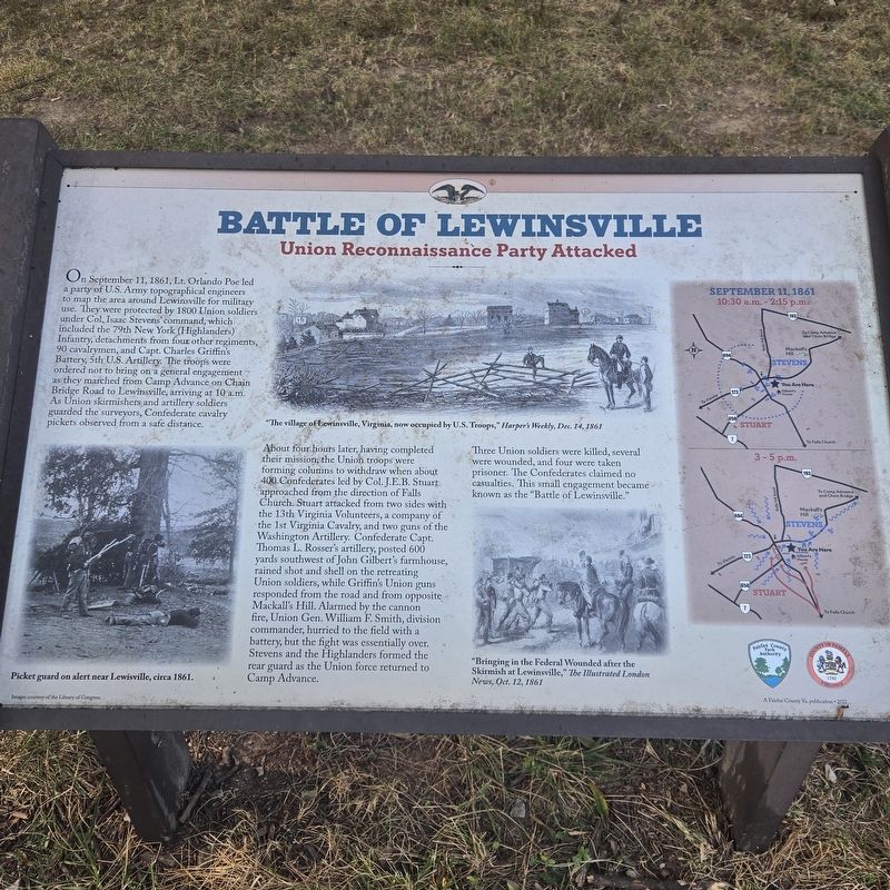
Battle of Lewinsville
Union Reconnaissance Party Attacked
Photographed by Mike McKeown, September 6, 2025
1. Battle of Lewinsville Marker
About four hours later, having completed their mission, the Union troops were forming columns to withdraw when about 400 Confederates led by Col. J.E.B. Stuart approached from the direction of Falls Church. Stuart attacked from two sides with the 13th Virginia Volunteers, a company of the 1st Virginia Cavalry, and two guns of the Washington Artillery. Confederate Capt. Thomas L. Rosser's artillery, posted 600 yards southwest of John Gilbert's farmhouse, rained shot
this page online
Three Union soldiers were killed, several were wounded, and four were taken prisoner. The Confederates claimed no casualties. This small engagement became known as the "Battle of Lewinsville."
(captions)
Picket guard on alert near Lewisville, circa 1861. Images courtesy of the Library of Congress.
"The village of Lewinsville, Virginia, now occupied by U.S. Troops," Harper's Weekly, Dec. 14,1861
"Bringing in the Federal Wounded after the Skirmish at Lewinsville," The Illustrated London News, Oct. 12, 1861
Erected by Fairfax County Park Authority.
Topics. This historical marker is listed in this topic list: War, US Civil. A significant historical date for this entry is September 11, 1861.
Location. 38° 55.69′ N, 77° 11.467′ W. Marker is in McLean, Virginia, in Fairfax

Photographed by Mike McKeown, September 6, 2025
2. Battle of Lewinsville Marker
Marker area

Regionally, this marker is in the Washington Metropolitan Area and in Northern Virginia. It is also in the American South, specifically in the Upper South, in the Mid-Atlantic, and on the Eastern Seaboard. Globally, it is in the North Atlantic Region, North America, the Western Hemisphere, the Western World, and the Anglosphere. Historically, it finds itself in what was once the territory of the Mississippian Culture, one of the original Thirteen Colonies, one of the Confederate States of America, and the Antebellum South.
Other nearby markers. At least 8 other markers are within 2 miles of this marker, measured as the crow flies: William Whann Mackall (approx. 0.4 miles away); McLean Volunteer Firehouse (approx. ¾ mile away); The Laughlin Building (approx. 0.8 miles away); McLean (approx. 0.8 miles away); Benvenue

Photographed by Mike McKeown, September 6, 2025
3. Battle of Lewinsville Marker
Sign for Lewinsville park near Chain Bridge Road
Another marker is no longer nearby. Battle of Lewinsville (has been replaced with this marker).
Related marker. Click here for another marker that is related to this marker. Old CWT Marker At This Location also titled "Battle of Lewinsville".
Also see . . .
1. Battle of Lewinsville (Wikipedia). (Submitted on September 6, 2025, by Mike McKeown of Baltimore, Maryland.)
2. Isaac Stevens (Wikipedia). (Submitted on September 6, 2025, by Mike McKeown of Baltimore, Maryland.)
3. Charles Griffin (Wikipedia). (Submitted on September 6, 2025, by Mike McKeown of Baltimore, Maryland.)
Credits. This page was last revised on September 6, 2025. It was originally submitted on September 6, 2025, by Mike McKeown of Baltimore, Maryland. This page has been viewed 810 times since then and 71 times this year. Photos: 1, 2, 3. submitted on September 6, 2025, by Mike McKeown of Baltimore, Maryland. • Bernard Fisher was the editor who published this page.
