
Niagara Falls in Niagara Region, Ontario — Central Canada (North America)
Willoughby Church Cemetery
Photographed by Kevin Westell, September 17, 2025
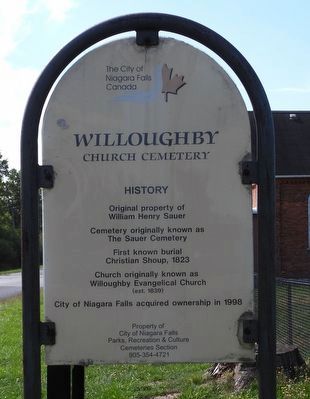
1. Willoughby Church Cemetery - Marker
The City of Niagara Falls Canada
Willoughby Church Cemetery
History
Original property of William Henry Sauer
Cemetery originally known as The Sauer Cemetery
First known burial Christian Shoup, 1823
Church originally known as Willoughby Evangelical Church (est. 1839)
City of Niagara Falls acquired ownership in 1998
Property of City of Niagara Falls Parks, Recreation & Culture Cemeteries Section 905-354-4721
Erected by City of Niagara Falls.
Topics. This historical marker is listed in these topic lists: Cemeteries & Burial Sites • Religion & Religious Structures. A significant historical year for this entry is 1823.
Location. 42° 59.424′ N, 79° 4.19′ W. Marker is in Niagara Falls, Ontario, in Niagara Region. It is at the intersection of Ort Road and Sauer Road, on the right when traveling south on Ort Road. Touch for map. Marker is at or near this postal address: 13111 Ort Road, Niagara Falls ON L2E 6S6, Canada. Touch for directions.

Regionally, this marker is on Ontario’s Golden Horseshoe and in Niagara Canada. It is also in Central Canada. Globally, it is in
this page online
Other nearby markers. At least 8 other markers are within 5 kilometers of this marker, measured as the crow flies: A different marker also named Willoughby Church Cemetery (here, next to this marker); Strickler-Danner House circa 1805 (approx. 3.4 kilometers away); Ebenezer Community (approx. 3.5 kilometers away); Location of the Ebenezer Settlement 1848 1858 (approx. 3.8 kilometers away); Conestoga Wagon Trek (approx. 3.8 kilometers away); Disaster at Eagle Park (approx. 4.9 kilometers away in the U.S.); Lyon's Creek Cemetery (approx. 4.9 kilometers away); White Oak at Lyon's Creek Cemetery (approx. 4.9 kilometers away). Touch for a list and map of all markers in Niagara Falls.
Photographed by Kevin Westell, September 17, 2025
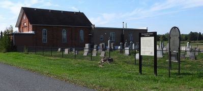
2. Willoughby Church Cemetery
Photo faces south-west from Ort Rd. Sauer Rd runs behind the church.
Photographed by Kevin Westell, September 17, 2025
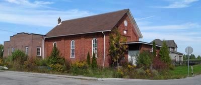
3. Sustainable Christian Ministry
Formerly, Willoughby Evangelical United Brethren Church.
Later, Willoughby United Church.
Credits. This page was last revised on September 18, 2025. It was originally submitted on September 18, 2025, by Kevin Westell of St. Catharines, Ontario. This page has been viewed 40 times since then and 13 times this year. Photos: 1, 2, 3. submitted on September 18, 2025, by Kevin Westell of St. Catharines, Ontario. • Andrew Ruppenstein was the editor who published this page.
