Mountain View in Clayton County, Georgia — The American South (South Atlantic)
Rough and Ready Tavern
>>>------>
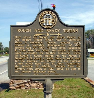
Photographed by David Seibert, April 12, 2009
1. Rough and Ready Tavern Marker
Erected 1954 by Georgia Historical Commission. (Marker Number 031-2.)
Topics and series. This historical marker is listed in these topic lists: Railroads & Streetcars • War, US Civil. In addition, it is included in the Georgia Historical Society series list. A significant historical date for this entry is August 30, 1864.
Location. Marker is missing. It was located near 33° 38.752′ N, 84° 23.418′ W. Marker was in Mountain View, Georgia, in Clayton County. It was on Old Dixie Highway (U.S. 41 at milepost 16), 0.1 miles north of Conley Road,
this page online

Regionally, this marker was in Georgia’s Piedmont and in Metro Atlanta. It was also in the American South and specifically in the Deep South. Globally, it was in North America, the Western Hemisphere, the Western World, and the Anglosphere. Historically, it found itself in what was once the territory of the Mississippian Culture, one of the original Thirteen Colonies, one of the Confederate States of America, and the Antebellum South.
Other nearby markers. At least 8 other markers are within 2 miles of this location, measured as the crow flies: Dwarf Grill (approx. 1.1 miles away); Chick-fil-A (approx. 1.1 miles away); The Dwarf House (approx. 1.1 miles away); Hapeville Veterans Memorial (approx. 1.4 miles away); Im Memory of the Hapeville Boys (approx. 1.4 miles away); Hapeville Veterans Monument (approx. 1.4 miles away); Hapeville, Georgia (approx. 1.4 miles away); Ga. Baptist Children's Home (approx. 1½ miles away). Touch for a list and map of all markers
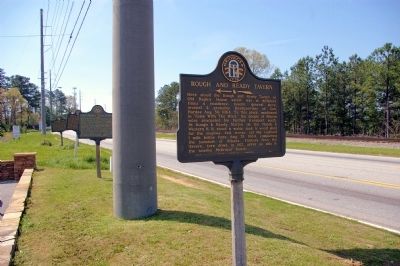
Photographed by David Seibert, April 12, 2009
2. Rough and Ready Tavern Marker
In the background, looking south on Old Dixie Highway, are the Jonesboro Threatened, Rough and Ready, and Transfer Point markers.
Other markers no longer nearby. Jonesboro Threatened (was a few steps from this marker but has been confirmed missing); Rough and Ready (was a few steps from this marker but has been confirmed missing); Transfer Point (was a few steps from this marker but has been confirmed missing).
More about this marker. Marker is .1 south of the Fulton County line.
Regarding Rough and Ready Tavern. Federal troops cutting the railroad south of Rough and Ready, mentioned on the marker, was one of the most important actions in the Battle of Atlanta. With this act all railroads supplying Atlanta had been cut, leaving Confederate General John Bell Hood no option but to abandon the city with his troops. They blew up all the munitions and supplies they couldn't carry; this was one of the most remembered scenes in "Gone with the Wind."
Also see . . . Rough and Ready. Georgia Historical Society reports the marker is not present
*Marker not in place due to damage or maintenance.(Submitted on September 19, 2025, by Mark Parker of Hickory, North Carolina.)
Additional commentary.
1. Four Markers Missing?
While trying to look on Google streetview (as of Nov 2016) of this alignment of many markers along U.S. 41, I was unable to see any of them. Can anyone please verify these markers still are here?
— Submitted March 2, 2017, by Mark Hilton of Montgomery, Alabama.
Credits. This page was last revised on September 20, 2025. It was originally submitted on April 27, 2009, by David Seibert of Sandy Springs, Georgia. This page has been viewed 4,754 times since then and 77 times this year. Last updated on September 19, 2025, by Mark Parker of Hickory, North Carolina. Photos: 1, 2. submitted on April 27, 2009, by David Seibert of Sandy Springs, Georgia. • Bernard Fisher was the editor who published this page.
