
Near Garrison in McLean County, North Dakota — The American Midwest (Upper Plains)
Geology
Indian Hills
Photographed by Barry Swackhamer
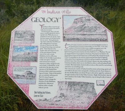
1. Geology Marker
Captions: (left side, top to bottom) (unable to read); Colorful reddish layers of "clinker" or scoria.; Layers of windblown ash and sediments deposited by ancient rivers turned over time into sandstone, coal, siltstone, and mudstone layers.
Overlooking the valley is the drift prairie, covered by glacial till, which is equally fertile. Within the river are found bars of sand , silt, and clay, which has been transported and deposited by the river waters. During the last Ice Abe, which ended about 10,000 years ago, melting glaciers forced great amounts of water down the valley, moving and depositing coarse sand and gravel. Terrace deposits in the modern valley show lenses of some of this sand and gravel. During times of low water on Lake Sakakawea, the feet of the steep banks and the shoreline are good places to hike and explore. Chunks of coal, fossilized tree remnants, concretions, clinker, and glacial rocks can be found. At Beulah Bay, on the south side of the lake, there are fine exposures of the Sentinel Butte formation which contain many petrified logs and stumps. Some of the petrified trees are extremely well preserved. The US Army Corps of Engineers, which manages the shoreline of Lake Sakakawea, prohibits the collection of artifacts, rocks, or fossils without
this page online
Also to be seen are a number of buttes, formed by erosion and surviving caprice, and noticeable for the many

Photographed by Barry Swackhamer
2. Geology Marker
Take Nothing but Pictures, Leave no Trace
Erected by Indian Hills Resort.
Topics. This historical marker is listed in this topic list: Natural Features.
Location. 47° 36.045′ N, 102° 5.768′ W. Marker is near Garrison, North Dakota, in McLean County. It can be reached from the intersection of 73rd Avenue NorthWest and 14th Street NorthWest. The marker is located on the Nux Baa Ga (meaning “All the People” in Arikara) Trail. Touch for map. Marker is in this post office area: Garrison ND 58540, United States of America. Touch for directions.

Regionally, this marker is in North Dakota’s Mandan, Hidatsa, and Arikara Nation, in the Standing Rock Sioux Tribe, in the Drift Prairie, and on the Missouri Plateau. It is also in the American Lewis & Clark Corridor, on the prairies, and on the Northern Plains. Globally, it is in North America, the Western Hemisphere, the Western World, and the Anglosphere. Historically, it finds itself in what was once Rupert’s Land and also the Louisiana Purchase.
Other nearby markers. At least 8 other markers are within walking distance of this marker: Nightwalker's Butte (about 600 feet away, measured in a direct line); a different marker also named Nightwalker's Butte (about 600 feet away); Lewis & Clark (approx. 0.2 miles away); Sakakawea (approx. 0.2 miles away); Lake Sakakawea (approx. 0.2 miles away); Four Bears Bridge (approx. 0.2 miles away); Contemporary Towns (approx. 0.2 miles away); Encampments (approx. 0.2 miles away). Touch for a list and map of all markers in Garrison.
Credits. This page was last revised on September 24, 2025. It was originally submitted on September 24, 2025, by Barry Swackhamer of Brentwood, California. This page has been viewed 64 times since then and 31 times this year. Photos: 1, 2. submitted on September 24, 2025, by Barry Swackhamer of Brentwood, California.
