
Omaha in Douglas County, Nebraska — The American Midwest (Upper Plains)
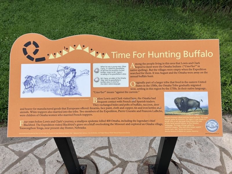
Time For Hunting Buffalo
Photographed by Barry Swackhamer, July 16, 2025
1. Time For Hunting Buffalo Marker
Caption: (bottom right) Omaha hunters observed the lead buffalo, Te-nuga zing gaha-ta nonzhin for signs it was ready to break into a run because they knew the rest of the herd would follow. In the Omaha language, Te-nuga zing gaha-ta nonzhin means "the one who keeps watch." George Catlin, 1850, "Buffalo Bull Grazing"
Originally part of a larger tribe that lived in the eastern United States in the 1500s, the Omaha Tribe gradually migrated west, settling in this region by the 1750s. In their native language, "Umonhon" means "against the current.
Before Lewis and Clark visited here, the Omaha had frequent contact with French and Spanish traders. They exchanged hides and pelts of buffalo, raccoon, deer and beaver for manufactured goods that Europeans offered; firearms, face paint, cloth, and copper, tin and iron kettles and utensils. White trappers also married into the tribe. Two members of the Expedition, Pierre Cruzatte and Francois LaBiiche, were children of Omaha women who married French trappers.
Four years before Lewis and Clark's journey, a smallpox epidemic killed 400 Omaha, including the legendary chief Blackbird. The Expedition visited Blackbird's grave on
this page online
Erected by National Park Service, City of Omaha, Papio-Missouri River Natural Resources District.
Topics. This historical marker is listed in these topic lists: Exploration • Indigenous Peoples and Communities.
Location. 41° 16.241′ N, 95° 55.197′ W. Marker is in Omaha, Nebraska, in Douglas County. It is on Gallup Drive near Freedom Park Road, on the left when traveling south. Touch for map. Marker is at or near this postal address: 1001 Gallup Drive, Omaha NE 68101, United States of America. Touch for directions.

Regionally, this marker is in Eastern Nebraska. It is also in the American Midwest, in the Lewis & Clark Corridor, in the Corn Belt, and on the prairies. Globally, it is in North America, the Western Hemisphere, the Western World, and the Anglosphere. Historically, it finds itself in what was once the Louisiana Purchase.
Other nearby markers. At least 8 other markers are within walking distance of this marker: First Formal Exchange (here,
Photographed by Barry Swackhamer, July 16, 2025
2. Time For Hunting Buffalo Marker
More about this marker. There is an audio component to this marker. Select a button and listen to "When he was a young man, Oliver Cayou, Sr. asked his grandfather to tell how his ancestors hunted buffalo, Listen to Mr. Cayou's re-telling of his grandfather's story." or "Mr. Cayou, an elder of the Omaha tribe, tells his grandfather's buffalo story in Umonhonm the tribe's native language."
Credits. This page was last revised on October 14, 2025. It was originally submitted on October 14, 2025, by Barry Swackhamer of Brentwood, California. This page has been viewed 63 times since then and 36 times this year. Photos: 1, 2. submitted on October 14, 2025, by Barry Swackhamer of Brentwood, California.
