Rockville Centre in Nassau County, New York — The American Northeast (Mid-Atlantic)
The Rev. Dr. Morgan Days Park
Photographed by Ian Lefkowitz, October 15, 2025
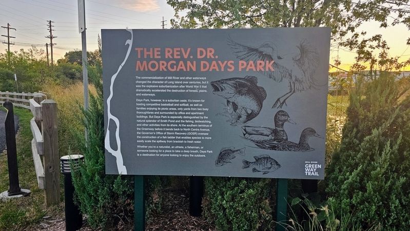
1. The Rev. Dr. Morgan Days Park Marker
The commercialization of Mill River and other waterways changed the character of Long Island over centuries, but it was the explosive suburbanization after World War II that dramatically accelerated the destruction of forests, plains, and waterways.
Days Park, however, is a suburban oasis. It's known for hosting competitive basketball and softball, as well as families enjoying its picnic areas, only yards from two busy thoroughfares and surrounded by office and apartment buildings. But Days Park is especially distinguished by the natural splendor of Smith Pond and the fishing, birdwatching, and other activities from its shore. At the southern terminus of the Greenway before it bends back to North Centre Avenue, the Governor's Office of Storm Recovery (GOSR) oversaw the construction of a fish ladder that enables species to more easily scale the spillway from brackish to fresh water.
Whether you're a naturalist, an athlete, a fisherman, or someone looking for a place to take a deep breath, Days Park is a destination for anyone looking to enjoy the outdoors.
Topics. This historical marker is listed in this topic list:
this page online
Location. 40° 39.549′ N, 73° 39.169′ W. Marker is in Rockville Centre, New York, in Nassau County. It is on Nassau Street west of Claude Street. Touch for map. Marker is at or near this postal address: 51 Nassau Street, Rockville Centre NY 11570, United States of America. Touch for directions.

Regionally, this marker is in the New York City Metropolitan Area and on Long Island. It is also in the American Northeast, in the Mid-Atlantic, and on the Eastern Seaboard. Globally, it is in the North Atlantic Region, North America, the Western Hemisphere, the Western World, and the Anglosphere. Historically, it finds itself in what was once New Netherland and also one of the original Thirteen Colonies.
Other nearby markers. At least 8 other markers are within walking distance of this marker: English Laws and the Native American Experience (within shouting distance of this marker); The History of Rockville Centre's Smith Pond (about 400 feet away, measured in a direct line); The Civil Rights Conscience of the Community (approx. 0.2 miles away); A Sacred and Significant Landmark

Photographed by Ian Lefkowitz, October 15, 2025
2. The Rev. Dr. Morgan Days Park Marker
The marker is part of a series at the southern entrance of Days Park.
More about this marker. The marker is located at the southern entrance to The Rev. Dr. Morgan Days Park. An identical marker is located at the northern entrance.

Photographed by Ian Lefkowitz, October 15, 2025
3. Birds of All Feathers Marker
An environmental marker highlighting birdwatching along Mill River.

Photographed by Ian Lefkowitz, October 15, 2025
4. American Eels Marker
An environmental marker describing the life cycle of the American eel in Mill River.
Credits. This page was last revised on October 24, 2025. It was originally submitted on October 19, 2025, by Ian Lefkowitz of New York, New York. This page has been viewed 62 times since then and 37 times this year. Photos: 1, 2, 3, 4. submitted on October 19, 2025, by Ian Lefkowitz of New York, New York. • Andrew Ruppenstein was the editor who published this page.
