Black Hawk in Gilpin County, Colorado — The American Mountains (Southwest)
Black Hawk History - Main Street
Photographed by Leslie Eudy
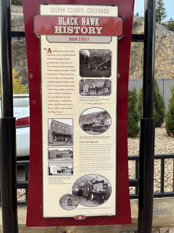
1. Black Hawk History - Main Street Marker
Gilpin County, Colorado
Black Hawk History
Main Street
“A sudden turn in the road discloses a view of Black Hawk, with its charming church perched above the town, on the extremity of the headland which separates Gregory Gulch from that of Clear Creek. We at once entered a busy, noisy, thickly populated region. The puff of steam, the dull thump of the stamp mills, and all the other sounds of machinery at work, filled the air; the road became a continuous street, with its hotels, stores, livery stables, and crowded dwelling houses.” Bayard Taylor, Colorado: A Summer Trip, 1867.
City of Mills
Clear Creek’s northern branch marked the entry into Black Hawk. The land along the creek as well as the ready access to abundant water encouraged the proliferation of milling operations, the building of roads and the railroad. Clearing, grading, and the maintenance of the early unpaved roads became the work of private businesses who charged a toll for the use of the road.
The historic entry along Clear Creek into Black Hawk’s Main Street, paralleling Highway 119 (also known as Depot Road), is now home to a large concentration
this page online
Many of the earlier community structures—the railroad depot and tracks, the Toll Gate Saloon, the neighborhood of homes and businesses clustered around the Lace House and the Gilpin Hotel as well as Clear Creek itself—no longer exist, or fortuitously have been moved to different locations.
Topics. This historical marker is listed in these topic lists: Industry & Commerce • Roads & Vehicles • Settlements & Settlers.
Location. 39° 48.034′ N, 105° 29.532′ W. Marker is in Black Hawk, Colorado, in Gilpin County. It is on Main Street, on the left when traveling north. Marker is on Main Street. When heading north on Highway 119, take a left on Main Street. Marker is past the Lodge Casino near the end of the parking area on the left. Touch for map. Marker is in this post office area: Black Hawk CO 80422, United States of America. Touch for directions.

Regionally, this marker is in the Colorado High Rockies. It is also in the American Mountain West. Globally, it is in North America, the Rocky Mountains, the Western Hemisphere, the Western World, and

Photographed by Leslie Eudy, October 24, 2025
2. Black Hawk History - Main Street Marker wide area
Other nearby markers. At least 8 other markers are within walking distance of this marker: Black Hawk History - Business (within shouting distance of this marker); Gilpin Hotel (about 500 feet away, measured in a direct line); Fick’s Carriage Shop (about 600 feet away); Black Hawk History (about 600 feet away); Bird’s-eye view of Black Hawk (about 600 feet away); Jenkins McKay Hardware (about 800 feet away); Train Trestle (approx. 0.2 miles away); Black Hawk History - Floods (approx. 0.2 miles away). Touch for a list and map of all markers in Black Hawk.

Photographed by Leslie Eudy, October 24, 2025
3. Smelting Works and Lace House Photos
(Top): View of Boston and Colorado Smelting Works, ca 1880. (Bottom): Northeast elevation of The Lace House, Main Street. Built in 1863, the lavish decorative wood detail shows off the best of Carpenter Gothic architecture.

Photographed by Leslie Eudy, October 24, 2025
4. Lace House along Railroad Photo
Looking south along two sets of the Colorado Central Railroad train tracks which ran parallel to North Clear Creek, ca. 1920. Lace House, to the right of the railcar was built in 1963 and is still standing.

Photographed by Leslie Eudy, October 24, 2025
5. Gilpin Hotel Photos
(Top): View of the Gilpin Hotel, Main Street, built in the mid-1890s. This brick hotel replaced an earlier wood building that housed the first town newspaper and the public school, ca. 1900.
(Middle): The Gilpin Hotel, Main Street, ca. 1940s.
(Bottom): The Gilpin Hotel & The Mine Shaft Bar, Main Street, ca. 1958.

Photographed by Leslie Eudy, October 24, 2025
6. Toll Gate Saloon Photos
(Left): Toll Gate Saloon, Main Street, ca. 1940s; demolished. (Above): Interior view of the Toll Gate Saloon, ca. 1897.
Credits. This page was last revised on November 2, 2025. It was originally submitted on October 29, 2025, by Leslie Eudy of Golden, Colorado. This page has been viewed 69 times since then and 35 times this year. Photos: 1, 2, 3, 4, 5, 6. submitted on October 29, 2025, by Leslie Eudy of Golden, Colorado. • Andrew Ruppenstein was the editor who published this page.
