Eastport in Annapolis in Anne Arundel County, Maryland — The American Northeast (Mid-Atlantic)
Eastport's Old Main Street
| — | Eastport Walking Tour | — |
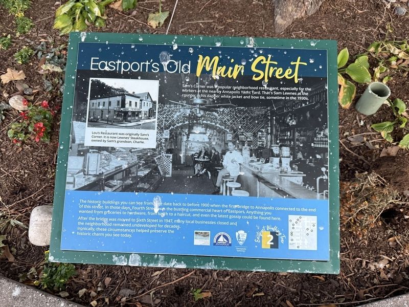
The historic buildings you can see from here date back to before 1900 when the first bridge to Annapolis connected to the end of this street. In those days, Fourth Street was the bustling commercial heart of Eastport. Anything you wanted from groceries to hardware, from lunch to a haircut, and even the latest gossip could be found here.
After the bridge was moved to Sixth Street in 1947, many local businesses closed and the neighborhood remained undeveloped for decades. Ironically, these circumstances helped preserve the historic charm you can see today.
[Captions:]
Lou's Restaurant was originally Sam's Corner. It is now Lewnes' Steakhouse, owned by Sam's grandson, Charlie.
Sam's Corner was a popular neighborhood restaurant, especially for the workers at the nearby Annapolis Yacht Yard. That's Sam Lewnes at the counter in his dapper white jacket and bow tie, sometime in the 1930s.
Erected by Annapolis, London Town & South County Heritage Area, Inc.; Annapolis Maritime Museum & Park; Chesapeake Gateways Network. (Marker Number 2.)
Topics. This historical marker is listed in these topic lists: Industry & Commerce
this page online
Location. 38° 58.326′ N, 76° 28.989′ W. Marker is in Annapolis, Maryland, in Anne Arundel County. It is in Eastport. It is on Fourth Street north of Severn Avenue, on the left when traveling north. Touch for map. Marker is at or near this postal address: 301 Fourth St, Annapolis MD 21403, United States of America. Touch for directions.

Regionally, this marker is in Central Maryland. It is also in the American Mid-Atlantic, in the Chesapeake Bay Region, and on the Eastern Seaboard. Globally, it is in the North Atlantic Region, North America, the Western Hemisphere, the Western World, and the Anglosphere. Historically, it finds itself in what was once one of the original Thirteen Colonies and also the Antebellum South.
Other nearby markers. At least 8 other markers are within walking distance of this marker: A different marker also named A Tale of Three Bridges (a few steps from this marker); Arnold C. Gay (a few steps from this marker); a different marker also named Three Great Boat Yards, One Location (about 600 feet away);
Other markers no longer nearby. Eastport's Old "Main Street" (was here, next to this marker but has been replaced with another marker now near it); A Tale of Three Bridges (was here, next to this marker but has been replaced with another marker now near it); Three Great Boat Yards, One Location (was about 600 feet away, measured in a direct line but has been replaced with another marker now near it); On to Yorktown (was about 600 feet away but has been permanently removed); Welcome to Eastport (was about 600 feet away but has been replaced with another marker now near it); The Glass Works (was approx. 0.2 miles away but has been replaced with another marker now near it).
Credits. This page was last revised on October 29, 2025. It was originally submitted on October 29, 2025, by Devry Becker Jones of Washington, District of Columbia. This page has been viewed 74 times since then and 35 times this year. Photos: 1, 2. submitted on October 29, 2025, by Devry Becker Jones of Washington, District of Columbia.
