Near Doswell in Hanover County, Virginia — The American South (Mid-Atlantic)
Hanover Junction
Crucial Intersection
| — | Lee vs. Grant — The 1864 Campaign | — |
Photographed by Bill Coughlin, April 21, 2007
1. Hanover Junction Civil War Trails marker
This marker is part of the Lee vs Grant - The 1864 Campaign of the Virginia Civil War Trails.
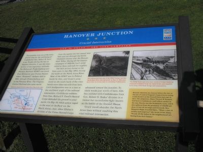
This junction was one of the most pivotal sites for the well-being of Confederate Gen. Robert E. Lee’s army. Known during the war as Hanover Junction, it was the intersection of two important railroads. The Richmond, Fredericksburg and Potomac Railroad (RF&P) ran north from Richmond, past Guinea Station where “Stonewall” Jackson died in 1863, through Fredericksburg and to the Potomac River. The Virginia Central Railroad also came north from the capital city but veered west here and ran through the fertile Piedmont country into the Shenandoah Valley. During all the famous campaigns of 1862-64, Lee’s army relied on these railroads for supplies.
The first serious threat to the lines came in late May 1864, during the battle at the North Anna River. Most of the RF&P was in Federal hands by then, and Grant’s army stood on the south bank of the river barely more than one mile from here. Lee’s headquarters was in a tent in the southwest angle of the railroad intersection. Confederate soldiers from Gen. Richard S. Ewell’s Second Corps defended the ground to your north. On May 24, while action raged to the west at Ox Ford (on
this page online
Grant would abandon the North Anna lines without reaching this vital railroad intersection.
(sidebar) Hanover Junction was famous before the war as the site of Virginia’s largest horse racing track, located on the Doswell farm just east of here. The proprietor, Major Thomas W. Doswell, had been a Confederate staff officer earlier in the war. Nearby was the DeJarnette farm, which also suffered from the proximity of 150,000 soldiers. It lost all its crops and livestock. Mrs. Margaret Wight boarded there. “What a time of anxiety and suspense,” she wrote in her diary. “Nearly all the ladies in the neighborhood are fleeing from their homes.”
(captions)
Situation along the North Anna River, May 24-26, 1864.
The still-smoldering ruins of the RF&P bridge over the North Anna River, photographed on May 25, 1864, just hours after its destruction by retreating Confederates.
The RF&P Railroad (seen here north of Fredericksburg) conveyed wounded from battlefields and supplied Lee’s army with food, forage and ammunition.
Erected by Virginia
Photographed by Bill Coughlin, April 21, 2007
2. Hanover Junction - Critical Intersection
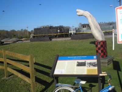
Virginia Civil War marker with railroad in the background.
Topics and series. This historical marker is listed in this topic list: War, US Civil. In addition, it is included in the Virginia Civil War Trails series list. A significant historical month for this entry is May 1864.
Location. Marker has been permanently removed. It was located near 37° 51.63′ N, 77° 27.485′ W. Marker was near Doswell, Virginia, in Hanover County. It was at the intersection of Doswell Road and Washington Highway (U.S. 1), on the left when traveling east on Doswell Road. Touch for map. Marker was at or near this postal address: 10570 Doswell Rd, Doswell VA 23047, United States of America.
We have been informed that this marker is no longer there and will not be replaced. This page is an archival view of what was.
Regionally, this marker was in the Piedmont, in Central Virginia, and in the Richmond Metropolitan Area. It was also in the American South, specifically in the Upper South, and on the Eastern Seaboard. Globally, it was in the North Atlantic Region, North America, the Western Hemisphere, the Western World, and the Anglosphere. Historically, it found itself in what was once the territory of the Mississippian Culture, one of the original Thirteen Colonies, one of the Confederate States of America, and the Antebellum South.

Other nearby markers. At least 8 other markers are within 2 miles of this location, measured as the crow flies: Lee’s Movements (approx. 1.3 miles away); North Anna River Campaign (approx. 1.4 miles away); The Eiffel Tower (approx. 1.6 miles away); The Shenandoah Lumber Company (approx. 1.6 miles away); The Scooby-Doo Ghoster Coaster (approx. 1.6 miles away); Boo Boo's Tree Swings (approx. 1.6 miles away); The Blue Ridge Tollway (approx. 1.6 miles away); Ranger Smith's Jeep Tour (approx. 1.6 miles away). Touch for a list and map of all markers in Doswell.
Another marker is no longer nearby. Hanover Junction (was approx. 0.3 miles away but has been confirmed missing).
Credits. This page was last revised on November 2, 2025. It was originally submitted on November 27, 2007, by Bill Coughlin of Woodland Park, New Jersey. This page has been viewed 4,793 times since then and 184 times this year. Last updated on November 1, 2025, by Evan Dwyer of Richmond, Virginia. Photos: 1, 2. submitted on November 27, 2007, by Bill Coughlin of Woodland Park, New Jersey. • Bernard Fisher was the editor who published this page.
