Parole in Annapolis in Anne Arundel County, Maryland — The American Northeast (Mid-Atlantic)
Trunk of the Three Mile Oak
Photographed by F. Robby, December 30, 2003
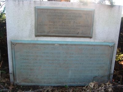
1. Trunk of the Three Mile Oak Marker
Lower Plaque: Trunk of the Three Mile Oak
Under this tree passed General George Washington December 19, 1783 on his way to Annapolis to resign his commission as Commander-in-Chief of the Continental Armies; and it is thought that General Smallwood accompanied by General Gates and distinguished citizens of Annapolis met General Washington at this spot. General Lafayette passed here December 17, 1824 to visit the friends of the revolutionary days.
Erected by Four Rivers Garden Club, Rotary Club of Annapolis.
Topics and series. This historical marker is listed in these topic lists: Colonial Era • Government & Politics • Military • Patriots & Patriotism. In addition, it is included in the Former U.S. Presidents: #01 George Washington, the Lafayette’s Farewell Tour, and the Rotary International series lists. A significant historical date for this entry is December 19, 1852.
Location. 38° 59.075′ N, 76° 32.676′ W. Marker is in Annapolis, Maryland, in Anne Arundel County. It is in Parole. It is at the intersection of West Street (Maryland Route 450) and John Hanson Highway
this page online

Regionally, this marker is in Central Maryland. It is also in the American Mid-Atlantic, in the Chesapeake Bay Region, and on the Eastern Seaboard. Globally, it is in the North Atlantic Region, North America, the Western Hemisphere, the Western World, and the Anglosphere. Historically, it finds itself in what was once one of the original Thirteen Colonies and also the Antebellum South.
Other nearby markers. At least 8 other markers are within walking distance of this marker: The General’s Highway (approx. 0.2 miles away); Camp Parole (approx. half a mile away); Political Representation in Ward Three, Parole (approx. 0.8 miles away); You Are Here (approx. 0.8 miles away); What's In A Name? (approx. 0.8 miles away); Mount Olive African Methodist Episcopal Church (approx.
Photographed by F. Robby, October 31, 2007
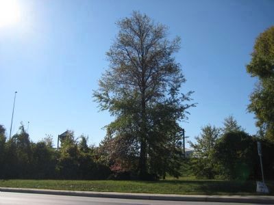
2. Oak Tree planted in 1967
This oak tree was planted directly behind the stone marker holding the two plaques, to commemorate the original Three Mile Oak.
More about this marker. The bottom brass tablet was originally located two-tenths of a mile further west on West Street at its intersection with Generals Highway (MD 178) and Defense Highway (MD 450). It was moved to its current location in 1967 to protect it from the growing road traffic. This tablet is the same one pictured in Horydczak and Besley photos below, on the concrete block beneath the trunk. The block remains at its original location. On the opposite side of the road from the site of the Three Mile Oak and original marker is a more modern historical marker erected in 1973 when the Equitable Bank and Annapolis Mall were built.
Regarding Trunk of the Three Mile Oak. The Three Mile Oak got its name because it stood three miles from the Maryland State House. Up through the early 1900s, prominent Annapolis citizens frequently met distinguished visitors at the Three Mile Oak and escorted them into town.
In 1783, Annapolis was acting as the capital of the American colonies, hosting the Continental Congress in the state house building. Having
Photographed by Theodor Horydczak, c.1950
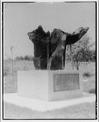
3. Library of Congress Photo
This photograph from the Library of Congress is titled "Sculpture of trunk of Three Mile Oak", but is the actual trunk, not a sculpture. After the tree finally blew over around 1900, local citizens had a concrete block built at the site of the tree and mounted the remaining pieces on it with a central shaft and supporting rods. The central shaft can just be made out in the photo. Photo credit: LOC, Prints & Photographs Division, Theodor Horydczak Collection, LC-H813-1271-012.
Additional commentary.
1. About the Three Mile Oak
"Presumably a white oak, about six feet in diameter, located three miles from Annapolis, Anne Arundel County. A delegation met George Washington here on 12/17/1783, enroute to Annapolis (then the U.S. capitol) to resign his commission. A piece of the trunk is preserved at Anne Arundel Community College. The tree was struck by lightning, became hollow, was killed by fire, and finally blew down on 5/22/1909."
From Great Eastern Trees, Past and Present, by Colby B. Rucker, February 2004 (http://www.nativetreesociety.org/ bigtree/great_eastern_trees.htm)
— Submitted October 11, 2007, by Kevin W. of Stafford, Virginia.
2.
Photographed by Fred Besley, c.1950
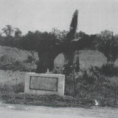
4. Trunk of the Three Mile Oak
This photo was copied from Fred Besley's 1956 version of his book "Big Tree Champions of Maryland". The photo is included in the back of the book without comment. Locals claimed it was up to 250 feet tall, certainly an exaggeration given that current White Oak champions in Maryland are around 125 feet. But this photo shows a little more of the surrounding area in the early-mid 1900s which is clearly still rural in nature, despite its proximity to the state capital. Approaching Annapolis from the West with its enormous branches hanging over the roadway, the Three Mile Oak must have made quite an impression.
Looking through old copies of The Evening Capital, Annapolis' daily newspaper, I found several articles authored by Eva Dorsey Carr Gasperich and others on the subject of the Three Mile Oak. Mrs. Gasperich fondly remembered stories she was told by her grandparents and others about the importance of the Three Mile Oak in local and national history. In the mid 1900s she was trying to help raise awareness of original Trunk of the Three Mile Oak marker and the need to protect it from encroaching business and traffic. The marker was eventually moved to a new location in 1967. Mrs. Gasperich died in 1969.
In February of 1958, her poetic, two-part series about the tree envisioned Susquehannah and Piscatawey Indians making treaties of war and peace under its branches, Annapolis' founders meeting to establish Maryland's new capital, George Washington surveying the end of a new road from Williamsburg to Annapolis, farmers and planters debating British taxes, and finally where General Washington turned down an opportunity to become King of America. A quote from the last sentence of her first-part of the series: "But I remember Dr. Elihu S. Riley [Annapolis historian] most vividly of all, removing his hat to salute that
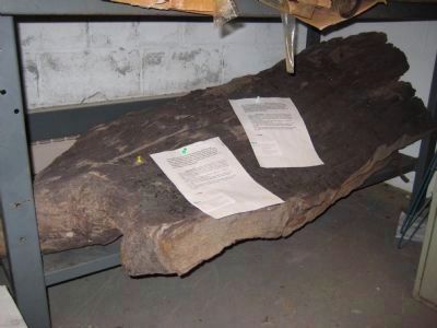
Photographed by F. Robby, November 21, 2007
5. Remains of the Trunk
The remains of the trunk (about 4-5 feet long) of the Three Mile Oak are stored in the Careers Building of the Anne Arundel Community College in Arnold, Maryland. This part of the trunk is the left portion of the trunk in the Horydczak photo. This piece was treated with a preservative when the college received it in 1988, and it has been stored ever since in a closet - it is not on display. Prior to 1988, Colby Rucker kept the trunk in his tobacco barn. The school is renovating the Careers Building in 2008 and will probably be moving the trunk to another location.
— Submitted February 23, 2008, by F. Robby of Baltimore, Maryland.
3. Herbert Hoover
Elmer M. Jackson, Jr. wrote a piece for The Evening Capital in Annapolis the day after the trunk of the Three Mile Oak was removed from its original location in November of 1967. In the article, Jackson recalled the last time the tree location was used to greet a visiting dignitary:
The oak was last used as an official meeting place during the administration of President Herbert C. Hoover. The Mayor of Annapolis, then Walter E. Quenstedt, members of the City Council and other municipal officials gathered at the oak to welcome Hoover on his visit to Annapolis for an engagement at the Naval Academy. They arrived early after making arrangements with the White House for a handshaking ceremony.
To the amazement of the Annapolis contingent, Hoover's motorcade moved pass the astonished Annapolitans while travelling at a speed estimated at 60 miles an hour. There wasn't even a wave from the nation's Chief Executive as his car whizzed by the waiting
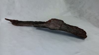
Photographed by F. Robby, August 14, 2014
6. Branch of the Three Mile Oak
This is a branch of the Three Mile Oak about 3-4 feet in length. The remains of the tree, including this branch and the trunk from the photo above, were transferred to the collection of the Maryland State Archives in Annapolis in 2012.
Quenstedt, a Republican presiding over a city council that was predominately Democratic, took quite a ribbing over the President's "slight", particularly because Hoover also represented the G.O.P.
Years later, we mentioned the incident to Hoover when he was in Florida aboard his yacht, and while along in years the former President was still able to keep three secretaries on the hop. He only smiled when we reminded him of his hurried trip from Washington to Annapolis. He was a delightful gentleman.
— Submitted February 23, 2008, by F. Robby of Baltimore, Maryland.
4. Three Mile Oak Fire Stories
Colby Rucker (Additional Comments #1) summarized the destruction of the Three Mile Oak, which was “struck by lightning, became hollow, was killed by fire, and finally blew down on 5/22/1909." I’ve been searching for historic references to the fire and the eventual toppling of the tree, but so far have only come across a few interesting
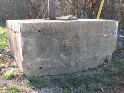
Photographed by F. Robby, December 18, 2007
7. Concrete Block
This is the concrete block, built by Frank Gilliam some time in the 1910s or 1920s, that still stands at the original site of the Three Mile Oak alongside MD 450 at its intersection with Generals Highway (MD 178). The holes on this side of the block once held the lower brass tablet titled "Trunk of the Three Mile Oak".
In 1954, Richard Manning reported in The Evening Capital that the trunk of the Three Mile Oak was severely infested with termites and needed attention. As reported in his article, a Mrs. Minnie Richardson claimed the tree burned down in the late 1890s by some raccoon hunters who were trying to smoke out their prey from its hollow trunk. Mrs. Richardson lived on the farm where the tree was located, which had been previously owned by her grandfather, who bought the property from the Howard brothers, who were owners of the estate when George Washington travelled under the tree on his way to resign his commission.
Eva Dorsey Gasperich tells in 1958 that the tree “went up in a pillar of fire one bitter, blowing winter night in early 1900.” She blamed the fire on a tramp using the hollow tree for shelter, heating his “stolen beans” and warming up his feet. All that was left the next day was a quarter of the charred trunk. It’s not clear if she was remembering the fire, the later wind, or both. The tramp story may be influenced by the fact that the area around Three Mile Oak was frequented by “hobos” and “gypsies”. In the late 1800s and early 1900s, several newspaper
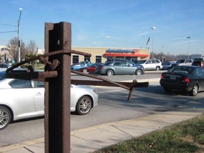
Photographed by F. Robby, December 18, 2007
8. Site of the Three Mile Oak
This photo of the intersection of MD 450 and Generals Highway shows the massive change in scenery from the Horydczak or Besley photos. The rusty post and rods in the foreground that used to support the trunk still stick out from the top of the concrete block. Beyond the passing traffic is the Bank of America (former location of the Equitable Bank) where a newer Three Mile Oak marker is located. This area of Annapolis used to be referred to as "3 Mile Oak", but is now simply known as the home of the Annapolis Mall.
In 2007 while looking for the remains of the trunk at Anne Arundel Community College, I spoke with Dr. Hal Counihan, a history professor at the college. Dr. Counihan was present in 1988 when the college took possession of the trunk from the same Colby Rucker above, and reported that Mr. Rucker had kept the trunk in his tobacco barn since its removal from the concrete block in 1967. Dr. Counihan spoke of the careless hunters and gypsies, but he also had another interesting fire story. It seems that some folks at the time of the fire believed the tree may have been deliberately burned by Johnnies – students of St. John’s College in Annapolis – as a college prank and/or jealousy over competing historic attention with the Three Mile Oak. St. John’s College was home of another famous historic Annapolis tree: the Liberty Tree, the last of the so-called trees where the Sons of Liberty met to hear revolutionary-patriots speak. The Liberty Tree, a tulip-poplar, was taken down in 1999 after fatal damage from Hurricane Floyd and has been
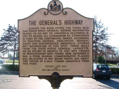
Photographed by F. Robby, December 30, 2003
9. The General's Highway Marker
This marker located across the street from the original site of the Trunk of the Three Mile Oak marker, two-tenths of a mile further west as stated on the new marker.
— Submitted February 24, 2008, by F. Robby of Baltimore, Maryland.
5. Remembering three mile oak stump
I remember seeing an old hollow stump on the concrete block in the 1974 to 1979 time. I used to work near the site of the new bowling alley in building that burned down in December of 1979. I would get lunch from the liquor/deli store across from the stump.
— Submitted July 1, 2015, by Aubrey Francis Patterson of Annapolis, Maryland.
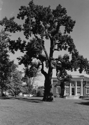
undated
10. Liberty Tree
The Liberty Tree on the campus of St. John's College is another historic Annapolis tree from the time of the Revolution. See Additional Comments #4 above for a tie-in with the Three Mile Oak. The Liberty Tree was taken down in 1999 after damage from heavy winds. Photo credit: www.stjohnscollege.edu.
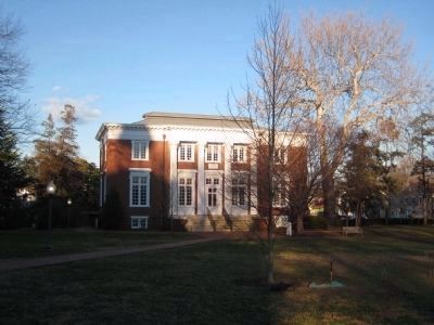
Photographed by F. Robby, January 28, 2008
11. New Liberty Tree
This tree was planted in 2007 on the site of the original Liberty Tree where another historical marker speaks of the Liberty Tree.
Credits. This page was last revised on September 9, 2023. It was originally submitted on October 9, 2007, by F. Robby of Baltimore, Maryland. This page has been viewed 7,728 times since then and 314 times this year. Photos: 1. submitted on October 9, 2007, by F. Robby of Baltimore, Maryland. 2, 3. submitted on November 30, 2007, by F. Robby of Baltimore, Maryland. 4. submitted on February 23, 2008, by F. Robby of Baltimore, Maryland. 5. submitted on November 30, 2007, by F. Robby of Baltimore, Maryland. 6. submitted on September 1, 2014, by F. Robby of Baltimore, Maryland. 7, 8. submitted on February 23, 2008, by F. Robby of Baltimore, Maryland. 9. submitted on October 9, 2007, by F. Robby of Baltimore, Maryland. 10, 11. submitted on February 24, 2008, by F. Robby of Baltimore, Maryland. • J. J. Prats was the editor who published this page.
Editor’s want-list for this marker. Period photo of the tree, and of the intersection where it stood. • Can you help?
