Saqarah in Badrshein, Giza Governorate, Egypt — مصر (Northeast Africa)
The Southern Tomb

Photographed by James Hulse, October 8, 2024
1. The Southern Tomb Marker
 The Southern tomb is located at the southwestern corner of the King Djoser funeral complex dating to the 3rd Dynasty, Old Kingdom period. This magnificent complex is the oldest stone building of the ancient world. It was discovered by the English archaeologist Cecil Malaby Firth in 1928.
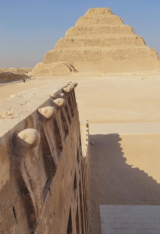
Significantly, the tomb is composed of an upper level in the form of a rectangular stone building. Its walls are decorated with a series of stone sockets in the form of entrances and exits, crowned by a frieze of cobra heads, the lower level of the tomb represents an entrance towards a ramp leading to the burial chamber, which is located at the bottom of a great shaft measuring 7.5 x 7.5 m, and with a depth of approximately 31m, including a huge sarcophagus made of 16 blocks of pink granite, measuring approximately 3.6 m high. Furthermore, one can note the similarity between the well and the sarcophagus with those inside the step pyramid.
One of the most important architectural and decorative elements of the Southern Tomb are a series of corridors, one of which contains three false doors, each topped with exquisite reliefs depicting the king taking part in the Heb-Sed Festival. This was a vital event, a royal jubilee, with the aim to rejuvenate the king and renew his right to rule. Several walls of the southern tomb's corridors are decorated with the same blue faience tiles into the step pyramid. The French architect Jean-Philippe Lauer believed that this Southern Tomb was a symbolic burial for the king's soul, replacing the royal tomb at Abydos (in Sohag governorate).
The tomb at time of discovery in 1928
Illustration of Heb-Sed Festival inscription
Perspective of the tomb
Tombeau Sud
Le tombeau est situé à l'angle sud-ouest du complexe funéraire du roi Djéser (Illème dynastie de l'Ancien Empire), le plus ancien monument en pierre à grande échelle encore debout dans le monde antique. Il a été découvert par l'archéologue anglais Cecil Malaby Firth en 1928. Il se compose d'une partie supérieure sous la forme d'un bâtiment en pierre rectangulaire, ses murs sont décorés d'un groupe de corniches surmontées d'une frise de cobras. Concernant la partie inférieure du tombeau, elle comporte une entrée menant à une rampe qui donne accès à la chambre funéraire, située au fond d'un immense puits mesurant environ 7.5 x 7.5 m et 31 m de profondeur; s'y trouve un immense caveau en graníte rose constitué de 16 blocs, mesurant 3.6 m de hauteur. De plus, on peut noter une similitude entre le puits et le caveau avec ceux à l'intérieur de la pyramide à degrés.
L'un des éléments architecturaux et décoratifs les plus importants du tombeau sud est un groupe de couloirs, dont l'un présente 3 portes factices ayant au milieu, des reliefs représentant le roi lors de la fête de Heb Sed, jubilé
this page online
L'architecte français Philippe Lauer croyait qu'il s'agissait d'un enterrement symbolique pour l'âme du roi remplaçant le tombeau royal à Abydos (dans le gouvernorat de Sohag)
Tombeau sud au temps de découverte
Illustration montrant la fête du Heb Sed
Perspective du tombeau
المقبرة الجنوبية
المقبرة الجنوبية في الركن الجنوبي الغربي من مجموعة الملك زوسر الجنائزية التي تعد أقدم بناء حجري في العالم القديم (الدولة القديمة - الأسرة الثالثة، والتي اكتشفها الأثري الإنجليزي سيسيل مالابي فيرث" عام ١٩٢٨م.
تتكون المقبرة من جزء علوي على هيئة بناء حجري مستطيل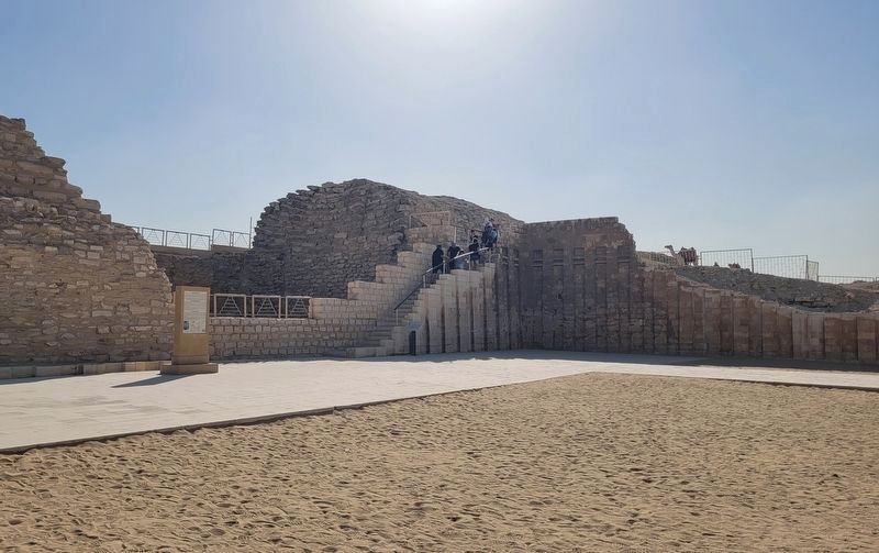 الشكل، وتزين جدرانه مجموعة من الأكتاف الحجرية على هيئة الدخلات والخرجات التي يعلوها افريز مزين بحيات الكوبرا. أما عن الجزء السفلي من المقبرة فهو يتكون من مدخل يؤدي إلى ممر منحدر ينتهي بحجرة للدفن والتي تقع في قاع بئر ضخم مربع الشكل يبلغ طول ضلعه حوالي ٧.٥ م وعمقه ٣١ م تقريبا، وتحتوي غرفة الدفن على تابوت ضخم مكون من ١٦ كتلة من الجرانيت الوردي الذي يبلغ ارتفاعه ٣.٦ م. كما
 يمكن ملاحظة التشابه الكبير بين هذا البئر والتابوت مع تلك الموجودة أسفل الهرم المدرج.
ولعل من أهم العناصر المعمارية والزخرفية المميزة للمقبرة الجنوبية وجود عدد من الممرات السفلية التي يحتوي إحداها على ثلاثة أبواب وهمية يحمل كل منها نقش للملك زوسر في احتفال "حب سد"، وهو اليوبيل الملكي الذي كان يحتفل فيه بجلوس الملك على العرش تغطى جدران الممرات مجموعة من بلاطات الفيانس (القيشاني) الأزرق مماثلة لتلك التي تغطى الممرات السفلية تحت الهرم المدرج. يرى المعماري الفرنسي "جان فيليب لوير " أنها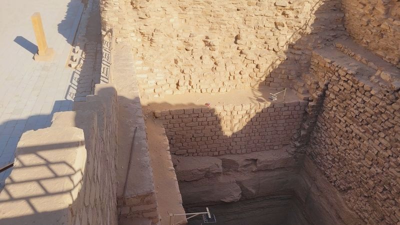 كانت تمثل مقبرة رمزية للملك تعادل المغيرة الملكية في أبيدوس (بمحافظة سوهاج).
المقبرة الجنوبية وقت اكتشافها عام ١٩٢٨
رسم توضيحى لنقش احتفال حب سد
رسم منظوري يوضح تخطيط المقبرة
المقبرة الجنوبية في الركن الجنوبي الغربي من مجموعة الملك زوسر الجنائزية التي تعد أقدم بناء حجري في العالم القديم (الدولة القديمة - الأسرة الثالثة، والتي اكتشفها الأثري الإنجليزي سيسيل مالابي فيرث" عام ١٩٢٨م.
تتكون المقبرة من جزء علوي على هيئة بناء حجري مستطيل
Photographed by James Hulse, October 8, 2024
2. The Southern Tomb and Marker
The shaft down to the tomb is behind the metal fence along the wall.
Photographed by James Hulse, October 8, 2024
3. The Cobra Wall from the tomb and the Step Pyramid
ولعل من أهم العناصر المعمارية والزخرفية المميزة للمقبرة الجنوبية وجود عدد من الممرات السفلية التي يحتوي إحداها على ثلاثة أبواب وهمية يحمل كل منها نقش للملك زوسر في احتفال "حب سد"، وهو اليوبيل الملكي الذي كان يحتفل فيه بجلوس الملك على العرش تغطى جدران الممرات مجموعة من بلاطات الفيانس (القيشاني) الأزرق مماثلة لتلك التي تغطى الممرات السفلية تحت الهرم المدرج. يرى المعماري الفرنسي "جان فيليب لوير " أنها
Photographed by James Hulse, October 8, 2024
4. The view looking down the shaft of the Southern Tomb
المقبرة الجنوبية وقت اكتشافها عام ١٩٢٨
رسم توضيحى لنقش احتفال حب سد
رسم منظوري يوضح تخطيط المقبرة
Erected by UNESCO World Heritage.
Topics. This historical marker is listed in this topic list: Anthropology & Archaeology. A significant historical year for this entry is 1928.
Location. 29° 52.148′ N, 31° 12.993′ E. Marker is in Saqarah, Giza Governorate, in Badrshein. It is on Pyramid of Djoser Road. Touch for map. Marker is at or near this postal address: Pyramid of Djoser Rd, Saqarah, Giza Governorate 33520-01, Egypt. Touch for directions.

Regionally, it is in Africa, specifically in North Africa, in the Middle East, on the Red Sea, and in a coastal Mediterranean country. Historically, it finds itself in what was once the Byzantine Empire, the Ottoman Empire, a British colony, and the Roman Empire.
Other nearby markers. At least 8 other markers are within walking distance of this marker: The Step Pyramid / الهرم المدرج (a few steps from this marker); South Court (within shouting distance of this marker); Colonnade Entrance (about 120 meters away, measured in a direct line); Enclosure Wall (about 120 meters away); Step Pyramid Complex (about 150 meters away); South Entrance of The Step Pyramid (about 150 meters away); The Tomb of Mereruka (approx. 0.8 kilometers away); The Funerary Complex of King Teti (approx. 0.9 kilometers away). Touch for a list and map of all markers in Saqarah.
Also see . . . Pyramid of Djoser. Wikipedia
South tomb - Relief of Djoser facing the temple of Horus of Behedet (modern Edfu) in a blue faience chamber of the south tomb. The south tomb has been likened to the satellite pyramids of later dynasties, and has been proposed to house the ka in the afterlife. Another proposal is that it may have held the canopic jar with the king's organs, but this does not follow later trends where the canopic jar is found in the same place as the body. These proposals stem from the fact that the granite burial vault is much too small to have facilitated an actual burial.(Submitted on November 6, 2025, by James Hulse of Medina, Texas.)
Credits. This page was last revised on November 6, 2025. It was originally submitted on November 5, 2025, by James Hulse of Medina, Texas. This page has been viewed 86 times since then and 43 times this year. Photos: 1, 2, 3, 4. submitted on November 6, 2025, by James Hulse of Medina, Texas.
