Lincoln in Lancaster County, Nebraska — The American Midwest (Upper Plains)
Neighborhood History
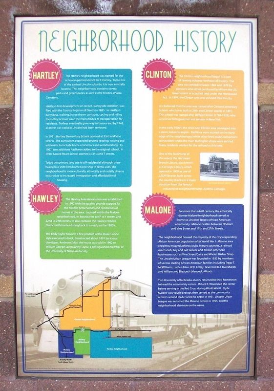
Photographed by William Fischer, Jr., February 12, 2012
1. Neighborhood History Marker
Hartley
The Hartley neighborhood was named for the school superintendent Ellis T. Hartley. Once one of the earliest Lincoln suburbs, it is now centrally located. This neighborhood contains several parks and greenspaces, as well as the historic Wyuka Cemetery.
Hartley's first development on record, Sunnyside Addition, was filed with the County Register of Deeds in 1885. In Hartley's early days, walking, horse drawn carriages, cycling and riding the trolley or train were the main modes of transportation for residents. Trolleys eventually gave way to busses and by 1948, all street-car tracks in Lincoln had been removed.
In 1921, Hartley Elementary School opened at 33rd and Vine streets. The curriculum expanded beyond reading, writing and arithmetic to include home economics and woodworking. By 1967, two additions had been added to the original school. In 1928, Sacred Heart School opened at 31st and T streets.
Today the primary land use is still residential although there has been a shift from homeownership to rental uses. The neighborhood is more culturally, ethnically and racially diverse in part due to increased
this page online
Hawley
The Hawley Area Association was established in 1997 with the goal to provide support for the historic preservation and restoration of homes in the area. Located within the Malone neighborhood, its boundaries are P to Y streets and 22nd to 27th streets. It also contains the Hawley Historic District with homes dating back to as early as the 1880's.
The Eddy-Taylor house is a fine product of the Queen Anne style executed in brick. Constructed about 1891 by a local developer, Ambrose Eddy, the house was sold in 1902 to William George Langworthy Taylor, a distinguished member of the University of Nebraska faculty.
Clinton
The Clinton neighborhood began as a sort of farming outpost northeast of the city. The area was settled between 1864 and 1879 by pioneers who either purchased land from the U.S. Government or acquired land under the Homestead Act. In 1897, the Clinton area was annexed into the city.
It is believed that the area was named after Clinton Elementary School, which was built at 29th and Clinton streets in 1891. The school was named after DeWitt Clinton (1769-1828),

Photographed by William Fischer, Jr., February 12, 2012
2. Neighborhood History Marker
In the early 1900's, the once rural Clinton area developed into a more industrial region. Rail lines were located on the north edge of the neighborhood while other lines made connections to Havelock where the main Burlington shops were located. Many residents worked for the railroad at this time.
One of the landmarks of this area is the Northeast Branch Library, which opened in 1909 as one of 2,509 libraries built across the country thanks to a major donation from the famous industrialist and philanthropist, Andrew Carnegie.
Malone
For more than a half century, the ethnically diverse Malone Neighborhood served as home to Lincoln's largest African American community. Malone nestles between O Street and Vine Street and 17th and 27th Streets.
The neighborhood housed the majority of the city's expanding African American population after World War I. Malone area residents enjoyed athletic clubs, literary societies, a railroad men's club, Boy and Girl Scouts, and African American businesses such as Vine Street Dairy and Wade's Barber Shop. The Lincoln Urban League was founded in 1933 by members of several leading African American families including Trago T. McWilliams, Luther Allen, W.R. Colley, Reverend O.J. Burckhardt, and William and Elizabeth (Hancock) Woods.
Two University of Nebraska alumni returned to their hometown to head the community center. Millard T. Woods led the center before serving in the Red Cross during World War II. Clyde Malone was youth director, then served as the community center's second leader until his death in 1951. Lincoln Urban League was renamed the Malone Center in 1955, and the neighborhood also took on the name.
[Captions:]
Background photo: Missouri Pacific 7001, "the Route of the Eagles" diesel passenger service at Jefferson City, Missouri on June 6, 1948.
Erected by Nebraska Dept of Roads, Great Plains Trails Network, Lincoln Cares, and Concerned Citizens and Organizations.
Topics. This historical marker is listed in these topic lists: African Americans • Immigration • Industry & Commerce • Settlements & Settlers. A significant historical year for this entry is 1885.
Location. 40° 49.409′ N, 96° 40.926′ W. Marker is in Lincoln, Nebraska, in Lancaster County. It is on 27th Street north of W Street, on the left when traveling north. Marker is on the SE pier of the MoPac Trail's Elaine Hammer Bridge. Touch for map. Marker is in this post office area: Lincoln NE 68503, United States of America. Touch for directions.

Regionally, this marker is in the American Midwest, in the Corn Belt, and on the prairies. Globally, it is in North America, the Western Hemisphere, the Western World, and the Anglosphere. Historically, it finds itself in what was once the Louisiana Purchase.
Other nearby markers. At least 8 other markers are within one mile of this marker, measured as the crow flies: Missouri Pacific History (here, next to this marker); Elaine Hammer Bridge (within shouting distance of this marker); Paul A. "Doc" Downs (approx. 0.9 miles away); Institute of Agriculture and Natural Resources (approx. 0.9 miles away); The Lewis-Syford House (approx. 0.9 miles away); RHO Chapter House (approx. 0.9 miles away); Pershing Rifles (approx. one mile away); The Nebraska State Historical Society (approx. one mile away). Touch for a list and map of all markers in Lincoln.
Credits. This page was last revised on March 5, 2026. It was originally submitted on November 6, 2025, by William Fischer, Jr. of Reynoldsburg, Ohio. This page has been viewed 119 times since then and 85 times this year. Photos: 1, 2. submitted on November 6, 2025, by William Fischer, Jr. of Reynoldsburg, Ohio.
