Luxor, Luxor Governorate, Egypt — مصر (Northeast Africa)
Sacred Lake
⎯⎯⎯
Lac sacré
البحيرة المقدسة
Photographed by James Hulse, October 10, 2024
1. Sacred Lake / Lac sacré Marker
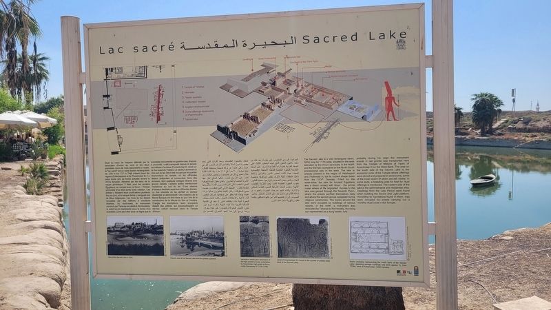
 The Sacred Lake is a vast rectangular basin, 200m long by 117m wide, situated in the area delimited by the Amun sanctuary in the North and the first two courtyards on the North-South processional axis in the west. The lake is already present in the reigns of Hatshepsut and Thutmosis III, but its current shape dates from the XXVth Dynasty. Filled by the water-table, the lake for Ancient Egyptians was a direct contact with Noun - the primal ocean where all life originated. Access to the lake was gained through the Seventh Pylon, where the priests purified themselves daily and where the sacred barque navigated during religious ceremonies. The banks around the lake were occupied by buildings of various natures. In the north, a monument was dedicated by Taharqa to Ra-Horakty, the rising sun represented as a dung beetle. And probably during his reign the monument scarab in red granite was transported here from the Temple of Millions of Years of Amenhotep III on the West Bank. The area on the south side of the Sacred Lake is the economic zone of the Temple where offerings were stored and prepared in storerooms, some of
this page online
Captions
(Photo #1) View of the Sacred Lake in 1870. © CFEETK, Chevrier 11, 1926-54
(Photo #2) Recent view of the Sacred Lake from the priests' quarters. © CFEETK, Huguenin D., 2001
(Photo #3) Inscription relating the restoration of the high-priests's house undertaken by Amenhotep, high-priest of Amun, under Ramesses IX (1125-1108). © CFEETK, Legrain G., 1895-1917
(Photo #4) Lintel of Ameneminet, II's house in the quarter of priests (east bank of the Sacred Lake). © CFEETK, Bellod A., 1970
(Photo #5) Scene probably representing the south bank of the Sacred Lake, depicting storage buildings and birds (geese ?), from TT284, tomb of Pahemneter, XIXth Dynasty. © Barguet P., in Le temple d'Amon-Re à Karnak, RAPH 21, Le Caire
Situé
Photographed by James Hulse, October 10, 2024
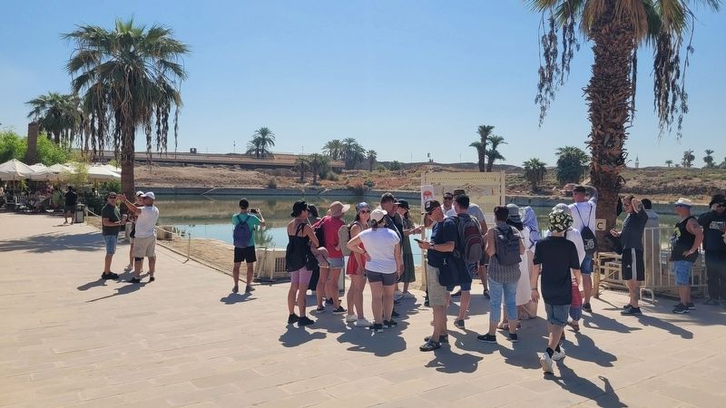
2. The view of the Sacred Lake and Marker
البحيرة المقدسة
جرانيت الوردي المنتصب على مقربة، بعد نقله من سعيد ملايين السنين الذي شيده أمنحتب الثالث على الضفة الغربية لطيبة أما القطاع المشرف على الضفة الجنوبية للبحيرة المقدسة فتشغله الأنشطة الإقتصادية المعبد، حيث كانت تُحَضّر النذور والقرابين وتُحفظ داخل ملحقات أبنية لاتزال بعض شواهدها شاخصة للعيان. وتشير بعض النصوص إلى وجود محمية للطيور جنوب البحيرة المقدسة كانت أيضاً مُكرَّسة للتقدمات الإلهية. وتضم الضفة الشرقية للبحيرة قطاعاً للسكنى والإدارة. وأثناء تشييد مدرجات الصوت والضوء، تم إماطة اللثام عن منازل تعود إلى العصر المتأخر. وتشير النصوص إلى أن قاطنيها كانوا من الكهنة المكلفين بإقامة طقوس شهرية داخل معبد آمون تشغل البحيرة المقدسة وسط الفراغ الذي تحده مقصورة آمون شمالاً والفناءان الأولان للمحور الفرعي غرباً. وهي عبارة عن بركة فسيحة، مستطيلة الشكل، تبلغ أبعادها ۲۰۰ متراً في ١١٧ متراً. وقد كانت قائمة خلال عصري كل من حتشبسوت وتحتمس الثالث، وإن كانت على الأرجح إتخذت شكلها الحالي إبان عهد الأسرة الخامسة والعشرين. وتغذي حقول المياه الجوفية البحيرة المقدسة التي كان المصريون القدماء يعتبرونها متصلة بالنون المحيط الأزلي الذي انبثقت من خضمه جميع المخلوقات. وكان الكهنة يتطهرون بمائها مرات عديدة يومياً، كما يطفو على صفحتها المركب المقدس أثناء الأعياد والاحتفالات الدينية. وكانت تشغل ضفاف البحيرة أبنية ذات وظائف شتّى. إذ نجد في الناحية الشمالية الغربية بناءً شيده طهرقا وكرسه لرع حور أختي الشمس المشرقة والمُصَوَّرة على هيئة جعران. وربما يرجع إلى هذا العهد الجعران الضخم من
جرانيت الوردي المنتصب على مقربة، بعد نقله من سعيد ملايين السنين الذي شيده أمنحتب الثالث على الضفة الغربية لطيبة أما القطاع المشرف على الضفة الجنوبية للبحيرة المقدسة فتشغله الأنشطة الإقتصادية المعبد، حيث كانت تُحَضّر النذور والقرابين وتُحفظ داخل ملحقات أبنية لاتزال بعض شواهدها شاخصة للعيان. وتشير بعض النصوص إلى وجود محمية للطيور جنوب البحيرة المقدسة كانت أيضاً مُكرَّسة للتقدمات الإلهية. وتضم الضفة الشرقية للبحيرة قطاعاً للسكنى والإدارة. وأثناء تشييد مدرجات الصوت والضوء، تم إماطة اللثام عن منازل تعود إلى العصر المتأخر. وتشير النصوص إلى أن قاطنيها كانوا من الكهنة المكلفين بإقامة طقوس شهرية داخل معبد آمون تشغل البحيرة المقدسة وسط الفراغ الذي تحده مقصورة آمون شمالاً والفناءان الأولان للمحور الفرعي غرباً. وهي عبارة عن بركة فسيحة، مستطيلة الشكل، تبلغ أبعادها ۲۰۰ متراً في ١١٧ متراً. وقد كانت قائمة خلال عصري كل من حتشبسوت وتحتمس الثالث، وإن كانت على الأرجح إتخذت شكلها الحالي إبان عهد الأسرة الخامسة والعشرين. وتغذي حقول المياه الجوفية البحيرة المقدسة التي كان المصريون القدماء يعتبرونها متصلة بالنون المحيط الأزلي الذي انبثقت من خضمه جميع المخلوقات. وكان الكهنة يتطهرون بمائها مرات عديدة يومياً، كما يطفو على صفحتها المركب المقدس أثناء الأعياد والاحتفالات الدينية. وكانت تشغل ضفاف البحيرة أبنية ذات وظائف شتّى. إذ نجد في الناحية الشمالية الغربية بناءً شيده طهرقا وكرسه لرع حور أختي الشمس المشرقة والمُصَوَّرة على هيئة جعران. وربما يرجع إلى هذا العهد الجعران الضخم من
Erected by Ministry of Tourism and Antiquities.
Topics. This historical marker is listed in these topic lists: Anthropology & Archaeology • Religion & Religious Structures. A significant historical year for this entry is 2005.
Location. 25° 43.049′ N, 32° 39.499′ E. Marker is in Luxor, Luxor Governorate. It is on El-Shaikh Mousa just east of Fondok Al Nile Helton. The marker is located on the grounds of the Karnak archaeological site. Touch for map. Marker is at or near this postal address: El-Shaikh Mousa, Luxor, Luxor Governorate 13630-67, Egypt. Touch for directions.

Regionally, it is in Africa, specifically in North Africa, in the Middle East, on the Red Sea, and in a coastal Mediterranean country. Historically, it finds itself in what was once the Byzantine Empire, the Ottoman Empire, a British colony, and the Roman Empire.
Other nearby markers. At least 8 other markers are within 3 kilometers of this marker, measured as the crow flies: Cachette courtyard / Cour de la cachette (within shouting distance of this marker); Wadjyt / Ouadjyt (about 90 meters away, measured in a direct line); Courtyard of the Third Pylon / Cour du IIIᵉᵐᵉ Pylône (about 120 meters away); The Two Obelisques Of Queen Hatshepsut (about 120 meters away); Hypostyle Hall / Salle Hypostyle (about 150 meters away); Great Forecourt / Grande Cour (about 240 meters away); Temple of Khonsu / معبد خونسو (approx. 0.3 kilometers away); Ancient Luxor / مدينة الاقصر (approx. 2.6 kilometers away). Touch for a list and map of all markers in Luxor.
Credits. This page was last revised on November 13, 2025. It was originally submitted on November 7, 2025, by James Hulse of Medina, Texas. This page has been viewed 75 times since then and 42 times this year. Photos: 1, 2. submitted on November 13, 2025, by James Hulse of Medina, Texas.
