Near Spotsylvania Courthouse in Spotsylvania County, Virginia — The American South (Mid-Atlantic)
Jackson Attacks
The Battle of Chancellorsville
| — | Fredericksburg and Spotsylvania National Military Park | — |
Photographed by Craig Swain, November 10, 2007
1. Jackson Attacks Marker
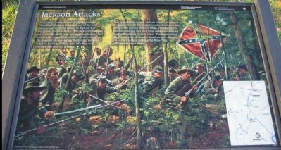
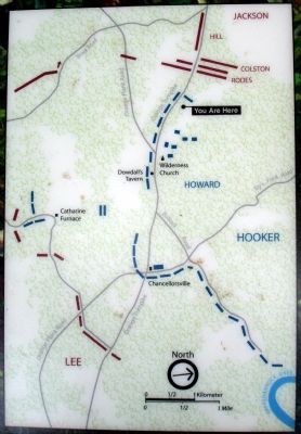
"You can go forward then." With those words "Stonewall" Jackson unleashed one of the most famous and successful attacks of the Civil War. On the afternoon of May 2, 1862, Jackson led 30,000 men of his Second Corps to a point just beyond the Union army's right flank, located in this vicinity. He deployed his men astride the Orange Turnpike (modern Route 3) in three lines of battle, each one-half mile or more in length.
Two hours before sunset, Jackson struck. As his men struggled through the tangled woods, they drove deer, rabbits, and turkeys ahead of them. The frightened animals bounded into the Union camps, causing the Northern soldiers to cheer. Their merriment quickly turned to fear as the Confederates stormed out of the woods screaming the Rebel Yell. Jackson was upon them!
Erected by National Park Service, U.S. Department of the Interior.
Topics. This historical marker is listed in this topic list: War, US Civil. A significant historical date for this entry is May 2, 1862.
Location. 38° 18.931′ N, 77° 40.879′ W. Marker is near Spotsylvania Courthouse, Virginia, in Spotsylvania County. It can be reached from Plank Road
this page online

Regionally, this marker is in the Washington Metropolitan Area, in Northern Virginia, and in the Piedmont. It is also in the American South, specifically in the Upper South, in the Mid-Atlantic, and on the Eastern Seaboard. Globally, it is in the North Atlantic Region, North America, the Western Hemisphere, the Western World, and the Anglosphere. Historically, it finds itself in what was once the territory of the Mississippian Culture, one of the original Thirteen Colonies, one of the Confederate States of America, and the Antebellum South.
Other nearby markers. At least 8 other markers are within 2 miles of this marker, measured as the crow flies: Recipe for Union Disaster (a few steps from this marker); Pressing the Attack (a few steps from this marker); The Attack Gains Momentum (approx. 0.4 miles away); 154th New York State Volunteer Infantry
September 22, 2007
2. Close-up of Map on Marker
Another marker is no longer nearby. The Flying Dutchmen (was a few steps from this marker but has been replaced with another marker now near it).
More about this marker. A Don Troiani painting sets the background of this marker. On the lower right is a map showing the arrangement of forces for the attack.
Regarding Jackson Attacks. This is one of several markers for the Battle of Chancellorsville along the Jackson's Flank March and Attack trail. See the Jackson's Flank March and Attack Virtual Tour by Markers in the links section for a listing of related markers on the tour.
Also see . . .
1. Battle of Chancellorsville. National Park Service website entry (Submitted on December 2, 2007, by Craig Swain of Leesburg, Virginia.)
2. Jackson's Flank March and Attack Virtual Tour by Markers.
Photographed by Craig Swain
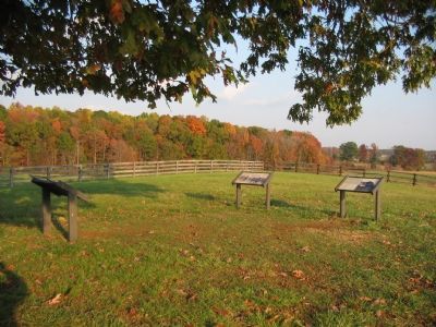
3. Three Markers at the Jackson's Flank Attack Tour Stop
Photographed by Craig Swain, February 16, 2008
4. Confederate Staging Area
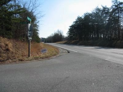
Roughly a half mile west of the marker location, looking east down the Orange Turnpike (toward the Federal positions). Jackson massed his troops here before launching the attack on the exposed Federal flanks. This location, where CR 640 intersects the highway, is within a small tract of National Park land.
Photographed by Brandon Fletcher, July 18, 2008
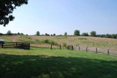
5. Jackson Attacks Marker
Just to the right of the marker, looking in the direction in which Jackson's men attacked from.
Credits. This page was last revised on November 11, 2025. It was originally submitted on December 2, 2007, by Craig Swain of Leesburg, Virginia. This page has been viewed 2,313 times since then and 45 times this year. Last updated on November 11, 2025, by Mike McKeown of Baltimore, Maryland. Photos: 1. submitted on December 2, 2007, by Craig Swain of Leesburg, Virginia. 2. submitted on January 15, 2008. 3. submitted on December 2, 2007, by Craig Swain of Leesburg, Virginia. 4. submitted on February 17, 2008, by Craig Swain of Leesburg, Virginia. 5. submitted on July 25, 2015, by Brandon Fletcher of Chattanooga, Tennessee. • Bernard Fisher was the editor who published this page.
