Near Oatman in Mohave County, Arizona — The American Mountains (Southwest)
Roads for Adventure
Photographed by Duane and Tracy Marsteller, September 30, 2025
1. Roads for Adventure Marker
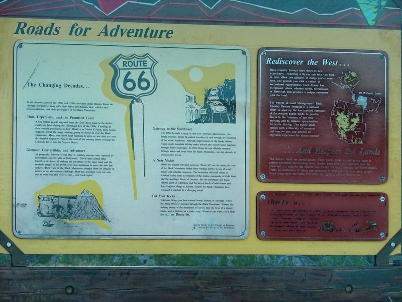
The Changing Decades
In the decades between the 1930s and 1950s, travellers along Historic Route 66 changed markedly … along with their hopes and dreams, their vehicles and accommodations, and their perspective of the Black Mountains.
Dust, Depression, and the Promised Land
A half-million people migrated from the Dust Bowl states to the fertile California fields during the Depression Era of the 1930s. Carrying all their worldly possessions in their Model A or Model T Fords, these hearty migrants feared the steep, winding grades of Route 66 over the Black Mountains. Many even hired local residents to drive or tow their car over the dreaded Sitgreaves Pass in the cool of the evening before crossing the Colorado River into the Mojave Desert.
Glamour, Convertibles, and Adventure
As prosperity followed World War Il, military convoys were replaced by convertibles and the glitz of Hollywood. Movie stars joined other travellers on Route 66 seeking the adventure of the open road, and the roadside camps of the 1930's grew into businesses to serve the new fun-seekers. Their view of the Black Mountains changed from an obstacle
this page online
Gateway to the Southwest
The 1950s brought a surge in that new American phenomenon – the family vacation. Route 66 enticed travellers to and through the heartland of the scenic Southwest. Although improvements in the family station wagon made mountain driving easier, drivers also wanted faster roadways through flatter landscapes. In 1953, Route 66 was officially rerouted through Yucca and away from the Black Mountains – one less obstacle to cross-country travel.
A New Vision
While the popular television program “Route 66” ran its course, the view of the Black Mountains shifted from winding barrier to one of scenic beauty and valuable resources. The mountains still hold visions of America's past, such as remnants of the mining community of Gold Road and the nostalgic flavor of Oatman. But the mountains also house 150,000 acres of wilderness and the largest herds of wild burros and desert bighorn sheep in Arizona. Clearly the Black Mountains have remained a constant in a changing world.
Get Your Kicks …
Whatever
Photographed by Duane and Tracy Marsteller, September 30, 2025
2. Roads for Adventure Marker
Rediscover the West …
Back Country Byways open doors to new experiences. Following a Byway can take you back in time, allow you glimpses of things you've never seen, and provide you with a variety of recreational opportunities. Each Byway has exceptional values, whether scenic, recreational, or historical, and provides a unique encounter with the land.
The Bureau of Land Management's Back Country Byways Program is a national effort to open up the less traveled corridors of the western public lands, to provide access to the treasures of our rich heritage, and to enhance opportunities for scenic driving. The public lands exhibit such a diversity of resources and uses – they can provide an enjoyable experience for almost anyone!
… And Respect the Lands
The western lands are special places. These public lands, as well as the lands in private ownership surrounding them, require grant care. The resources must be preserved, not only for the wildlife that inhabit the lands, but also for future visitors. Please be considerate of others you encounter in your journey, leave gates as you found them, pack out trash, and value the rights of private landowners/
Topics and series. This historical marker is listed in this topic list: Roads & Vehicles. In addition, it is included in the U.S. Route 66 series list. A significant historical year for this entry is 1953.
Location. 35° 1.561′ N, 114° 18.003′ W. Marker is near Oatman, Arizona, in Mohave County. It is on Oatman Highway (County Road 10) 9 miles east of Oatman, on the right when traveling west. Touch for map. Marker is in this post office area: Golden Valley AZ 86413, United States of America. Touch for directions.

Regionally, this marker is in the Colorado River Valley. It is also in the American Southwest. Globally, it is in North America, the Western Hemisphere, the Western World, and the Anglosphere. Historically, it finds itself in what was once New Spain and also Mexico’s Alta California.
Other nearby markers. At least 8 other markers are within 5 miles of this marker, measured as the crow flies: Cool Springs Station (approx. half a mile away); Gold Road Mine (approx. 4.6 miles away); Oatman Drug and Health Club (approx. 4.7 miles away); Arizona Hotel (approx. 4.7 miles away); Oatman (approx. 4.7 miles away); Gold Mining Ghost Town, Oatman, Arizona (approx. 4.7 miles away); Oatman Arizona and its Burros (approx. 4.7 miles away); a different marker also named Oatman (approx. 4.7 miles away). Touch for a list and map of all markers in Oatman.
Credits. This page was last revised on November 17, 2025. It was originally submitted on November 14, 2025, by Duane and Tracy Marsteller of Murfreesboro, Tennessee. This page has been viewed 74 times since then and 39 times this year. Photos: 1, 2. submitted on November 14, 2025, by Duane and Tracy Marsteller of Murfreesboro, Tennessee.
