Old Fort in Polk County, Tennessee — The American South (East South Central)
Marr’s Fort

Photographed by Tim Fillmon, October 27, 2025
1. Marr’s Fort Marker
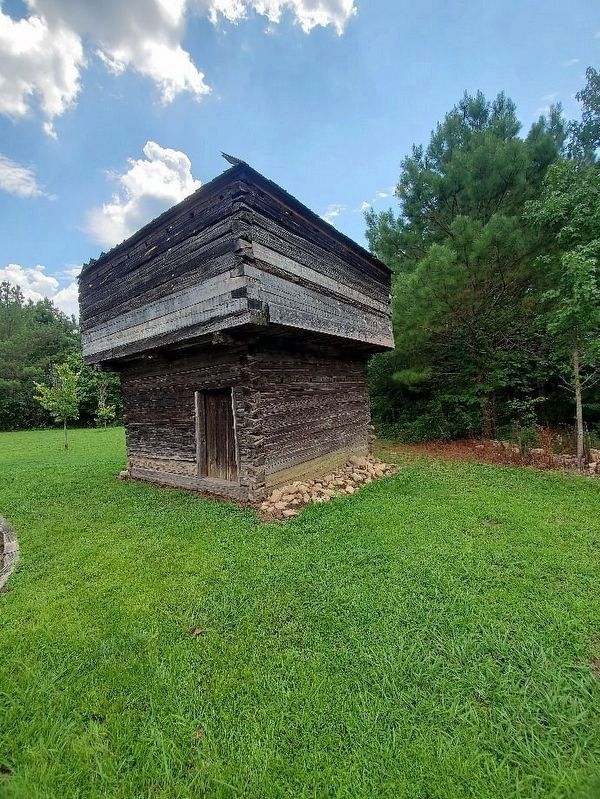
This fort was built 0.4 miles south in 1837, to facilitate assemblage of the Cherokee Nation for its enforced removal westward. A blockhouse, one of its corner bastions, survives. It was removed in 1932 and re-erected in the yard of the high school at Benton, about 10 miles north.
Erected by Tennessee Historical Commission. (Marker Number 2A 27.)
Topics. This historical marker is listed in these topic lists: Forts and Castles • Indigenous Peoples and Communities. A significant historical year for this entry is 1837.
Location. 35° 3.379′ N, 84° 44.012′ W. Marker is in Old Fort, Tennessee, in Polk County. It is on U.S. 411 0.2 miles north of Old Federal Road, on the left when traveling north. Touch for map. Marker is at or near this postal address: 1994 US-411, Old Fort TN 37362, United States of America. Touch for directions.

Regionally, this marker is in East Tennessee. It is also in the American South, specifically in the Upper South, in Appalachia, and specifically in Southern Appalachia. Globally, it is in North America, the Western Hemisphere, the Western World, and the Anglosphere. Historically,
this page online
Other nearby markers. At least 8 other markers are within 10 miles of this marker, measured as the crow flies: Tennessee / Georgia (approx. 4.7 miles away); Old Federal Road (approx. 5.1 miles away in Georgia); Ocoee Dam #1 (approx. 5.4 miles away); Ocoee No. 1 (approx. 5.4 miles away); a different marker also named Ocoee No. 1 (approx. 5.4 miles away); Nancy Ward (approx. 8.1 miles away); a different marker also named Nancy Ward (approx. 8.1 miles away); Civil War in Polk County (approx. 9.3 miles away).
Other markers no longer nearby. McNair's Stand (was approx. 3½ miles away but has been confirmed missing); Confederate Campsite Interpretive Site (was approx. 9.1 miles away but has been confirmed missing).
Also see . . . Fort Marr Blockhouse: Hiwassee Scenic River State Park. Tennessee 250 website entry (Submitted on August 13, 2026, by Larry Gertner of New York, New York.)

Photographed by Tim Fillmon, October 27, 2025
2. Marr’s Fort Marker
via Trip Advisor, unknown
3. Marr’s Fort Blockhouse
All that remains of the fort.
Credits. This page was last revised on August 13, 2026. It was originally submitted on November 16, 2025, by Tim Fillmon of Webster, Florida. This page has been viewed 237 times since then and 181 times this year. Photos: 1, 2. submitted on November 16, 2025, by Tim Fillmon of Webster, Florida. 3. submitted on August 13, 2026, by Larry Gertner of New York, New York.
