Minnetonka in Hennepin County, Minnesota — The American Midwest (Upper Plains)
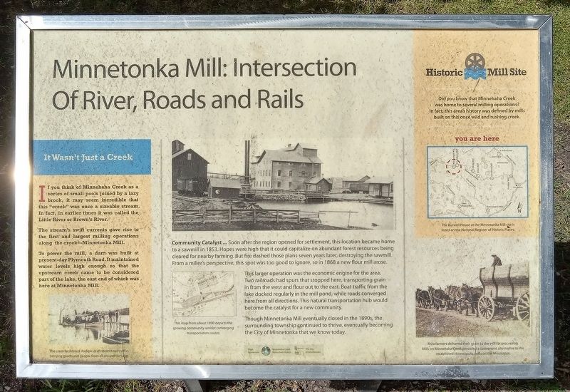
Minnetonka Mill: Intersection Of River, Roads and Rails
Photographed by McGhiever, September 7, 2025
1. Minnetonka Mill: Intersection Of River, Roads and Rails Marker
If you think of Minnehaha Creek as a series of small pools joined by a lazy brook, it may seem incredible that this "creek" was once a sizeable stream. In fact, in earlier times it was called the Little River or Brown's River.
The stream's swift currents gave rise to the first and largest milling operations along the creek Minnetonka Mill.
To power the mill, a dam was built at present-day Plymouth Road. It maintained water levels high enough so that the upstream creek came to be considered part of the lake, the east end of which was here at Minnetonka Mill.
The creek facilitated shallow-draft steamboat traffic, carrying goods and people from all around the lake.
Community Catalyst … Soon after the region opened for settlement, this location became home to a sawmill in 1853. Hopes were high that it could capitalize on abundant forest resources being cleared for nearby farming. But fire dashed those plans seven years later, destroying the sawmill. From a miller's perspective, this spot was too good to ignore, so in 1868 a new flour mill arose.
This larger operation was the economic
this page online
Though Minnetonka Mill eventually closed in the 1890s, the surrounding township continued to thrive, eventually becoming the City of Minnetonka that we know today.
This map from about 1890 depicts the growing community amidst converging transportation routes.
Did you know that Minnehaha Creek was home to several milling operations? In fact, this area's history was defined by mills built on this once wild and rushing creek.
The Burwell House at the Minnetonka Mill site is listed on the National Register of Historic Places.
Area farmers delivered their grain to the mill for processing. Mills on Minnehaha Creek provided a convenient alternative to the established Minneapolis mills on the Mississippi.
Erected by the Minnehaha Creek Watershed District and the City of Minnetonka.
Topics.

Photographed by McGhiever, September 7, 2025
2. Minnetonka Mill Marker (left) in Mills Park
Location. 44° 56.49′ N, 93° 26.735′ W. Marker is in Minnetonka, Minnesota, in Hennepin County. It is at the intersection of Minnetonka Boulevard and Burwell Drive, on the left when traveling east on Minnetonka Boulevard. The marker is in Mills Park, west of the gazebo. Touch for map. Marker is at or near this postal address: 13100 Minnetonka Boulevard, Hopkins MN 55305, United States of America. Touch for directions.

Regionally, this marker is in the Twin Cities Metropolitan Area. It is also in the American Midwest, in the Corn Belt, and in the Great River Road Region. Globally, it is in North America, the Western Hemisphere, the Western World, and the Anglosphere. Historically, it finds itself in what was once Rupert’s Land, the territory of the Mississippian Culture, and the Louisiana Purchase.
Other nearby markers. At least 8 other markers are within walking distance of this marker: C. M. Loring Tribute (a few steps from this marker); Welcome to Burwell Park (about 500 feet away, measured in a direct line); The Millpond (about 600 feet away); Mill Office & Workshop (about 600 feet away); The Burwell House and Family (about 600 feet away); Cottage (about 700 feet away); Woodshed (about 700 feet away); Ice House (about 700 feet away). Touch for a list and map of all markers in Minnetonka.
Credits. This page was last revised on November 19, 2025. It was originally submitted on November 19, 2025, by McGhiever of Minneapolis, Minnesota. This page has been viewed 59 times since then and 23 times this year. Photos: 1, 2. submitted on November 19, 2025, by McGhiever of Minneapolis, Minnesota.
