Perryville in Boyle County, Kentucky — The American South (East South Central)
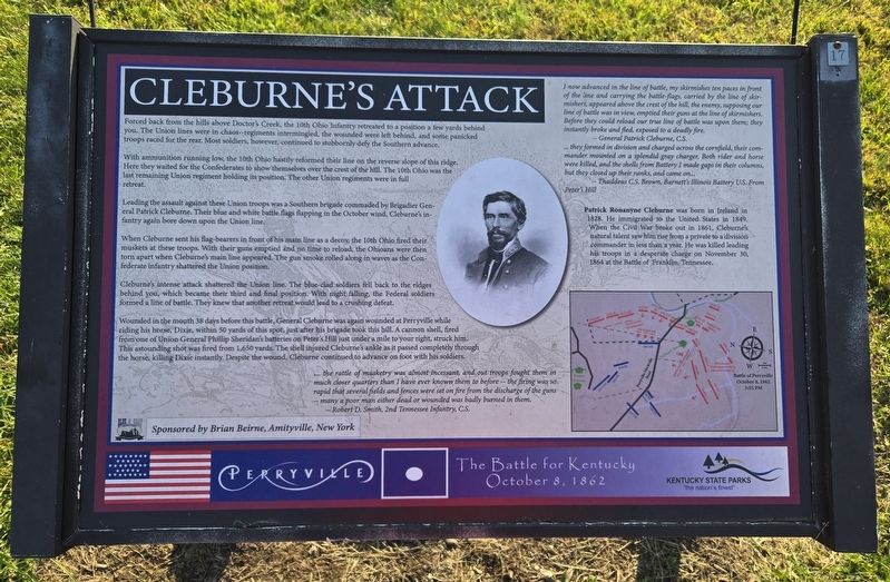
Cleburne's Attack
Perryville • The Battle For Kentucky
| — | October 8, 1862 | — |
Photographed by Bradley Owen, October 18, 2025
1. Cleburne's Attack Marker
Forced back from the hills above Doctor's Creek, the 10th Ohio Infantry retreated to a position a few yards behind you. The Union lines were in chaos--regiments intermingled, the wounded were left behind, and some panicked troops raced for the rear. Most soldiers, however, continued to stubbornly defy the Southern advance.
With ammunition running low, the 10th Ohio hastily reformed their line on the reverse slope of this ridge. Here they waited for the Confederates to show themselves over the crest of the hill. The 10th Ohio was the last remaining Union regiment holding its position. The other Union regiments were in full retreat.
Leading the assault against these Union troops was a Southern brigade commaded by Brigadier General Patrick Cleburne. Their blue and white battle flags flapping in the October wind, Cleburne's infantry again bore down upon the Union line.
When Cleburne sent his flag-bearers in front of his main line as a decoy, the 10th Ohio fired their muskets at these troops. With their guns emptied and no time to reload, the Ohioans were then torn apart when Cleburne's main line appeared. The gun
this page online
Cleburne's intense attack shattered the Union line. The blue-clad soldiers fell back to the ridges behind you, which became their third and final position. With night falling, the Federal soldiers formed a line of battle. They knew that another retreat would lead to a crushing defeat.
Wounded in the mouth 38 days before this battle, General Cleburne was again wounded at Perryville while riding his horse, Dixie, within 50 yards of this spot, just after his brigade took this hill. A cannon shell, fired from one of Union General Phillip Sheridan's batteries on Peter's Hill just under a mile to your right, struck him. This astounding shot was fired from 1,650 yards. The shell injured Cleburne's ankle as it passed completely through the horse, killing Dixie instantly. Despite the wound, Cleburne continued to advance on foot with his soldiers.
.... the rattle of musketry was almost incessant, and out troops fought them in much closer quarters than I have ever known them to before -- the firing was so rapid that several fields and fences were set on fire from the discharge of the guns -- many a poor man either dead or wounded was badly burned in them.
-- Robert D. Smith, 2nd Tennessee Infantry, C.S.
I now advanced in the line of battle, my skirmishes ten paces in front of the line and carrying the battle-flags, carried by the line of skirmishers, appeared above the crest of the hill, the enemy, supposing our line of battle was in view, emptied their guns at the line of skirmishers. Before they could reload our true line of battle was upon them; they instantly broke and fled, exposed to a deadly fire.
-- General Patrick Cleburne, C.S.
... they formed in division and charged across the cornfield, their commander mounted on a splendid gray charger. Both rider and horse were killed, and the shells from Battery I made gaps in their columns, but they closed up their ranks, and came on...
-- Thaddeus C.S. Brown, Barnett's Illinois Battery U.S. From Peter's Hill
Patrick Ronanyne Cleburne

Photographed by Bradley Owen, October 18, 2025
2. Cleburne's Attack Marker
The “Artillery Duel at Loomis Heights” marker is in the background.
Erected by Brian Beirne, Amityville, New York and Kentucky State Parks.
Topics. This historical marker is listed in this topic list: War, US Civil. A significant historical date for this entry is November 30, 1864.
Location. 37° 40.001′ N, 84° 58.296′ W. Marker is in Perryville, Kentucky, in Boyle County. It can be reached from Hays Mays Road 0.6 miles east of Whites Road, on the left when traveling east. Marker is located on the H.P. Bottom Farm Trail at the Perryville Battlefield State Historic Site. Touch for map. Marker is at or near this postal address: 1625 Hays Mays Road, Perryville KY 40468, United States of America. Touch for directions.

Regionally, this marker is in Kentucky’s Bluegrass Region. It is also in the American South and specifically in the Upper South. Globally, it is in North America, the Western Hemisphere, the Western World, and the Anglosphere. Historically, it finds itself in what was once the territory of the Mississippian Culture and also the Antebellum South.
Other nearby markers. At least 8 other markers are within walking distance of this marker: Artillery Duel at Loomis Heights (within shouting distance of this marker); Michigan at Perryville (within shouting distance of this marker); Assault From The Bottom House (about 400 feet away, measured in a direct line); The 15th Kentucky Infantry (Union) (about 400 feet away); “For God’s Sake, Save That Battery” The 38th Indiana at Perryville (about 500 feet away); Baptism of Fire: The 42nd Indiana Story (about 500 feet away); Simonson’s Battery (about 500 feet away); The H.P. Bottom House (about 500 feet away). Touch for a list and map of all markers in Perryville.
Other markers no longer nearby. Assault from the Bottom House (was within shouting distance of this marker but has been replaced with another marker now near it); The 15th Kentucky Infantry (US) (was within shouting distance of this marker but has been permanently removed); Baptism of Fire (was about 500 feet away but has been replaced with another marker now near it); The H. P. Bottom House (was about 500 feet away but has been replaced with another marker now near it).
Regarding Cleburne's Attack. Marker includes a portrait of Confederate General Patrick Cleburne and a map: Battle of Perryville, October 8, 1862, 3:55 PM.
Credits. This page was last revised on November 27, 2025. It was originally submitted on November 27, 2025, by Bradley Owen of Morgantown, West Virginia. This page has been viewed 107 times since then and 73 times this year. Photos: 1, 2. submitted on November 27, 2025, by Bradley Owen of Morgantown, West Virginia.
