Near Brandy Station in Culpeper County, Virginia — The American South (Mid-Atlantic)
The Battle of Brandy Station
Confederate Line of Defense at St. James Church
Photographed by Craig Swain, December 22, 2007
1. The Battle of Brandy Station Marker
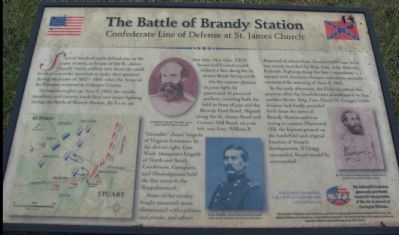
Several hundred yards behind you, in the copse of trees, is the site of the St. James Church. Union soldiers tore down the small brick structure for materials to make their quarters during the winter of 1863-1864, when the Army of the Potomac wintered in Culpeper County.
Six months earlier, on June 9, 1863, the woods, meadows, and country roads here saw major fighting during the Battle of Brandy Station. By 8 a.m. on that date, Maj. Gen. J.E.B. Stuart had formed a solid defensive line along the St. James Road, facing north.
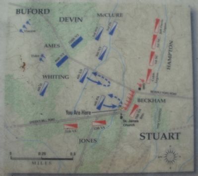
On the narrow plateau to your right, he positioned 16 pieces of artillery, covering both the field in front of you and the Beverly Ford Road. Aligned along the St. James Road and Green's Mill Road, on your left, was Gen. William E. "Grumble" Jones' brigade of Virginia horsemen. In the distant right, Gen. Wade Hampton's brigade of North and South Carolinians, Georgians, and Mississippians held the line towards the Rappahannock.
Some of the cavalry fought mounted, some dismounted with carbines and pistols, and others dispersed as skirmishers. Stuart's 5,000-man force was evenly matched by Brig. Gen. John
this page online
In the early afternoon, the Federals seized this position after the Confederates abandoned it to face another threat. Brig. Gen. David M. Gregg's Union division had had finally pounded forth from the town of Brandy Station and was trying to capture Fleetwood Hill, the highest ground on the battlefield and original location of Stuart's headquarters. If Gregg succeeded, Stuart would be surrounded.
Help Preserve Battlefields • call CWPT at 1-888-606-1400 • www.civilwar.org • The Hallowell Foundation generously contributed toward the interpretation of this site in memory of Carrington Williams.
This material is based upon work assisted by a grant from the Department of the Interior, National Park Service. Any opinion, findings and conclusions or recommendations expressed in this material are those of the author(s) and do not necessarily reflect the views of the Department of the Interior.
Erected by Civil War Preservation Trust.
Topics. This historical marker is listed in this topic
Photographed by Craig Swain, December 22, 2007
2. Battle Map
Location. Marker has been permanently removed. It was located near 38° 31.516′ N, 77° 52.044′ W. Marker was near Brandy Station, Virginia, in Culpeper County. It was at the intersection of St. James Church Road (Route 676) and Beverly Ford Road (Route 677), on the right when traveling west on St. James Church Road. Located at the fourth trail stop for the St. James Church Walking Trail of the the Battle of Brandy Station. Touch for map. Marker was at or near this postal address: 13056 St James Church Rd, Brandy Station VA 22714, United States of America.
We have been informed that this marker is no longer there and will not be replaced. This page is an archival view of what was.
Regionally, this marker was in the Washington Metropolitan Area and in Northern Virginia. It was also in the American South, specifically in the Upper South, and in the Mid-Atlantic. Globally, it was in North America, the Western Hemisphere, the Western World, and the Anglosphere. Historically, it found itself in what was once the territory of the Mississippian Culture, one of the

Photographed by Craig Swain, December 22, 2007
3. Trail Stop Four
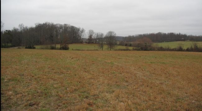
From the trail head, the marker is seen in the center in the field across the creek bed, is at trail stop four of the St. James Church walking tour. This photo was taken from stop one of the walking trail.
On the right is the copse of trees discussed on the marker, and the original site of St. James Church. Confederate artillery was positioned on the left side of the photo on the high ground just short of the copse of trees. Jones' Brigade extended from there along the road, to the north west.
On the right is the copse of trees discussed on the marker, and the original site of St. James Church. Confederate artillery was positioned on the left side of the photo on the high ground just short of the copse of trees. Jones' Brigade extended from there along the road, to the north west.
Other nearby markers. At least 8 other markers are within walking distance of this location: A different marker also named Battle of Brandy Station (about 300 feet away, measured in a direct line); St. James Episcopal Church (about 700 feet away); a different marker also named Battle of Brandy Station (approx. 0.2 miles away); The 1863-64 Winter Encampment (approx. 0.2 miles away); a different marker also named The Battle of Brandy Station (approx. ¼ mile away); a different marker also named Battle of Brandy Station (approx. ¼ mile away); a different marker also named Battle of Brandy Station (approx. ¼ mile away); Lee's Forgotten Warrior (approx. 0.3 miles away). Touch for a list and map of all markers in Brandy Station.
Other markers no longer nearby. The 1863-64 Winter Encampment (was approx. 0.2 miles away but has been permanently removed); a different marker also named Battle of Brandy Station (was approx. ¼ mile away but has been permanently removed).
More about this marker. On the lower left of the marker is a map
Photographed by Craig Swain, December 22, 2007
4. Hampton's Line
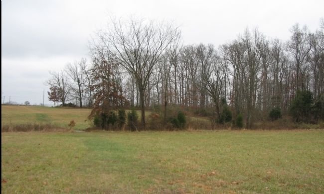
Gen. Stuart posted Hampton's Brigade along the road running from the center to the right edge of the photo. Hampton's line extended from a point here in the stand of trees, eastward nearly to present day Highway 15/29. From this point, the cavaliers had open fields of fire to the north, and blocked Federal Gen. Buford's advance down Beverly Ford Road.
Regarding The Battle of Brandy Station. This is one of several markers interpreting the Battle of Brandy Station and the winter encampments of 1863-64 in Culpeper County. See the Battle of Brandy Station Virtual Tour by Markers linked below for additional related markers.
Also see . . .
1. Battle of Brandy Station. National Park Service website entry (Submitted on December 30, 2007, by Craig Swain of Leesburg, Virginia.)
2. Brandy Station Foundation. Through the efforts of the Brandy Station Foundation, Civil War Preservation Trust, and other organizations, over 960 acres of this battlefield have been preserved. (Submitted on December 30, 2007, by Craig Swain of Leesburg, Virginia.)
3. Battle of Brandy Station Virtual Tour by Markers. A set markers that document the Battle of Brandy Station, June 9, 1863, and the Winter Encampment of 1863-64. Note the order of appearance is geographic and not chronologically aligned to the battle. (Submitted on January 1, 2008, by Craig Swain of Leesburg, Virginia.)
Credits. This page was last revised on November 29, 2025. It was originally submitted on December 25, 2007. This page has been viewed 2,926 times since then and 36 times this year. Last updated on November 29, 2025, by Mark P. Brock-Cancellieri of Baltimore, Maryland. Photos: 1, 2, 3. submitted on December 25, 2007, by Craig Swain of Leesburg, Virginia. 4. submitted on December 30, 2007, by Craig Swain of Leesburg, Virginia. • Devry Becker Jones was the editor who published this page.
