Belair-Edison in Baltimore, Maryland — The American Northeast (Mid-Atlantic)
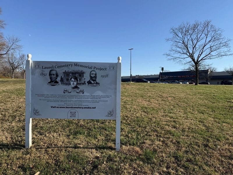
Laurel Cemetery Memorial Project
1852 - 1958

Photographed by Devry Becker Jones (CC0), November 29, 2025
1. Laurel Cemetery Memorial Project Marker
Laurel Cemetery (1852-1958) was a burial ground for thousands of African Americans. Despite protest, the cemetery was demolished, and several burials, monuments, and markers were relocated to Carroll County. A small number were privately moved to other cemeteries. However, the majority of burials remain at this site.
Laurel Cemetery Memorial Project seeks to create a memorial in recognition of this site, and to research and teach about the rich history of the cemetery and the lives of those buried here.
Learn more, support the work, and get involved:
Visit us www.laurelcemetery.omeka.net
Erected 2025 by Laurel Cemetery Memorial Project, Inc.
Topics. This historical marker is listed in these topic lists: African Americans • Cemeteries & Burial Sites. A significant historical year for this entry is 1852.
Location. 39° 19.141′ N, 76° 34.579′ W. Marker is in Baltimore, Maryland. It is in Belair-Edison. It is on Belair Road (U.S. 1) south of Clifmont Avenue, on the right when traveling north. Touch for map. Marker is at or near this postal address: 2801 Belair Rd, Baltimore MD
this page online

Regionally, this marker is in Central Maryland. It is also in the American Mid-Atlantic, in the Chesapeake Bay Region, and on the Eastern Seaboard. Globally, it is in the North Atlantic Region, North America, the Western Hemisphere, the Western World, and the Anglosphere. Historically, it finds itself in what was once one of the original Thirteen Colonies and also the Antebellum South.
Other nearby markers. At least 8 other markers are within walking distance of this marker: Mounted Messengers (approx. 0.6 miles away); The Samuel and Anne Hopkins Grand Staircase and Tower Restoration, Clifton Mansion (approx. 0.6 miles away); Colored Citizen's League Holds Jubilee! (approx. 0.6 miles away); World War I Memorial (approx. 0.6 miles away); Neil Abraham's Gateway Garden (approx. 0.7 miles away); The Stone Lodge & The Heritage Trail (approx. ¾ mile away); Estates Divide Creating Herring Run Park (approx. ¾ mile away); 11,000 Year Old Campsite Along Heritage Trail (approx. 0.8 miles away). Touch for a list and map of all markers in Baltimore.
Also see . . . Laurel Cemetery Memorial Project Website.
Photographed by Devry Becker Jones (CC0), November 29, 2025
2. Laurel Cemetery Memorial Project Marker
The marker stands on the grounds of the Belair-Edison Crossing strip mall.
The site shares the history of the cemetery and the project to share stories of individuals currently and formerly interred in the cemetery that was turned into a strip mall in the 1950s. The following introduction is from the site:
Laurel Cemetery (1852-1958) existed for over 100 years as a nonsectarian cemetery for Baltimore's African American community. In its early years, it was a premier burial site for people across Black Baltimore’s socioeconomic spectrum. However, years of improper maintenance led to the eventual demolition of the site in 1958. Today, the Belair-Edison Crossing shopping center occupies the footprint of the old cemetery.(Submitted on November 29, 2025, by Devry Becker Jones of Washington, District of Columbia.)
In spring 2014, University of Baltimore and Coppin State University professors initiated the Laurel Cemetery project as an inter-institutional project for students interested in cultural resource management, history, archaeology, and environmental sustainability. Through archaeological excavation, faculty and student researchers found conclusive evidence of existing burials. Their current efforts focus on public education, research into the lives of those buried at the site, and the erection of a memorial to recognize the burial ground.
Credits. This page was last revised on November 29, 2025. It was originally submitted on November 29, 2025, by Devry Becker Jones of Washington, District of Columbia. This page has been viewed 79 times since then and 43 times this year. Photos: 1, 2. submitted on November 29, 2025, by Devry Becker Jones of Washington, District of Columbia.
