Elora in Wellington County, Ontario — Central Canada (North America)
Elora Cenotaph
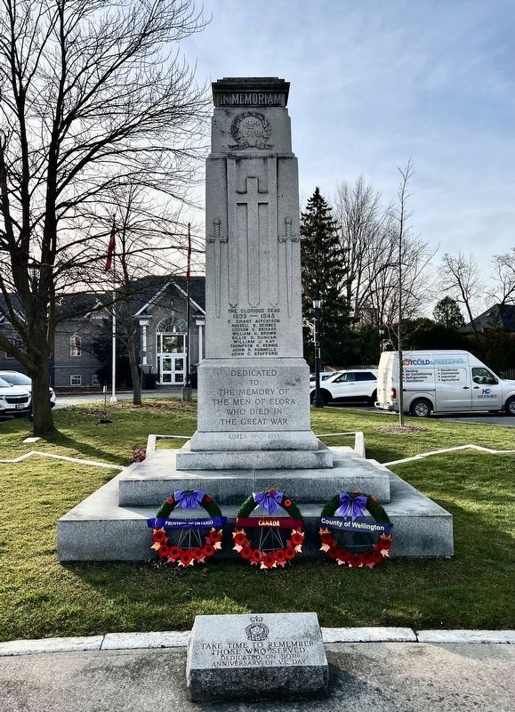
Photographed by Tim Boyd, November 24, 2025
1. Elora Cenotaph (east side)
[east side]
In Memoriam
The Glorious Dead
1939 - 1945
E. Grant Aitchison · Russell B. Beirnnes · Gordon C. Bricker · William Brown · Billie C. Duncan · William J. Kay · Thomson H. Rennie · John R. Runnells · John C. Stafford
Dedicated to the memory of the men of Elora who died in the Great War
Korea 1950-1953
[west side]
“My marks and scars I carry with me to be a witness for me that I have fought his battles who now will be my rewarder" So he passed over and all the trumpets sounded for him on the other side.
[south side]
Passchendaele · Amiens · Arras · Cambrai · Mons
The Glorious Dead
Chalres A. Card · Daniel O. Card · Robert G. Carter · F. Keith Clark · Richard H. Clarke · Lewis Clegg · William W. Cuthburt · Garfield Cutting · Stanley Dickinson · James C. Fisher
[north side]
Ypres · Festubert · Mt. Sorrel · Somme · Vimy
The Glorious Dead
Harry Halls · Harry Harpin · Fred F. MacDonald · John A. MacDonald · Archie Miller · Edward Morfee · James Moynihan · Charles McGowan · Harold J. Riley · Alfred Vincent
Topics.
this page online
Location. 43° 40.995′ N, 80° 25.841′ W. Memorial is in Elora, Ontario, in Wellington County. It is at the intersection of Geddes Street and Metcalfe Street, on the right when traveling south on Geddes Street. Touch for map. Memorial is at or near this postal address: 1 Macdonald Square, Elora ON N0B 1S0, Canada. Touch for directions.

Regionally, this memorial is in the Huron-Perth-Waterloo-Wellington Area and in Southwestern Ontario. It is also in Central Canada. Globally, it is in North America, the Western Hemisphere, the Western World, and the Anglosphere. Historically, it finds itself in what was once a British colony, the Viceroyalty of New France, the Haudenosaunee (Iroquois) Confederacy, and Rupert’s Land.
Other nearby markers. At least 8 other markers are within walking distance of this marker: The Founder of Elora (a few steps from this marker); The Village Centre (a few steps from this marker); The Village Drinking Fountain (within shouting distance of this

Photographed by Tim Boyd, November 24, 2025
2. Elora Cenotaph (west side)

Photographed by Tim Boyd, November 24, 2025
3. Elora Cenotaph (south side)

Photographed by Tim Boyd, November 24, 2025
4. Elora Cenotaph (north side)

Photographed by Tim Boyd, November 24, 2025
5. The Elora Cenotaph in 2025
Credits. This page was last revised on December 6, 2025. It was originally submitted on December 3, 2025, by Tim Boyd of Hamilton, Ontario. This page has been viewed 36 times since then and 14 times this year. Photos: 1, 2, 3, 4, 5. submitted on December 3, 2025, by Tim Boyd of Hamilton, Ontario. • Andrew Ruppenstein was the editor who published this page.
