
Willey Lumber Camp in Jackson County, Colorado — The American Mountains (Southwest)
The Industrial Frontier
Photographed by Cosmos Mariner, July 31, 2025
1. The Industrial Frontier Marker
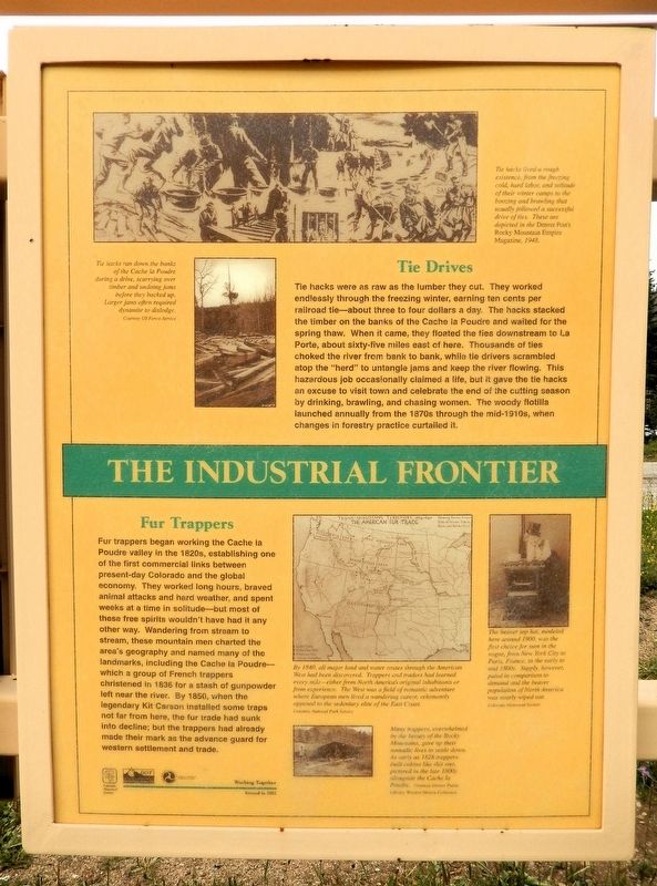
Tie Drives
Tie hacks were as raw as the lumber they cut. They worked endlessly through the freezing winter, earning ten cents per railroad tie — about three to four dollars a day. The hacks stacked the timber on the banks of the Cache la Poudre and waited for the spring thaw. When it came, they floated the ties downstream to La Porte, about sixty-five miles east of here. Thousands of ties choked the river from bank to bank, while tie drivers scrambled atop the “herd” to untangle jams and keep the river flowing. This hazardous job occasionally claimed a life, but it gave the tie hacks an excuse to visit town and celebrate the end of the cutting season by drinking, brawling, and chasing women. The woody flotilla launched annually from the 1870s through the mid-1910s, when changes in forestry practice curtailed it.
Fur Trappers
Fur trappers began working the Cache la Poudre valley in the 1820s, establishing one of the first commercial links between present-day Colorado and the global economy. They worked long hours, braved animal attacks and hard weather and spent weeks at a time in solitude — but most of these free spirits
this page online
[photo captions]
• Tie hacks lived a rough existence, from the freezing cold, hard labor, and solitude of their winter camps to the boozing and brawling that usually followed a successful drive of ties. These are depicted in the Denver Post’s Rocky Mountain Empire Magazine, 1948.
• Tie hacks ran down the banks of the Cache la Poudre during a drive, scurrying over timber and undoing jams before they backed up. Larger jams often required dynamite to dislodge.
• By 1840, all major land and water routes through the American West had been discovered. Trappers and traders had learned every mile — either from North America’s original inhabitants or from
Photographed by Cosmos Mariner, July 29, 2025
2. The Industrial Frontier Marker
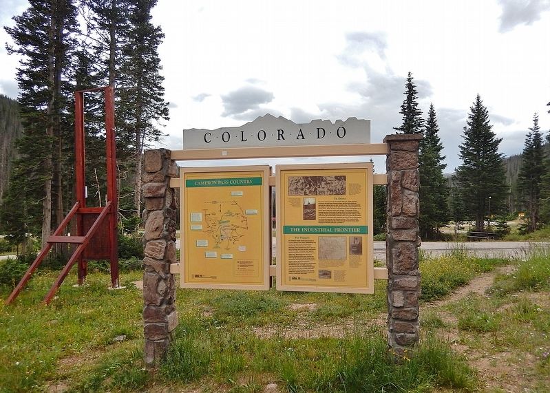
This marker is the rightmost of two panels on the north side of the Colorado Department of Transportation interpretive kiosk in the Cameron Pass wayside.
• Many trappers, overwhelmed by the beauty of the Rocky Mountains, gave up their nomadic lives to settle down. As early as 1828 trappers built cabins like this one, pictured in the late 1800s alongside the Cache la Poudre.
• The beaver top had, modeled here around 1900, was the first choice for men in the vogue, from New York City to Paris, France, in the early to mid 1800s. Supply, however, paled in comparison to demand and the beaver population of North America was nearly wiped out.
Erected 2002 by Colorado Historical Society, Colorado Department of Transportation and Federal Highway Administration.
Topics and series. This historical marker is listed in these topic lists: Industry & Commerce • Settlements & Settlers • Waterways & Vessels. In addition, it is included in the History Colorado series list. A significant historical year for this entry is 1828.
Location. 40° 31.237′ N, 105° 53.615′ W. Marker is in Willey Lumber Camp, Colorado, in Jackson County. It is on State Highway 14 at milepost 64.9, on the left when traveling east. The marker is in the Cameron Pass Summit wayside. Touch for map. Marker is in this post office area: Walden CO 80480, United States of America. Touch for directions.

Regionally, this marker is in the Colorado High Rockies and on the Continental Divide. It is also in the American Mountain West. Globally, it is in North America, the Rocky Mountains, the Western Hemisphere, the Western World, and the Anglosphere.
Other nearby markers. At least 8 other markers are within 9 miles of this marker, measured as the crow flies: Auto Tourism (here, next to this marker); Cameron Pass Country (here, next to this marker); Forest Conservation (here, next to this marker); Joe Wright Reservoir (approx. 1.4 miles away); Poudre Pioneer Tourism (approx. 1.4 miles away); Get to Know your Native Greenback Cutthroat Trout (approx. 1.4 miles away); The Colorado State Forest Management Complex (approx. 4 miles away); Beaver Trade (approx. 8.2 miles away). Touch for a list and map of all markers in Willey Lumber Camp.
Also see . . . Pre-settlement Water, Land, People Relationships in the Poudre River Valley (Poudre Heritage).
Excerpt: The Poudre River’s recorded history, prior to gold seekers and settlers arriving in the late 1850s and early 1860s, is scarce. There were fur trappers’ and explorers’ writings of the area, but these were very limited regarding the Poudre River. It was during this period that the river obtained its name, but the exact reasons and timing are uncertain. It is generally agreed that fur traders/trappers needed to stash some of their supplies (including gun powder – in French it becomes ‘Cache la Poudre’), for a short time, during the 1820s or 1830s, for some reason, and the river was named for this action.(Submitted on December 9, 2025, by Cosmos Mariner of Cape Canaveral, Florida.)
Credits. This page was last revised on December 9, 2025. It was originally submitted on December 8, 2025, by Cosmos Mariner of Cape Canaveral, Florida. This page has been viewed 86 times since then and 53 times this year. Photos: 1. submitted on December 8, 2025, by Cosmos Mariner of Cape Canaveral, Florida. 2. submitted on December 9, 2025, by Cosmos Mariner of Cape Canaveral, Florida.
