Heart of Chicago in Cook County, Illinois — The American Midwest (Great Lakes)
Marquette and Jolliet Memorial
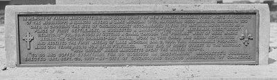
Charles R. Clark, photographer; courtesy of Chicago History Museum (ICHi-068311), circa 1908
1. Marquette and Jolliet Memorial Marker
"To go and suffer everything for so glorious an undertaking" Marquette's journal.
Erected Sat., Sept 28, 1907 by City of Chicago, and Chicago Association of Commerce.
Erected 1907 by City of Chicago; Chicago Association of Commerce.
Topics. This historical marker and memorial is listed in these topic lists: Exploration • Industry & Commerce •
this page online
Location. Marker has been reported permanently removed. It was located near 41° 50.539′ N, 87° 40.504′ W. Marker was in Chicago, Illinois, in Cook County. It was in Heart of Chicago. It could be reached from Damen Avenue (known previously as Robey Street) 0.4 miles north of Stevenson Expressway (Interstate 55), on the right when traveling north. Touch for map. Marker was in this post office area: Chicago IL 60608, United States of America.
We have been informed that this marker is no longer there and will not be replaced. This page is an archival view of what was.
Regionally, this marker and memorial was on Chicago’s West Side. It was also in the American Midwest. Globally, it was in North America, on the Great Lakes, in the Western Hemisphere, in the Western World, and in the Anglosphere. Historically, it found itself in what was once the Viceroyalty of New France, the territory of the Mississippian Culture, and the Northwest Territory.

Other nearby markers. At least 8 other markers are within walking distance of this
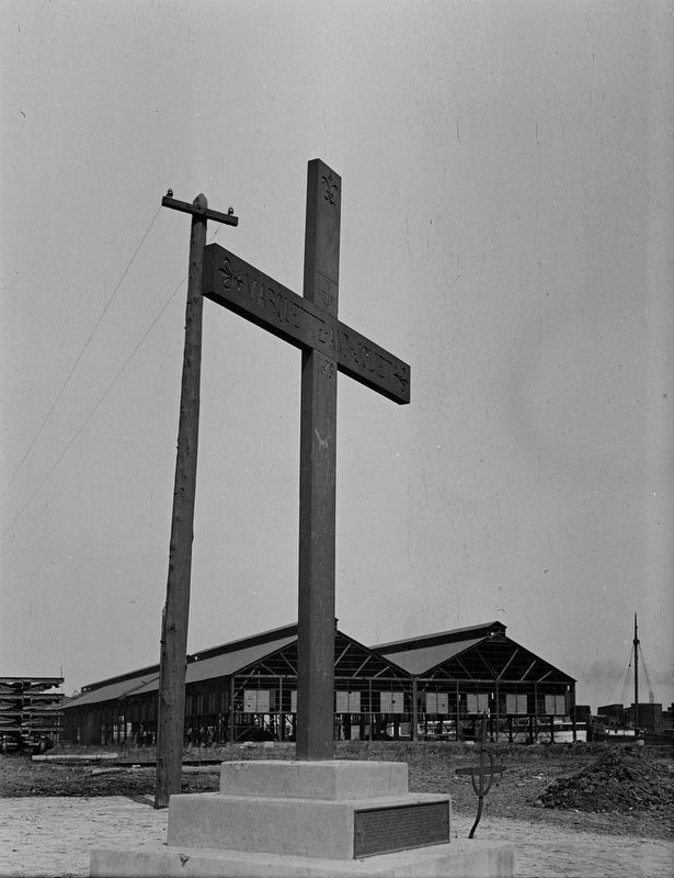
Chicago Daily News collection, Chicago History Museum, circa 1908
2. Marquette and Jolliet Memorial
The wooden cross pictured here is the first one at the site. It was sawed off by vandals in 1914, and replaced the next year by a new cross. This one is engraved with “Marquette and Joliet 1673” and features three fleurs-de-lys, a nod to the explorers’ French heritage. Also visible in this photo is a smaller metal cross that some people believed to have been left by Marquette at this site.
More about this marker. The plaque was at the base of a large cross that overlooked the Chicago River's South Branch, marking both the end of Jacques Marquette and Louis Jolliet's "portage" route referenced on the plaque and, as also stated, the site of Marquette's winter quarters during his 1674-75 mission to connect with the Illinois Indians.
The location listed above is an estimate, based on a variety of sources about the cross. It is not known if this plaque still survives, and if so where it is housed. Also, although it's hard to make out for absolute certain, it appears that Jolliet's name is spelled with only one "L," mirroring how he is memorialized in the namesake city southwest of

Photographed by Sean P. Flynn, October 20, 2024
3. James Marquette Marker
The 1930 memorial to Fr. Marquette is on the north side of the Damen Avenue bridge over the Chicago River, near the Banner Foods warehouse. The cross was most likely somewhere near where that warehouse is today.
The cross and plaque were first erected in 1907 by the city and its business leaders. In 1914, vandals sawed off the cross; it was replaced the following year. In 1924, the city fully removed the memorial in order to create a new crossing for Robey Street over the river. (Robey Street was renamed Damen Avenue in 1927, after the priest who founded Loyola University and St. Ignatius High School.) After the bridge was completed, a new memorial was erected in 1930 on the new Damen Avenue bridge, honoring only Fr. Marquette's winter camp at this site. The bridge was later expanded again, and that 1930 memorial was moved to a spot north of the bridge on the east side of Damen Avenue. That marker remains in that spot as of at least 2024. Meanwhile, another cross was erected near the bridge in the 1970s, but it was removed by the 2000s.
Photographs related to the erection of this cross in 1907 also show a smaller metal cross immediately next to it. According to one caption from the Chicago History Museum, an unconfirmed story said that the cross had been found by crews excavating the area nearby, and that they believed

Chicago Daily News collection, Chicago History Museum, May 1915
4. Marquette and Jolliet Cross
The plaque was on the opposite side of the base, facing the river. The cross pictured here is the second one at this site, installed in 1915 after the first one (from 1908) was sawed off by vandals. The cross is printed with the words: "In memory of Marquette and Joliet, 1673."
Regarding Marquette and Jolliet Memorial. Fr. Jacques Marquette made two visits to this location on what today is Chicago's southwest side. In 1673, Fr. Marquette and his fellow explorer, the fur trader Louis Jolliet, traveled from Wisconsin to the Mississippi River, reaching the Arkansas River, far enough to confirm that the Mississippi River did indeed drain into the Gulf of Mexico. To avoid capture by the Spanish, the pair turned around to return to Wisconsin. Their return route took them up the Illinois River, to the Des Plaines, which at its closest point is about 11 miles west of Lake Michigan. From the Des Plaines River near modern day Summit, Illinois, Fr. Marquette and Jolliet "portaged" — carried their canoes over land — to the South Branch of the Chicago River, which then returned them to Lake Michigan. As referenced on this plaque, Jolliet is credited with suggesting after this trip that a canal could be built here to connect
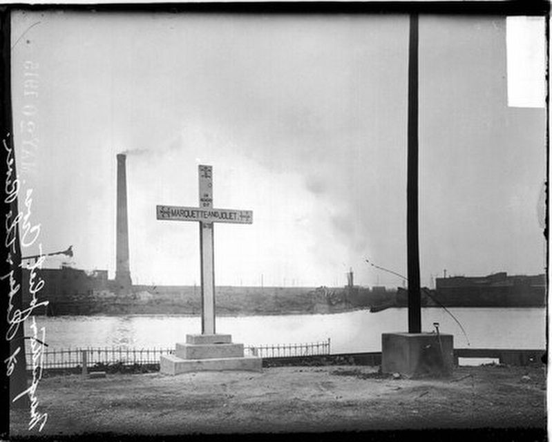
Chicago Daily News collection, Chicago History Museum (DN-0064451), May 15, 1915
5. Marquette and Jolliet Memorial along the Chicago River's south branch
The photo appears to date to the dedication of a new cross in 1915, replacing the 1907 version that had been sawed off by vandals.
In the winter of 1674-75, Fr. Marquette set out on another journey to connect with, and preach to, the Illinois Indians who were in Central Illinois. Marquette, traveling with two companions, reached Chicago in late 1674, but with winter setting in, decided to encamp near this spot on the Chicago River's South Branch. Marquette and his party stayed here for about four months, until the March thaw flooded their camp and forced them to resume their journey. Marquette eventually did reach the Illinois, not far from the modern day location of Starved Rock State Park, but by that point he was gravely ill, likely from dysentery he had picked up during his 1673 journey with Jolliet. He died while returning home, near modern-day Ludington, Michigan.
This site where Marquette spent the winter of 1674-75 has, of course, changed considerably since 1675, although less so since this cross and plaque were erected in the early 1900s. Jolliet's vision for a canal came to fruition in 1848 with the completion
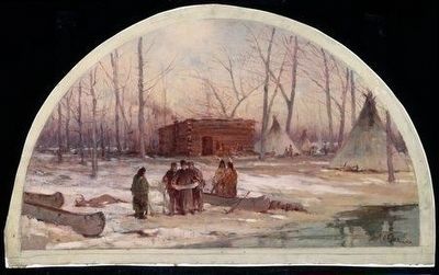
Painting by Lawrence C. Earle; Courtesy of Chicago History Museum (ICHi-062501), circa 1900
6. "The Winter Quarters of Father Marquette, 1674"
A 1900 painting by Lawrence C. Earle depicts Marquette's 1674-75 winter camp, which was located roughly where the modern Damen Avenue meets the Chicago River.
Also see . . .
1. The Marquette and Jolliet "Cross" Chicago, Illinois. 1907. The Digital Research Library of Illinois History Journal website looks at the history of the Marquette and Jolliet Cross that, for about 15 years, stood at the site of Marquette's 1674-5 winter encampment. The article includes archival photos related to memorials on the site, including another cross that was erected next to the modern bridge in the 1970s but removed by the 2000s. (Submitted on December 9, 2025, by Sean P. Flynn of Oak Park, Illinois.)
2. WTTW-11 (Chicago): Marquette Cross. A segment of "Chicago Time Machine" reviews the history of the "Marquette Cross" and the voyages of Marquette and Jolliet through Chicago in the 1670s. (Submitted on December 10, 2025, by Sean P. Flynn of Oak Park, Illinois.)
3. The Mississippi Voyage of Jolliet and Marquette, 1673. Soon after returning to De Pere, Wisconsin, after his four-month exploration of the Mississippi River with fur trader Louis Jolliet in 1673, Fr. Jacques Marquette wrote an account of the journey. While an abridged version was published in France around 1681, Marquette's full journal sat untouched in the archives of the Jesuit convent in Montreal until being found again more than 150 years later. In 1852, they were published in English for the first time. This link goes to the 1899 edition of Marquette's travels. (Submitted on December 10, 2025, by Sean P. Flynn of Oak Park, Illinois.)
Credits. This page was last revised on December 14, 2025. It was originally submitted on December 9, 2025, by Sean P. Flynn of Oak Park, Illinois. This page has been viewed 210 times since then and 160 times this year. Photos: 1, 2. submitted on December 9, 2025, by Sean P. Flynn of Oak Park, Illinois. 3. submitted on October 21, 2024, by Sean P. Flynn of Oak Park, Illinois. 4, 5. submitted on December 9, 2025, by Sean P. Flynn of Oak Park, Illinois. 6. submitted on October 17, 2024, by Sean P. Flynn of Oak Park, Illinois.
