Olde Town Arvada in Jefferson County, Colorado — The American Mountains (Southwest)
Small Town with Big City Ties
| — | Historic Olde Town Walking Tour | — |

Photographed by Susan Fishburne, November 21, 2025
1. Small Town with Big City Ties Marker
Small Town with Big City Ties
Well Connected
From wagon trails to railroad lines, city streets to interstate highways, Arvada’s transportation network connects us to the world.
Travel by Trolley
This railroad line has been in use for more than a hundred years.
In 1902, the Denver interurban, fondly called the “trolley,” began regular service from Arvada to Denver. Its electric-powered cars ran “every hour on the hour” and carried both coal and passengers until 1950.
A Car-Centered Culture
With the increased availability of cars, people could easily live in Arvada and commute to Denver or another nearby community.
In fact, the very first stoplight in Jefferson County was installed at the intersection of Grandview and Wadsworth in 1941.
An Integral Link in a Changing Landscape
As the population of the Denver metropolitan area continues to grow, Arvada is a solid link in the regional transportation network.
Modern bus lines and the Gold Line are an important part of a successful regional transportation system.
Topics. This historical marker is listed in these topic lists: Industry & Commerce
this page online
Location. 39° 47.948′ N, 105° 4.82′ W. Marker is in Arvada, Colorado, in Jefferson County. It is in Olde Town Arvada. It is on Grandview Avenue, on the right when traveling east. At the Olde Town RTD light rail station. Touch for map. Marker is in this post office area: Arvada CO 80002, United States of America. Touch for directions.

Regionally, this marker is in the Front Range. It is also in the American Mountain West. Globally, it is in North America, the Rocky Mountains, the Western Hemisphere, the Western World, and the Anglosphere. Historically, it finds itself in what was once the Louisiana Purchase.
Other nearby markers. At least 8 other markers are within walking distance of this marker: Supported by Agriculture (here, next to this marker); Sparked by Gold (here, next to this marker); Historic Olde Town's Buildings (within shouting distance of this marker); Arvada Celebrates (within shouting distance of this marker); A Grand View (within shouting distance of this marker); Wadsworth Boulevard

Photographed by Susan Fishburne, November 21, 2025
2. Small Town with Big City Ties Marker Wide angle view

1950
3. Travel by Trolley
Trolley top left: The Denver Tramway .04 streetcar waits for passengers at the end of the line at Vance Ave., just south of the current railroad tracks. This was the last car to operate in Arvada when service ended on July 2, 1950, Courtesy of the Tom Klinger Collection.
Photographed by Susan Fishburne, November 21, 2025
4. An Integral Link in a Changing Landscape
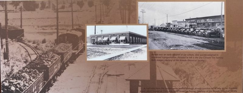
Bottom: Arvada was an early adopter of car culture, and quickly adapted to motorized transportation. Pictured at left is the Dry Climate Tire Factory. Both images courtesy of the Arvada Historical Society.
A coal train from the Leyden mines passes through Arvada Junction on its way to the Tramway power plant located at 15th and Platte streets in Denver. Courtesy of the Arvada Historical Society.
Credits. This page was last revised on January 6, 2026. It was originally submitted on December 28, 2025, by Susan Fishburne of Lakewood, Colorado. This page has been viewed 57 times since then and 34 times this year. Photos: 1, 2, 3, 4. submitted on December 28, 2025, by Susan Fishburne of Lakewood, Colorado. • Andrew Ruppenstein was the editor who published this page.
