Olde Town Arvada in Jefferson County, Colorado — The American Mountains (Southwest)
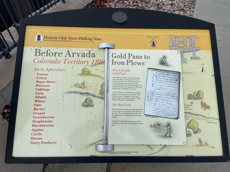
Before Arvada
Colorado Territory 1866
| — | Historic Olde Town Walking Tour | — |
Photographed by Susan Fishburne, November 21, 2025
1. Before Arvada Marker
Early Agriculture
Onions • Celery • Sugar Beets • Potatoes • Cabbage • Corn • Alfalfa • Wheat • Oats • Barley • Grapes • Strawberries • Raspberries • Blackberries • Apples • Cattle • Horses • Dairy Products
Gold Pans to Iron Plows
First Colorado Gold Find!
Lewis Ralston, member of a Georgia wagon train, made the first documented Colorado gold find on June 22nd, 1850. The party was traveling through the ancient lands of the Arapaho Indians on the trail to California. This discovery brought the prospectors of 1858 and triggered the development of our state.
"June 22 Lay Bye. Gold found. We called this Ralston’s Creek because a man of that name found gold here.” (Caption on diary entry: John Lowery Brown’s diary. June 22, 1850) Gilcrease Institute, Tulsa Oklahoma.
The Real Gold
Pioneers headed west for new opportunities and many prospectors turned from gold panning to plowing. They realized that the real gold was the fertile soil of the Ralston and Clear Creek Valleys.
Prospectors wrote home encouraging family and friends to join them and to bring plows and seeds.
A Fertile Valley
Livelihoods Changed
In
this page online
Family Farms
In 1860 George C. Swadley grew Arvada’s first successful crop – Onions! Pioneer families followed his lead, reaping rich harvests of grain, fruit and vegetable crops. Hungry gold camp miners and Denver city dwellers were a ready market for Arvada crops. U.S. Presidents have dined on Arvada’s famous Pascal celery.
Precious Water
The irrigation water from Ralston and Clear Creeks were so precious that people claimed rights to its use. Ditch companies were the first form of self-government in the Arvada area. As early as 1859, they established water rights for their users.
Ditch irrigation is still important today for the many active farms near Arvada. Ditch riders on horseback regularly monitor water use.
Topics. This historical marker is listed in these topic lists: Agriculture • Industry & Commerce • Settlements & Settlers. A significant historical date for this entry is June 22, 1850.
Location. 39° 47.9′ N, 105° 4.882′ W. Marker is in Arvada, Colorado, in Jefferson County. It is

Photographed by Susan Fishburne, November 21, 2025
2. Before Arvada Marker wide angle view

Regionally, this marker is in the Front Range. It is also in the American Mountain West. Globally, it is in North America, the Rocky Mountains, the Western Hemisphere, the Western World, and the Anglosphere. Historically, it finds itself in what was once the Louisiana Purchase.
Other nearby markers. At least 8 other markers are within walking distance of this marker: Arvada-Pride Flour Mill (a few steps from this marker); Arvada Water Tower (a few steps from this marker); Bountiful Harvest (a few steps from this marker); Wadsworth Boulevard (about 300 feet away, measured in a direct line); Small Town with Big City Ties (about 400 feet away); Supported by Agriculture (about 400 feet away); Sparked by Gold (about 400 feet away); Historic Olde Town's Buildings (about 600 feet away). Touch for a list and map of all markers in Arvada.
More about this marker. The marker stands across the street from the Arvada Flour Mill.
Credits. This page was last revised on January 6, 2026. It was originally submitted on December 28, 2025, by Susan Fishburne of Lakewood, Colorado. This page has been viewed 88 times since then and 52 times this year. Photos: 1, 2. submitted on December 28, 2025, by Susan Fishburne of Lakewood, Colorado. • Devry Becker Jones was the editor who published this page.
