Near Marion in Marion County, Ohio — The American Midwest (Great Lakes)
World War II Displacement
"The Old Farm Went to War"

Photographed by William Fischer, Jr., April 19, 2008
1. World War II Displacement Marker (Side A)
Side A:
During the early months of World War II, citizens as well as soldiers made enormous sacrifices for the war effort. In March 1942 the War Department announced plans to build a 13,000-acre munitions manufacturing complex northeast of Marion. Using the power of eminent domain, the U.S. Government purchased the homes and farms of 126 families in the Likens Chapel community. Given only two months to vacate their property, many displaced farmers found the government-appraised values for their land inadequate for buying similar farms elsewhere and [the] growing season too advanced to plant new crops.
(Continued on other side)
Side B:
(Continued from other side)
The Scioto Ordnance Plant began assembling bombs, shells, and fuses in late fall 1942. It was phased out after only one year as its production became surplus. The adjacent Marion Engineer Depot continued operations for the duration of the war, serving as a distribution point for war material and also as a prisoner-of-war camp. Likens Chapel and cemetery, which stand ½ mile north, is one of few remnants of an entire community sacrificed for the war effort.
this page online
Erected 2000 by Ohio Bicentennial Commission, The Longaberger Company, City of Marion, Marion Municipal Airport and The Ohio Historical Society. (Marker Number 9-51.)
Topics and series. This historical marker is listed in these topic lists: Agriculture • Industry & Commerce • Patriots & Patriotism • Settlements & Settlers • War, World II. In addition, it is included in the Ohio Historical Society / The Ohio History Connection series list. A significant historical month for this entry is March 1942.
Location. 40° 36.923′ N, 83° 4.387′ W. Marker is near Marion, Ohio, in Marion County. It is at the intersection of Pole Lane Road (County Road 174) and Chapel Heights Street, on the right when traveling north on Pole Lane Road. Marker is at the entrance to the Marion Municipal Airport. Touch for map. Marker is at or near this postal address: 1530 Pole Lane Road, Marion OH 43302, United States of America. Touch for directions.

Regionally, this marker is in the Scioto Valley and in the

Photographed by William Fischer, Jr., April 19, 2008
2. World War II Displacement Marker (Side B)
Other nearby markers. At least 8 other markers are within 4 miles of this marker, measured as the crow flies: Camp Marion, World War II Prisoners of War (approx. 1.4 miles away); The Marion Engineer Depot (approx. 1.4 miles away); Scioto Ordnance Plant Site (approx. 1.7 miles away); Marion Women’s Club Home (approx. 2.3 miles away); Claridon Prairie (approx. 2.3 miles away); Marion Mausoleum (approx. 2.7 miles away); NASA’s Crawler-Transporter Tread Shoe (approx. 2.7 miles away); Cummin's Home (approx. 3.1 miles away). Touch for a list and map of all markers in Marion.
Also see . . . Scioto Ordnance Plant. Wikipedia entry (Submitted on March 26, 2010, by William Fischer, Jr. of Reynoldsburg, Ohio.)
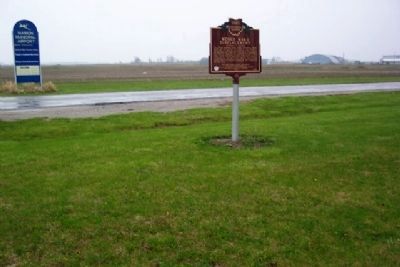
Photographed by William Fischer, Jr., April 19, 2008
3. World War II Displacement Marker
Looking NE.
Credits. This page was last revised on July 11, 2022. It was originally submitted on March 26, 2010, by William Fischer, Jr. of Reynoldsburg, Ohio. This page has been viewed 2,501 times since then and 90 times this year. Photos: 1, 2, 3. submitted on March 26, 2010, by William Fischer, Jr. of Reynoldsburg, Ohio.
Editor’s want-list for this marker. Photo of the ruins of Likens Chapel (Likens Church) and its cemetery which is one mile north at the intersection with Likens Road • Can you help?
