Near Clarkesville in Habersham County, Georgia — The American South (South Atlantic)
Living & Learning In The Mountains
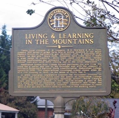
Photographed by David Seibert, October 22, 2005
1. Living & Learning In The Mountains Marker
Three local citizens, W. M. Loggans, B. B. Heyward and W. P. Furr, donated 300 acres of prime farm land to entice location of the Ninth District School of Agriculture and Mechanic Arts, a boarding high school, on this site. Since 1906, thousands have come here to learn a wide range of subjects. Here they made new friends, formed lifelong relationships and prepared for good livelihoods. “The A & M School" operated until 1933; closing due to the Great Depression.
Habersham School Supt. Claude Purcell purchased the site from the state for a dollar and due to his foresight and with the support of President Roosevelt’s National Youth Administration, Habersham College opened in 1938. The coeducational vocational school closed when the NYA lost funding in 1943, in the midst of World War II.
In 1943, Georgia Legislature created the Vocational Division of the Dept. of Education which used the assets of Habersham College to open the first state ~ operated technical school, North Georgia Trade and Vocational School. In 1985, NGTVS became a part of the new State Board of Technical and Adult Education and today the name is North
this page online
Erected 1993 by Georgia Department of Natural Resources. (Marker Number 068-11.)
Topics and series. This historical marker is listed in these topic lists: Agriculture • Education • Industry & Commerce • War, World II. In addition, it is included in the Georgia Historical Society series list. A significant historical year for this entry is 1906.
Location. This marker has been replaced by another marker nearby. It was located near 34° 38.336′ N, 83° 31.849′ W. Marker was near Clarkesville, Georgia, in Habersham County. It was on Georgia Route 197 0.1 miles south of Sutton Mill Road, on the right when traveling north. Marker is at the entrance to the North Georgia Technical Institute. Touch for map. Marker was at or near this postal address: 1500 Highway 197 North, Clarkesville GA 30523, United States of America. Touch for directions.

Regionally, this marker was in Georgia’s Mountains. It was also in the American South, specifically in the Deep South, in Appalachia, and specifically in Southern Appalachia. Globally, it was in North America, the Western Hemisphere, the Western World, and the Anglosphere. Historically, it found itself in what was once the original Cherokee Nation, the territory of the Mississippian Culture, one of the original Thirteen Colonies, one of the Confederate States of America, and the Antebellum South.
Other nearby markers. At least 8 other markers are within 2 miles of this location, measured as the crow flies: North Georgia Technical College (here, next to this marker); De Soto (approx. 1.6 miles away); Clarkesville War Memorial (approx. 1.6 miles away); Habersham County (approx. 1.6 miles away); Grace Protestant Episcopal Church (approx. 1.6 miles away); Haywood English Home (approx. 1.7 miles away); Old Clarkesville Cemetery (approx. 1.7 miles away); A Slice of History for Clarkesville, Georgia (approx. 1.7 miles away). Touch for a list and map of all markers in Clarkesville.
Related marker. Click here for another marker that is related to this marker. New Marker At This Location titled "North Georgia Technical College".
Also see . . . North Georgia Technical College. New Georgia Encyclopedia website entry (Submitted on December 22, 2008, by Bill Pfingsten of Bel Air, Maryland.)
Credits. This page was last revised on January 19, 2026. It was originally submitted on December 18, 2008, by David Seibert of Sandy Springs, Georgia. This page has been viewed 1,485 times since then and 58 times this year. Last updated on January 15, 2026, by Darren Jefferson Clay of Duluth, Georgia. Photo 1. submitted on December 18, 2008, by David Seibert of Sandy Springs, Georgia. • Bernard Fisher was the editor who published this page.
