Clarksville in Clark County, Indiana — The American Midwest (Great Lakes)
Navigating the Falls of the Ohio

Photographed by Daniel Barriball, December 27, 2025
1. Navigating the Falls of the Ohio Marker
Before you is the McAlpine Dam, one of a coordinated system of 20 locks and dams on the Ohio River operated by the U.S. Army Corps of Engineers.
The Dam: Maintaining River Depth
Prior to construction of locks and dams, the river depth varied considerably during seasons of the year. At times it was so shallow that people could walk across the river on the bottom. Snags and other obstructions made travel difficult and hazardous for boats. Dams create pools that are deep enough to assure safe movement of towboat traffic and pleasure boats. Each of the 20 dams on the river allows movement of boat traffic between pools.
You are looking at the third dam built at this location, dating back to 1881. The current dam was built in 1961 and consists of five gates at the upper end and four gates downriver near the hydroelectric station.
In addition to providing adequate water depth for navigation, the McAlpine Dam:
Diverts water to the hydroelectric station.
Has two 1,200' lock chambers through which millions of tons of cargo move annually.
The dam does not, however, provide flood control.
The Canal: A Safe Route Around the Falls
For
this page online
Locking Through
The drop in the river elevation at the Falls of the Ohio is 37 feet. The McAlpine Locks allow boats to go around the Falls.
1. When a boat goes up the river, the upstream gates (A) are closed and the drain valve (B) is opened. This allows the lock chamber to empty by gravity. The downstream gates (C) open and allow the boat to enter the chamber.
2. The drain valve and downstream gates are closed. Water enters through the opened fill valve (D) until it is level with water beyond the upstream gates.
3. The upstream gates open and the boat leaves the lock chamber to continue up the river. This procedure is reversed if the boat is going down river.
[Captions:]
The snag boat E.A. Woodruff at work removing snags, boulders, and remains of boat wrecks along the river.
Photo from Clermont County Historical Society
Photo by Alan Goldstein
Erected by Indiana
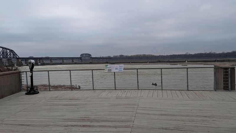
Photographed by Daniel Barriball, December 27, 2025
2. Navigating the Falls of the Ohio Marker in context
Topics. This historical marker is listed in these topic lists: Charity & Public Work • Industry & Commerce • Waterways & Vessels. A significant historical year for this entry is 1881.
Location. 38° 16.584′ N, 85° 45.821′ W. Marker is in Clarksville, Indiana, in Clark County. It can be reached from West Riverside Drive north of West Winbourne Avenue, on the left when traveling north. This marker is on the boardwalk on the river side of the Falls of the Ohio Interpretive Center in Falls of the Ohio State Park. Touch for map. Marker is at or near this postal address: 201 W Riverside Dr, Clarksville IN 47129, United States of America. Touch for directions.

Regionally, this marker is in Southern Indiana. It is also in the American Midwest, in the Ohio River Valley, and in the Corn Belt. Globally, it is in North America, the Western Hemisphere, the Western World, and the Anglosphere. Historically, it finds itself in what was once the territory of the Mississippian Culture and also the Northwest Territory.
Other nearby markers. At least 8 other markers are within walking distance of this marker: John A. Munz and Coast Guard Ohio River History (here, next to this marker); Falls of the Ohio Fossil Beds (within shouting distance of this marker); History’s Great Explorers (within shouting distance of this marker); Indiana State Parks: the First 100 Years 1916-2016 (about 500 feet away, measured in a direct line); Fossils at the Falls (approx. 0.4 miles away); Scenic Spans (approx. 0.6 miles away); Clarksville (approx. 0.7 miles away); Railroad Cars to Go (approx. 0.8 miles away). Touch for a list and map of all markers in Clarksville.
Another marker is no longer nearby. River Navigation (was here, next to this marker but has been confirmed missing).
Also see . . . McAlpine Locks and Dam. Army Corps of Engineers
The Falls of the Ohio are located at Louisville, Kentucky, and are the only falls in the entire length of the Ohio River. They consist of a rock reef extending across the river and forming a rapids having a length of about 3 miles. The low water slope in this distance is 26 feet and the falls or rapids in their natural state were impassable by vessels except at high stages. As early as the year 1802, the expense and delay attending the reshipment of freight around the falls had become so serious that numerous plans were proposed for overcoming the obstruction. No active measures were taken until 1825, when the Louisville and Portland Canal Company obtained a charter from the Commonwealth of Kentucky. This charter authorized the company to construct a canal around the Falls of the Ohio within the State of Kentucky.(Submitted on January 1, 2026, by Daniel Barriball of Chesterton, Indiana.)
Credits. This page was last revised on January 20, 2026. It was originally submitted on December 31, 2025, by Daniel Barriball of Chesterton, Indiana. This page has been viewed 96 times since then and 95 times this year. Last updated on January 17, 2026, by Daniel Barriball of Chesterton, Indiana. Photos: 1. submitted on December 31, 2025, by Daniel Barriball of Chesterton, Indiana. 2. submitted on January 1, 2026, by Daniel Barriball of Chesterton, Indiana. • Devry Becker Jones was the editor who published this page.
